METAR & TAF 6H8
6H8 does not publish a METAR.
Showing the nearest reporting station: KBIS (BISMARCK MUNI) · 26.4 NM away. Conditions at 6H8 may differ.
METAR · KBIS
Observed 14:52Z
KBIS 271452Z 31004KT 10SM CLR 25/16 A2991 RMK AO2 SLP115 T02500156 50000
- Wind
- 310° @ 4 kt
- Visibility
- 10 SM
- Temp / Dew
- 25°C / 16°C
- Altimeter
- 29.91 inHg
- Clouds
- CLR
- Density alt
- 3,711 ft
- Ceiling
- Unlimited
- Rules
- VFR
Airport info & contacts
Manager on record, flight service, ARTCC, attendance schedule and pattern altitude — published by the FAA and refreshed every 28 days.
Location
- From city
- 1 NM E
- VFR sectional
- TWIN CITIES
- ARTCC
- ZMP · MINNEAPOLIS
- NOTAM facility
- GFK (NOTAM-D)
Airport manager
- Name
- MIKE APPERT
- Phone
- 701-321-1587
- Address
- 755 HWY 34, HAZELTON ND 58544
Flight service · Hours
- FSS GFK
- GRAND FORKS1-800-WX-BRIEF
- Attendance
- Unattended
Frequencies
Tap any row to copy the frequency to your clipboard.
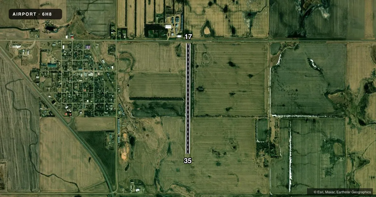
Runways & pattern
Full pagePattern entry · RWY 35
LEFT TRAFFICRunway end performance
| End | TORA | TODA | ASDA | LDA | VGSI | Approach lights | Obstruction |
|---|---|---|---|---|---|---|---|
| 17 | — | — | — | — | — | — | 16', road, 75' from thr, 140' R of cntrln, slope 4 |
| 35 | — | — | — | — | — | — | 25', pline, 450' from thr, 170' R of cntrln, slope 18 |
Declared distances in feet. TORA = takeoff run available, TODA = takeoff distance, ASDA = accelerate-stop, LDA = landing distance.
Airport sketch
Runways drawn to scale from FAA survey coordinates, rendered over satellite imagery. Not for navigation.
Approaches & charts
Services on the field
Fuel grades, oxygen, maintenance, ramp storage and lighting — as declared to the FAA by the airport operator.
Fuel & services
- Fuel
- Not available
- Oxygen (bottled)
- Not available
- Oxygen (bulk)
- Not available
- Airframe repair
- Not available
- Power plant repair
- Not available
- Other services
- AGRI
Ramp & ground
- Transient storage
- Tie-down
- Landing fee
- No fee published
- Customs
- Not available
- Wind indicator
- No
- Segmented circle
- No
Fuel & FBOs
Cheapest 100LL and Jet A on the field and nearby. Always confirm with the FBO before taxi.
Airport notes
Surface conditions, obstructions, local procedures, lighting outages and other notes published with each FAA cycle.
General notes
- PILOTS AT WEST END OF TWY CANNOT SEE ACFT ON OPPOSITE END DUE TO STEEP DOWNSLOPE.
- CFM WINTER COND BFR USE; SN REMOVAL IRREG; CALL (701) 782-6878.
- GRAVEL-DIRT ACES ROAD POOR & SOFT WHEN WET; POTHOLES POSS.
- FOR CD CTC MINNEAPOLIS ARTCC AT 651-463-5588.
Approach & departure obstructions
- 17-3 FT DITCH 30 FT OUBD FM THLD.
- 17ALSO 40 FT TREES 300 FT FM THLD; 150 FT R OF CNTRLN; APCH RATIO 7:1. POSS TURB.
Other notes
- MANAGERADNL CTC JIM MCLEISH 701-782-6816.
- OWNERCITY AUDITOR.
- 17/35SFC FAIR WITH GRASS CLUMPS & HOLES POSS.
VFR map & nearby airports
VFR sectional. Tap any ICAO chip to open that airport.
Key facts · 6H8
Answer card- ICAO
- 6H8
- Name
- HAZELTON MUNI
- Location
- HAZELTON, NORTH DAKOTA
- Elevation
- 2,015 ft MSL
- Traffic pattern altitude
- 3,015 ft MSL (1,000 AGL)
- Control tower
- Non-towered (use CTAF)
- Total runways
- 1
- Longest runway
- 17/35 · 3,800 ft
- Published ILS approaches
- 0
- Published frequencies
- 1
- Magnetic variation
- 9°
- Current flight rules
- VFR
- Current wind
- 310° at 4 kt
- Favored runway now
- RWY 35
Hazelton Muni (6H8) sits in Hazelton, North Dakota. The field elevation is 2,015 ft MSL. It has one runway, 17/35, which is 3,800 ft long and turf. The airport is non-towered. CTAF is 122.9. No ILS approaches are published here.
The pattern altitude is not published, so use the standard 1,000 ft AGL unless the current Chart Supplement says otherwise. That puts the traffic pattern at about 3,015 ft MSL. There are no on-field FBOs listed. Plan fuel and services accordingly. If you need current field support, contact the airport operator or the FBO directly by phone before you go.
The published remarks matter here. Snow removal is irregular, so winter use needs a phone call first. The runway surface is listed as fair, with grass clumps and holes possible. There is also a 3-foot ditch 30 feet beyond the 17 threshold. Trees sit 300 feet from that threshold, 150 feet right of centerline, with possible turbulence. The west end of the taxiway has a visibility issue because pilots there cannot see aircraft on the opposite end due to the steep downslope. This is a small rural strip with a turf surface, so check the current Chart Supplement and local conditions before you launch.