METAR & TAF 5B5
5B5 does not publish a METAR.
Showing the nearest reporting station: KBIS (BISMARCK MUNI) · 44.0 NM away. Conditions at 5B5 may differ.
METAR · KBIS
Observed 15:52Z
KBIS 271552Z 01007KT 10SM CLR 27/16 A2990 RMK AO2 SLP113 T02720161
- Wind
- 010° @ 7 kt
- Visibility
- 10 SM
- Temp / Dew
- 27°C / 16°C
- Altimeter
- 29.90 inHg
- Clouds
- CLR
- Density alt
- 3,926 ft
- Ceiling
- Unlimited
- Rules
- VFR
Airport info & contacts
Manager on record, flight service, ARTCC, attendance schedule and pattern altitude — published by the FAA and refreshed every 28 days.
Location
- From city
- 1 NM SE
- VFR sectional
- TWIN CITIES
- ARTCC
- ZMP · MINNEAPOLIS
- NOTAM facility
- GFK (NOTAM-D)
Airport manager
- Name
- SHANE WEIGEL
- Phone
- 701-426-4537
- Address
- PO BOX 165, NAPOLEON ND 58561
Flight service · Hours
- FSS GFK
- GRAND FORKS1-800-WX-BRIEF
- Attendance
- Unattended
Frequencies
Tap any row to copy the frequency to your clipboard.
Runways & pattern
Full pagePattern entry · RWY 30
LEFT TRAFFIC| Runway | Heading (°M) | Length | Surface | Traffic |
|---|---|---|---|---|
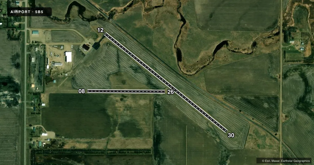
| 12/30Favored | 119° / 299° | 3,220 ft | ASPH | Standard L |
| 08/26 | 81° / 261° | 1,600 ft | TURF | Standard L |
Runway end performance
| End | TORA | TODA | ASDA | LDA | VGSI | Approach lights | Obstruction |
|---|---|---|---|---|---|---|---|
| 12 | — | — | — | — | — | — | 164', bldg, 3160' from thr, 410' R of cntrln, slope 18 |
Declared distances in feet. TORA = takeoff run available, TODA = takeoff distance, ASDA = accelerate-stop, LDA = landing distance.
Airport sketch
Runways drawn to scale from FAA survey coordinates, rendered over satellite imagery. Not for navigation.
Approaches & charts
Services on the field
Fuel grades, oxygen, maintenance, ramp storage and lighting — as declared to the FAA by the airport operator.
Fuel & services
- Fuel
- Not available
- Other services
- AGRI
Ramp & ground
- Transient storage
- Tie-down
- Landing fee
- No fee published
- Lighting schedule
- SEE RMK
- Wind indicator
- Lighted
- Segmented circle
- No
Fuel & FBOs
Cheapest 100LL and Jet A on the field and nearby. Always confirm with the FBO before taxi.
Airport notes
Surface conditions, obstructions, local procedures, lighting outages and other notes published with each FAA cycle.
General notes
- REG SNOW REMOVAL. CFM WINTER COND WITH AMGR DURG DAY ON 701-321-0767 OR 701-426-4537.
- RWY 08/26 CLSD OCT-APR DUE TO LACK OF SNOW REMOVAL.
- RWY 08 HAS 3 FT DITCH 250 FT FROM THR OUTBOUND.
- DEER & BIRDS ON & INVOF ARPT.
- FOR CD CTC MINNEAPOLIS ARTCC AT 651-463-5588.
Lighting notes
- DUSK-0600.
Approach & departure obstructions
- 0828 FT BLDG 1100 FT DIST, 100 FT L; 45 FT TREES 1000 DIST, 100 FT R.
- 2625 FT RAILROAD 500 FT DIST, 200 FT R.
VFR map & nearby airports
VFR sectional. Tap any ICAO chip to open that airport.
Key facts · 5B5
Answer card- ICAO
- 5B5
- Name
- NAPOLEON MUNI
- Location
- NAPOLEON, NORTH DAKOTA
- Elevation
- 1,985 ft MSL
- Traffic pattern altitude
- 2,985 ft MSL (1,000 AGL)
- Control tower
- Non-towered (use CTAF)
- Total runways
- 2
- Longest runway
- 12/30 · 3,220 ft
- Published ILS approaches
- 0
- Published frequencies
- 1
- Magnetic variation
- 9°
- Current flight rules
- VFR
- Current wind
- 010° at 7 kt
- Favored runway now
- RWY 30
Napoleon Muni sits in Napoleon, North Dakota. The field elevation is 1,985 ft MSL. It has two runways. The longest is runway 12/30 at 3,220 ft. Runway 08/26 is turf and 1,600 ft long. This is an uncontrolled field with CTAF 122.9. No ILS approaches are published.
Pattern altitude is not published. For light piston planning, use the standard 1,000 ft AGL unless the current Chart Supplement or local guidance says otherwise. The published remarks matter here. Runway 08/26 is closed from October through April because snow removal is not provided on that strip. Regular snow removal is provided for the airport, so winter conditions still need a check with the airport manager before you go. Lighting is available from dusk to 0600.
There are no on-field FBOs listed. Deer and birds are reported on and near the airport. There is also a railroad near runway 26. A building and trees are noted near runway 08, plus a ditch just beyond the runway 08 threshold. For clearance delivery, contact Minneapolis ARTCC. If you are planning a night arrival or a winter stop, verify the current field condition with the airport manager before departure.