METAR & TAF 3W8
3W8 does not publish a METAR.
Showing the nearest reporting station: KMBG (MOBRIDGE MUNI) · 35.5 NM away. Conditions at 3W8 may differ.
METAR · KMBG
Observed 13:28Z
KMBG 271328Z AUTO 31003KT 5SM HZ CLR 23/16 A2988 RMK AO2 T02280156
- Wind
- 310° @ 3 kt
- Visibility
- 5 SM
- Temp / Dew
- 23°C / 16°C
- Altimeter
- 29.88 inHg
- Clouds
- CLR
- Density alt
- 3,409 ft
- Ceiling
- Unlimited
- Rules
- MVFR
Airport info & contacts
Manager on record, flight service, ARTCC, attendance schedule and pattern altitude — published by the FAA and refreshed every 28 days.
Location
- From city
- 2 NM N
- VFR sectional
- TWIN CITIES
- ARTCC
- ZMP · MINNEAPOLIS
- NOTAM facility
- HON (NOTAM-D)
Airport manager
- Name
- ERIC ODENBACH
- Phone
- 605-228-3262
- Address
- PO BOX 655, EUREKA SD 57437
Flight service · Hours
- FSS HON
- HURON1-800-WX-BRIEF
- Attendance
- Unattended
Frequencies
Tap any row to copy the frequency to your clipboard.
Runways & pattern
Full pagePattern entry · RWY 30
LEFT TRAFFIC| Runway | Heading (°M) | Length | Surface | Traffic |
|---|---|---|---|---|
| 12/30Favored | 127° / 307° | 3,100 ft | ASPH | Standard L |
| 07/25 | 75° / 255° | 1,821 ft | TURF | Standard L |
Runway end performance
| End | TORA | TODA | ASDA | LDA | VGSI | Approach lights | Obstruction |
|---|---|---|---|---|---|---|---|
| 12 | — | — | — | — | PAPI 2-box left(3°) | — | — |
| 30 | — | — | — | — | PAPI 2-box left(3°) | — | — |
| 07 | — | — | — | — | — | — | 4', fence, 80' from thr, 0' R of cntrln, slope 20 |
Declared distances in feet. TORA = takeoff run available, TODA = takeoff distance, ASDA = accelerate-stop, LDA = landing distance.
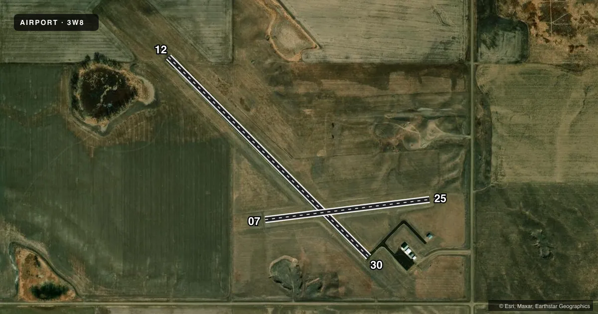
Airport sketch
Runways drawn to scale from FAA survey coordinates, rendered over satellite imagery. Not for navigation.
Approaches & charts
Services on the field
Fuel grades, oxygen, maintenance, ramp storage and lighting — as declared to the FAA by the airport operator.
Fuel & services
- Fuel
- Not available
- Oxygen (bottled)
- Not available
- Oxygen (bulk)
- Not available
- Airframe repair
- Not available
- Power plant repair
- Not available
- Other services
- AGRI
Ramp & ground
- Transient storage
- Tie-down
- Landing fee
- No fee published
- Lighting schedule
- SEE RMK
- Beacon schedule
- SS-SR
- Beacon
- White / Green (civil land)(WG)
- Wind indicator
- Lighted
- Segmented circle
- No
Fuel & FBOs
Cheapest 100LL and Jet A on the field and nearby. Always confirm with the FBO before taxi.
Airport notes
Surface conditions, obstructions, local procedures, lighting outages and other notes published with each FAA cycle.
General notes
- WILDLIFE ON AND INVOF ARPT.
- FOR CD CTC MINNEAPOLIS ARTCC AT 651-463-5588.
Lighting notes
- ACTVT PAPI RWY 12 &30; MIRL RWY 12/30 - CTAF.
Approach & departure obstructions
- 12RWY 12/30 MKGS VERY FADED.
- 07RWY 07/25 MKD WITH WHITE BLACK TIPPED MKR CONES.
VFR map & nearby airports
VFR sectional. Tap any ICAO chip to open that airport.
Key facts · 3W8
Answer card- ICAO
- 3W8
- Name
- EUREKA MUNI
- Location
- EUREKA, SOUTH DAKOTA
- Elevation
- 1,935 ft MSL
- Traffic pattern altitude
- 2,935 ft MSL (1,000 AGL)
- Control tower
- Non-towered (use CTAF)
- Total runways
- 2
- Longest runway
- 12/30 · 3,100 ft
- Published ILS approaches
- 0
- Published frequencies
- 1
- Magnetic variation
- 8°
- Current flight rules
- MVFR
- Current wind
- 310° at 3 kt
- Favored runway now
- RWY 30
Eureka Muni sits in Eureka, South Dakota. The field elevation is 1,935 ft MSL. It has two runways. The longest is runway 12/30 at 3,100 ft asphalt. Runway 07/25 is 1,821 ft turf. There is no control tower. CTAF is 122.9. No ILS approaches are published here.
Pattern altitude is not published. Use the standard 1,000 ft AGL pattern for light piston operations unless the current FAA Chart Supplement says otherwise. That puts the traffic pattern at 2,935 ft MSL based on the listed field elevation. Runway 07 and 25 are marked with white black-tipped marker cones. Runway 12 and 30 have PAPI. They also have medium intensity runway lights that are activated by CTAF. Wildlife is reported on and near the airport, so keep a sharp scan on taxi, takeoff and landing. For clearance delivery, contact Minneapolis ARTCC at 651-463-5588. No on-field FBOs are listed, so verify fuel and services with the airport operator or the FBO directly by phone before you go.