METAR & TAF 8SD
8SD does not publish a METAR.
Showing the nearest reporting station: KMBG (MOBRIDGE MUNI) · 31.4 NM away. Conditions at 8SD may differ.
METAR · KMBG
Observed 00:52Z
KMBG 260052Z AUTO 19004KT 10SM VCTS -RA 24/21 A2982 RMK AO2 PK WND 23042/0026 LTG DSNT E-S RAB08B25 TSB17E52 PRESFR SLP087 P0003 T02440206 $
- Wind
- 190° @ 4 kt
- Visibility
- 10 SM
- Temp / Dew
- 24°C / 21°C
- Altimeter
- 29.82 inHg
- Clouds
- Clear
- Density alt
- 3,638 ft
- Ceiling
- Unlimited
- Rules
- VFR
Airport info & contacts
Manager on record, flight service, ARTCC, attendance schedule and pattern altitude — published by the FAA and refreshed every 28 days.
Location
- From city
- 1 NM SW
- VFR sectional
- TWIN CITIES
- ARTCC
- ZMP · MINNEAPOLIS
- NOTAM facility
- HON (NOTAM-D)
Airport manager
- Name
- RICK BOSCHEE
- Phone
- 605-285-6350
- Address
- C/O TOWN OF BOWDLE, PO BOX 553, BOWDLE SD 57428
Flight service · Hours
- FSS HON
- HURON1-800-WX-BRIEF
- Attendance
- Unattended
Frequencies
Tap any row to copy the frequency to your clipboard.
Runways & pattern
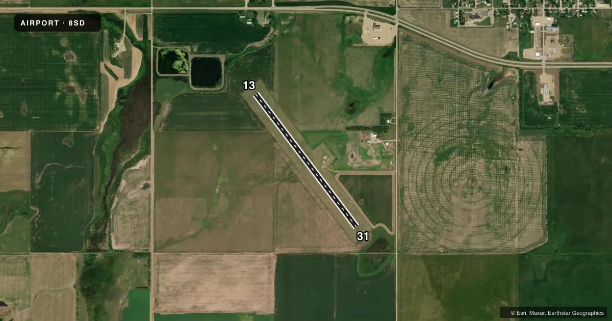
Full pagePattern entry · RWY 13
LEFT TRAFFICAirport sketch
Runways drawn to scale from FAA survey coordinates, rendered over satellite imagery. Not for navigation.
Approaches & charts
Services on the field
Fuel grades, oxygen, maintenance, ramp storage and lighting — as declared to the FAA by the airport operator.
Fuel & services
- Fuel
- Not available
- Oxygen (bottled)
- Not available
- Oxygen (bulk)
- Not available
- Airframe repair
- Not available
- Power plant repair
- Not available
- Other services
- AGRI
Ramp & ground
- Transient storage
- Tie-down
- Landing fee
- No fee published
- Customs
- Not available
- Wind indicator
- Yes
- Segmented circle
- Yes
Fuel & FBOs
Cheapest 100LL and Jet A on the field and nearby. Always confirm with the FBO before taxi.
Airport notes
Surface conditions, obstructions, local procedures, lighting outages and other notes published with each FAA cycle.
General notes
- RY 13 HAS 4 FT FENCE 200 FT FROM THR.
- RY 31 HAS 4 FT FENCE 250 FT FROM THR.
- ARPT CLSD 1 NOV-15 APR.
- WILDLIFE ON AND INVOF ARPT
- ARPT CLSD SS-SR.
- FOR CD CTC MINNEAPOLIS ARTCC AT 651-463-5588.
Approach & departure obstructions
- 13MKD WITH YELLOW AND BLACK METAL A-FRAME MKRS.
- 31MKD WITH YELLOW AND BLACK METAL A-FRAME MKRS.
VFR map & nearby airports
VFR sectional. Tap any ICAO chip to open that airport.
Key facts · 8SD
Answer card- ICAO
- 8SD
- Name
- BOWDLE MUNI
- Location
- BOWDLE, SOUTH DAKOTA
- Elevation
- 1,963 ft MSL
- Traffic pattern altitude
- 2,963 ft MSL (1,000 AGL)
- Control tower
- Non-towered (use CTAF)
- Total runways
- 1
- Longest runway
- 13/31 · 3,600 ft
- Published ILS approaches
- 0
- Published frequencies
- 1
- Magnetic variation
- 8°
- Current flight rules
- VFR
- Current wind
- 190° at 4 kt
- Favored runway now
- RWY 13
Bowdle Muni sits in Bowdle, South Dakota. Field elevation is 1,963 ft MSL. The airport has one runway. Runway 13/31 is 3,600 ft of turf, which is the longest runway on the field. There is no control tower. CTAF is 122.9. No ILS approaches are published here.
The pattern altitude is not published. Use the standard 1,000 ft AGL unless the current Chart Supplement or local briefing says otherwise. The airport is closed from November 1 to April 15. It is also closed from sunset to sunrise. That makes daylight planning important. Runway lighting is out of service indefinitely. The rotating beacon is also out of service indefinitely.
There are no on-field FBOs listed. Contact the airport operator directly or call the field on CTAF for current service status before you go. Published remarks also note a 4 ft fence about 200 ft from the threshold on Runway 13. Runway 31 has a 4 ft fence about 250 ft from the threshold. Wildlife is reported on and near the airport. Runway 13 and Runway 31 are marked with yellow and black metal A-frame markers. For clearance delivery, contact Minneapolis ARTCC at 651-463-5588. This is a turf strip at nearly 2,000 ft MSL. Check surface condition. Check wind. Check density altitude before you commit.