METAR & TAF 9F8
9F8 does not publish a METAR.
Showing the nearest reporting station: KMBG (MOBRIDGE MUNI) · 31.0 NM away. Conditions at 9F8 may differ.
METAR · KMBG
Observed 09:52Z
KMBG 270952Z AUTO 00000KT 5SM BR CLR 18/16 A2983 RMK AO2 SLP087 T01780156 $
- Wind
- 000° @ 0 kt
- Visibility
- 5 SM
- Temp / Dew
- 18°C / 16°C
- Altimeter
- 29.83 inHg
- Clouds
- CLR
- Density alt
- 2,809 ft
- Ceiling
- Unlimited
- Rules
- MVFR
Airport info & contacts
Manager on record, flight service, ARTCC, attendance schedule and pattern altitude — published by the FAA and refreshed every 28 days.
Location
- From city
- 2 NM NW
- VFR sectional
- TWIN CITIES
- ARTCC
- ZMP · MINNEAPOLIS
- NOTAM facility
- HON (NOTAM-D)
Airport manager
- Name
- KEVIN JOHNSON
- Phone
- 605-948-2257
- Address
- PO BOX 157, HOVEN SD 57450
Flight service · Hours
- FSS HON
- HURON1-800-WX-BRIEF
- Attendance
- Unattended
Frequencies
Tap any row to copy the frequency to your clipboard.
Runways & pattern
Full pagePattern entry · RWY 13
LEFT TRAFFICRunway end performance
| End | TORA | TODA | ASDA | LDA | VGSI | Approach lights | Obstruction |
|---|---|---|---|---|---|---|---|
| 13 | — | — | — | — | PAPI 2-box left(3°) | — | — |
| 31 | — | — | — | — | PAPI 2-box left(3°) | — | 18', road, 600' from thr, 0' R of cntrln, slope 22 |
Declared distances in feet. TORA = takeoff run available, TODA = takeoff distance, ASDA = accelerate-stop, LDA = landing distance.
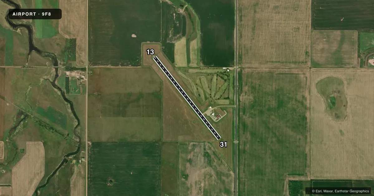
Airport sketch
Runways drawn to scale from FAA survey coordinates, rendered over satellite imagery. Not for navigation.
Approaches & charts
Services on the field
Fuel grades, oxygen, maintenance, ramp storage and lighting — as declared to the FAA by the airport operator.
Fuel & services
- Fuel
- 100LL
- Oxygen (bottled)
- Not available
- Oxygen (bulk)
- Not available
- Airframe repair
- Not available
- Power plant repair
- Not available
- Other services
- AGRI
Ramp & ground
- Transient storage
- Tie-down
- Hangar
- Landing fee
- No fee published
- Customs
- Not available
- Lighting schedule
- SEE RMK
- Beacon schedule
- SS-SR
- Beacon
- White / Green (civil land)(WG)
- Wind indicator
- Lighted
- Segmented circle
- Yes
Fuel & FBOs
Cheapest 100LL and Jet A on the field and nearby. Always confirm with the FBO before taxi.
Airport notes
Surface conditions, obstructions, local procedures, lighting outages and other notes published with each FAA cycle.
General notes
- CHURCH STEEPLE 2029 FT MSL 6800 FT FM RWY 31 THLD.
- FOR CD CTC MINNEAPOLIS ARTCC AT 651-463-5588.
Lighting notes
- ACTVT MIRL RWY 13/31; PAPI RWY 13 & 31 - CTAF.
VFR map & nearby airports
VFR sectional. Tap any ICAO chip to open that airport.
Key facts · 9F8
Answer card- ICAO
- 9F8
- Name
- HOVEN MUNI
- Location
- HOVEN, SOUTH DAKOTA
- Elevation
- 1,885.4 ft MSL
- Traffic pattern altitude
- 2,885.4 ft MSL (1,000 AGL)
- Control tower
- Non-towered (use CTAF)
- Total runways
- 1
- Longest runway
- 13/31 · 3,700 ft
- Published ILS approaches
- 0
- Published frequencies
- 2
- Magnetic variation
- 9°
- Current flight rules
- MVFR
- Current wind
- 000° at 0 kt
- Favored runway now
- –
Hoven Muni is in Hoven, South Dakota. The field elevation is 1,885.4 ft MSL. It has one runway, 13/31, which is 3,700 ft long and asphalt. There is no control tower. CTAF and UNICOM are both 122.8. No ILS approaches are published here.
The pattern altitude is not published, so use the standard 1,000 ft AGL for light piston operations unless the current Chart Supplement says otherwise. With the field sitting near 1,900 ft MSL, expect a higher true altitude than you may be used to at lower-elevation airports. That matters for climb performance and landing distance.
No on-field FBOs are listed. Check with the airport operator before arrival if you need fuel or other services. Published remarks note a church steeple at 2,029 ft MSL about 6,800 ft from the runway 31 threshold. That is worth keeping in mind on the approach to 31. The runway lights on 13/31 are medium intensity. The PAPI on both ends is activated by CTAF. For clearance delivery, Minneapolis ARTCC can be reached at 651-463-5588. If you are planning a night or marginal-weather arrival, verify the current Chart Supplement and be ready for a non-towered field with limited approach options.