METAR & TAF 9D0
9D0 does not publish a METAR.
Showing the nearest reporting station: KPIR (PIERRE RGNL) · 37.0 NM away. Conditions at 9D0 may differ.
METAR · KPIR
Observed 12:53Z
KPIR 271253Z AUTO 05008KT 6SM HZ CLR 24/16 A2985 RMK AO2 SLP088 T02390161
- Wind
- 050° @ 8 kt
- Visibility
- 6 SM
- Temp / Dew
- 24°C / 16°C
- Altimeter
- 29.85 inHg
- Clouds
- CLR
- Density alt
- 3,466 ft
- Ceiling
- Unlimited
- Rules
- VFR
Airport info & contacts
Manager on record, flight service, ARTCC, attendance schedule and pattern altitude — published by the FAA and refreshed every 28 days.
Location
- From city
- 1 NM N
- VFR sectional
- TWIN CITIES
- ARTCC
- ZMP · MINNEAPOLIS
- NOTAM facility
- HON (NOTAM-D)
Airport manager
- Name
- CHAD CRAGO
- Phone
- 605-871-9945
- Address
- PO BOX 299, HIGHMORE SD 57345
Flight service · Hours
- FSS HON
- HURON1-800-WX-BRIEF
- Attendance
- Unattended
Frequencies
Tap any row to copy the frequency to your clipboard.
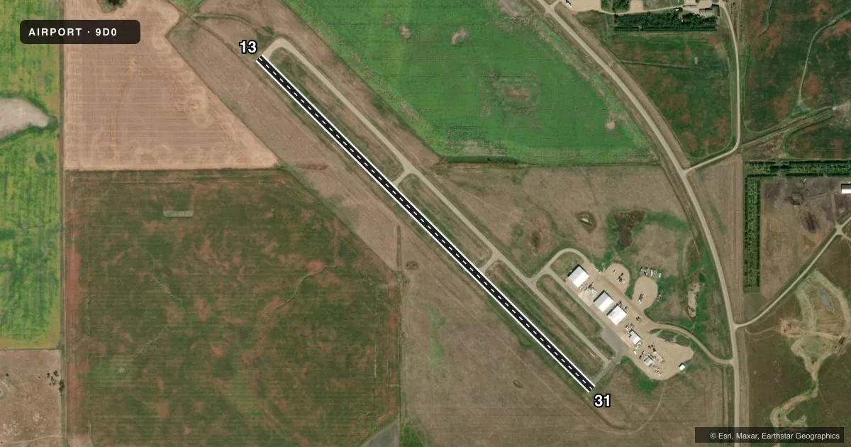
Runways & pattern
Full pagePattern entry · RWY 13
LEFT TRAFFICRunway end performance
| End | TORA | TODA | ASDA | LDA | VGSI | Approach lights | Obstruction |
|---|---|---|---|---|---|---|---|
| 13 | — | — | — | — | — | — | 10', fence, 625' from thr, 0' R of cntrln, slope 42 |
Declared distances in feet. TORA = takeoff run available, TODA = takeoff distance, ASDA = accelerate-stop, LDA = landing distance.
Airport sketch
Runways drawn to scale from FAA survey coordinates, rendered over satellite imagery. Not for navigation.
Approaches & charts
Services on the field
Fuel grades, oxygen, maintenance, ramp storage and lighting — as declared to the FAA by the airport operator.
Fuel & services
- Fuel
- Not available
- Oxygen (bottled)
- Not available
- Oxygen (bulk)
- Not available
- Airframe repair
- Minor
- Power plant repair
- Minor
- Other services
- AGRI,INSTR
Ramp & ground
- Transient storage
- Tie-down
- Landing fee
- No fee published
- Customs
- Not available
- Lighting schedule
- SS-SR
- Beacon schedule
- SS-SR
- Beacon
- White / Green (civil land)(WG)
- Wind indicator
- Lighted
- Segmented circle
- No
Fuel & FBOs
Cheapest 100LL and Jet A on the field and nearby. Always confirm with the FBO before taxi.
Airport notes
Surface conditions, obstructions, local procedures, lighting outages and other notes published with each FAA cycle.
General notes
- FOR CD CTC MINNEAPOLIS ARTCC AT 651-463-5588.
VFR map & nearby airports
VFR sectional. Tap any ICAO chip to open that airport.
Key facts · 9D0
Answer card- ICAO
- 9D0
- Name
- HIGHMORE MUNI
- Location
- HIGHMORE, SOUTH DAKOTA
- Elevation
- 1,854.3 ft MSL
- Traffic pattern altitude
- 2,854.3 ft MSL (1,000 AGL)
- Control tower
- Non-towered (use CTAF)
- Total runways
- 1
- Longest runway
- 13/31 · 3,701 ft
- Published ILS approaches
- 0
- Published frequencies
- 1
- Magnetic variation
- 5°
- Current flight rules
- VFR
- Current wind
- 050° at 8 kt
- Favored runway now
- RWY 13
Highmore Muni is in Highmore, South Dakota. The field elevation is 1,854.3 ft MSL. It has one runway, 13/31, which is 3,701 ft asphalt. There is no control tower. CTAF is 122.9.
No ILS approaches are published here. Pattern altitude is not published, so use the standard 1,000 ft AGL unless the current Chart Supplement says otherwise. With the elevation at 1,854.3 ft MSL, that puts the standard pattern at about 2,854 ft MSL.
There are no on-field FBOs listed in the facts. Plan on confirming services before you go. For clearance delivery, contact Minneapolis ARTCC at 651-463-5588. The runway is short enough that performance planning matters, especially on a warm day or with a heavier load. This is an uncontrolled field, so keep your radio work tight and watch for local traffic on CTAF 122.9.