METAR & TAF 1D8
Current METAR
Observed 10:55Z
K1D8 261055Z AUTO 14008KT 10SM CLR 22/21 A2977 RMK AO2
- Wind
- 140° @ 8 kt
- Visibility
- 10 SM
- Temp / Dew
- 22°C / 21°C
- Altimeter
- 29.77 inHg
- Clouds
- CLR
- Density alt
- 2,649 ft
- Ceiling
- Unlimited
- Rules
- VFR
Airport info & contacts
Manager on record, flight service, ARTCC, attendance schedule and pattern altitude — published by the FAA and refreshed every 28 days.
Location
- From city
- 1 NM SW
- VFR sectional
- TWIN CITIES
- ARTCC
- ZMP · MINNEAPOLIS
- NOTAM facility
- HON (NOTAM-D)
Airport manager
- Name
- ADAM HANSEN
- Phone
- 605-472-4550
- Address
- 626 N MAIN ST, REDFIELD SD 57469-1127
Flight service · Hours
- FSS HON
- HURON1-800-WX-BRIEF
- Attendance
- Unattended
Frequencies
Tap any row to copy the frequency to your clipboard.
Runways & pattern
Full pagePattern entry · RWY 17
LEFT TRAFFICRunway end performance
| End | TORA | TODA | ASDA | LDA | VGSI | Approach lights | Obstruction |
|---|---|---|---|---|---|---|---|
| 17 | — | — | — | — | PAPI 2-box right(3°) | — | — |
| 35 | — | — | — | — | PAPI 2-box left(3°) | — | — |
Declared distances in feet. TORA = takeoff run available, TODA = takeoff distance, ASDA = accelerate-stop, LDA = landing distance.
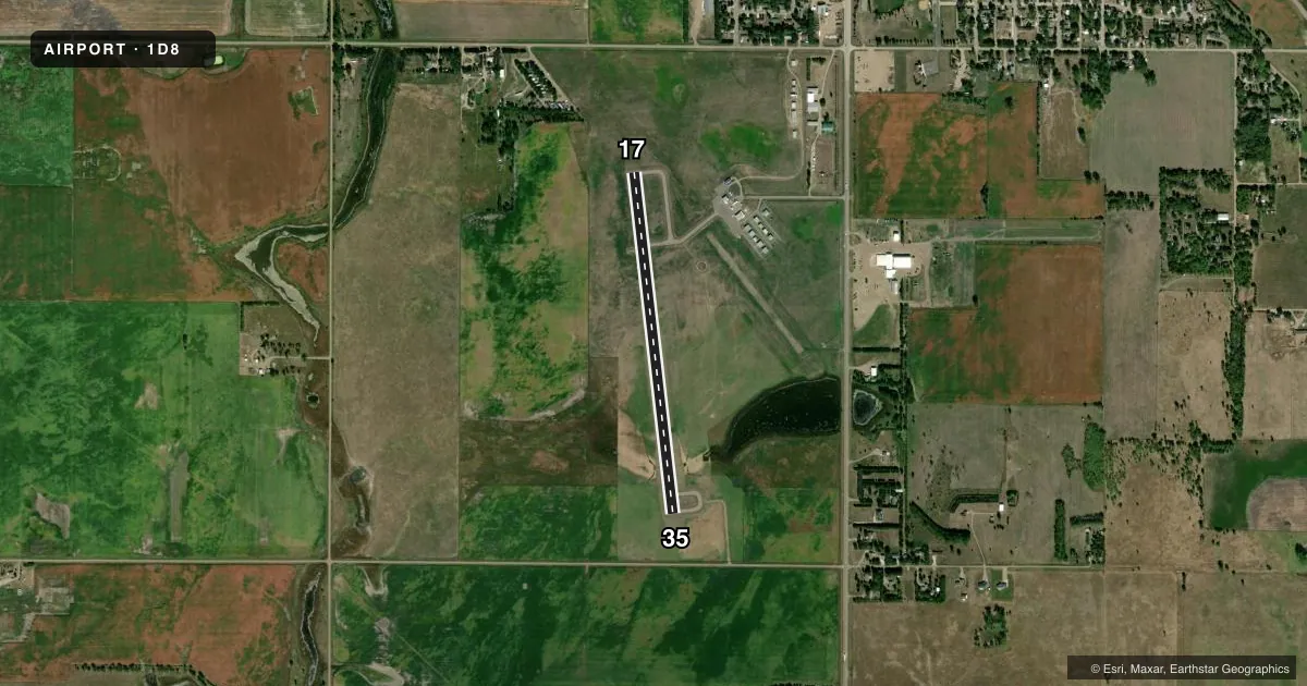
Airport sketch
Runways drawn to scale from FAA survey coordinates, rendered over satellite imagery. Not for navigation.
Approaches & charts
Services on the field
Fuel grades, oxygen, maintenance, ramp storage and lighting — as declared to the FAA by the airport operator.
Fuel & services
- Fuel
- 100LL
- Oxygen (bottled)
- Not available
- Oxygen (bulk)
- Not available
- Airframe repair
- Minor
- Power plant repair
- Minor
- Other services
- AGRI,AMB
Ramp & ground
- Transient storage
- Tie-down
- Landing fee
- No fee published
- Customs
- Not available
- Lighting schedule
- SEE RMK
- Beacon schedule
- SS-SR
- Beacon
- White / Green (civil land)(WG)
- Wind indicator
- Lighted
- Segmented circle
- Yes
Fuel & FBOs
Cheapest 100LL and Jet A on the field and nearby. Always confirm with the FBO before taxi.
Airport notes
Surface conditions, obstructions, local procedures, lighting outages and other notes published with each FAA cycle.
General notes
- ULTRALIGHT ACTIVITY ON AND INVOF ARPT.
- MIGRATORY BIRDS AND WILDILFE ON AND INVOF ARPT.
- FOR CD CTC MINNEAPOLIS ARTCC AT 651-463-5588.
Lighting notes
- ACTVT PAPI RWY 17 & 35; MIRL 17/35 - CTAF.
Fuel notes
- 100LLFUEL AVBL 24 HRS WITH CREDIT CARD.
Other notes
- UNICOM UNMONITORED.
VFR map & nearby airports
VFR sectional. Tap any ICAO chip to open that airport.
Key facts · 1D8
Answer card- ICAO
- 1D8
- Name
- REDFIELD MUNI
- Location
- REDFIELD, SOUTH DAKOTA
- Elevation
- 1,308.5 ft MSL
- Traffic pattern altitude
- 2,308.5 ft MSL (1,000 AGL)
- Control tower
- Non-towered (use CTAF)
- Total runways
- 1
- Longest runway
- 17/35 · 3,500 ft
- Published ILS approaches
- 0
- Published frequencies
- 2
- Magnetic variation
- 7°
- Current flight rules
- VFR
- Current wind
- 140° at 8 kt
- Favored runway now
- RWY 17
Redfield Muni is in Redfield, South Dakota. The field elevation is 1,308.5 ft MSL. It has one runway, 17/35, which is 3,500 ft long and surfaced asphalt-concrete. There is no control tower. CTAF and UNICOM are both 122.8, but UNICOM is unmonitored. No ILS approaches are published here.
The published pattern altitude is not listed. Use the standard 1,000 ft AGL for light piston traffic unless local procedures say otherwise. That puts the traffic pattern at about 2,308.5 ft MSL based on the field elevation. Check the current Chart Supplement before you go if you need any local pattern detail.
The on-field FBO is Redfield Municipal Airport. It carries 100LL. Fuel is available 24 hours with credit card. PAPI is available for both runway directions. Medium intensity runway lights for 17/35 are controlled on CTAF. Wildlife is a factor here. Migratory birds are present on and near the airport. Ultralight activity is also reported on and near the field. For IFR clearance delivery, contact Minneapolis ARTCC at 651-463-5588.