METAR & TAF 4X4
4X4 does not publish a METAR.
Showing the nearest reporting station: KHON (HURON RGNL) · 23.4 NM away. Conditions at 4X4 may differ.
METAR · KHON
Observed 16:55Z
KHON 271655Z AUTO 35007KT 10SM CLR 30/16 A2986 RMK AO2 SLP100 T03000161
- Wind
- 350° @ 7 kt
- Visibility
- 10 SM
- Temp / Dew
- 30°C / 16°C
- Altimeter
- 29.86 inHg
- Clouds
- CLR
- Density alt
- 3,790 ft
- Ceiling
- Unlimited
- Rules
- VFR
Airport info & contacts
Manager on record, flight service, ARTCC, attendance schedule and pattern altitude — published by the FAA and refreshed every 28 days.
Location
- From city
- 2 NM E
- VFR sectional
- OMAHA
- ARTCC
- ZMP · MINNEAPOLIS
- NOTAM facility
- HON (NOTAM-D)
Airport manager
- Name
- BRIAN BERGELEEN
- Phone
- 605-539-1691
- Address
- PO BOX 100, WESSINGTON SPRINGS SD 57382
Flight service · Hours
- FSS HON
- HURON1-800-WX-BRIEF
- Attendance
- Unattended
Frequencies
Tap any row to copy the frequency to your clipboard.
Runways & pattern
Full pagePattern entry · RWY 30
LEFT TRAFFICRunway end performance
| End | TORA | TODA | ASDA | LDA | VGSI | Approach lights | Obstruction |
|---|---|---|---|---|---|---|---|
| 12 | — | — | — | — | PAPI 4-box left(3°) | — | 25', pline, 832' from thr, 390' R of cntrln, slope 25 |
| 30 | — | — | — | — | PAPI 4-box left(3°) | — | — |
Declared distances in feet. TORA = takeoff run available, TODA = takeoff distance, ASDA = accelerate-stop, LDA = landing distance.
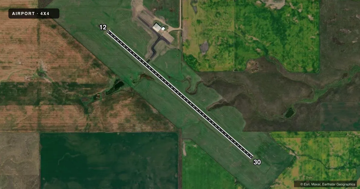
Airport sketch
Runways drawn to scale from FAA survey coordinates, rendered over satellite imagery. Not for navigation.
Approaches & charts
Services on the field
Fuel grades, oxygen, maintenance, ramp storage and lighting — as declared to the FAA by the airport operator.
Fuel & services
- Fuel
- 100LL
- Other services
- AGRI
Ramp & ground
- Transient storage
- Tie-down
- Hangar
- Lighting schedule
- SEE RMK
- Beacon schedule
- SEE RMK
- Beacon
- White / Green (civil land)(WG)
- Wind indicator
- Yes
- Segmented circle
- No
Fuel & FBOs
Cheapest 100LL and Jet A on the field and nearby. Always confirm with the FBO before taxi.
Airport notes
Surface conditions, obstructions, local procedures, lighting outages and other notes published with each FAA cycle.
General notes
- FOR CD CTC MINNEAPOLIS ARTCC AT 651-463-5588.
Lighting notes
- ROTG BCN - CTAF.
- ACTVT MIRL RY 12/30; REIL & PAPI RYS 12 & 30 - CTAF.
Other notes
- SEE ALP LTR DATED JUNE 6, 1996.
- MANAGERCOUNTY OFFICES # 605-539-1691.
VFR map & nearby airports
VFR sectional. Tap any ICAO chip to open that airport.
Key facts · 4X4
Answer card- ICAO
- 4X4
- Name
- WESSINGTON SPRINGS
- Location
- WESSINGTON SPRINGS, SOUTH DAKOTA
- Elevation
- 1,544.5 ft MSL
- Traffic pattern altitude
- 2,544.5 ft MSL (1,000 AGL)
- Control tower
- Non-towered (use CTAF)
- Total runways
- 1
- Longest runway
- 12/30 · 3,600 ft
- Published ILS approaches
- 0
- Published frequencies
- 1
- Magnetic variation
- 4°
- Current flight rules
- VFR
- Current wind
- 350° at 7 kt
- Favored runway now
- RWY 30
Wessington Springs Airport (4X4) sits in Wessington Springs, South Dakota. The field elevation is 1,544.5 ft MSL. It has one runway. Runway 12/30 is 3,600 ft long and asphalt. The airport is not towered. CTAF is 122.9.
No ILS approaches are published here. The pattern altitude is not published, so use standard 1,000 ft AGL unless the current Chart Supplement says otherwise. The published runway lighting matters here. Medium intensity runway lights are available on 12/30. Runway end identifier lights and PAPI are on both ends. They are controlled by CTAF. The rotating beacon is also controlled by CTAF.
Wessington Springs Airport has one on-field FBO. Wessington Springs Airport carries AVGAS 100LL. Call (605) 539-1691 before arrival if you need current service details. For clearance delivery, contact Minneapolis ARTCC at 651-463-5588. This is a small non-towered field, so plan your arrival with the CTAF traffic picture in mind. Check the current Chart Supplement for any updated remarks before you go.