METAR & TAF 1D3
1D3 does not publish a METAR.
Showing the nearest reporting station: KAGZ (WAGNER MUNI) · 31.0 NM away. Conditions at 1D3 may differ.
METAR · KAGZ
Observed 17:15Z
KAGZ 271715Z AUTO 06009KT 10SM CLR 33/21 A2987 RMK AO2
- Wind
- 060° @ 9 kt
- Visibility
- 10 SM
- Temp / Dew
- 33°C / 21°C
- Altimeter
- 29.87 inHg
- Clouds
- CLR
- Density alt
- 4,228 ft
- Ceiling
- Unlimited
- Rules
- VFR
Airport info & contacts
Manager on record, flight service, ARTCC, attendance schedule and pattern altitude — published by the FAA and refreshed every 28 days.
Location
- From city
- 1 NM NE
- VFR sectional
- OMAHA
- ARTCC
- ZMP · MINNEAPOLIS
- NOTAM facility
- HON (NOTAM-D)
Airport manager
- Name
- CITY OF PLATTE
- Phone
- 605-337-3921
- Address
- PO BOX 754, PLATTE SD 57369
Flight service · Hours
- FSS HON
- HURON1-800-WX-BRIEF
- Attendance
- MON-SAT · 0800-1700
Frequencies
Tap any row to copy the frequency to your clipboard.
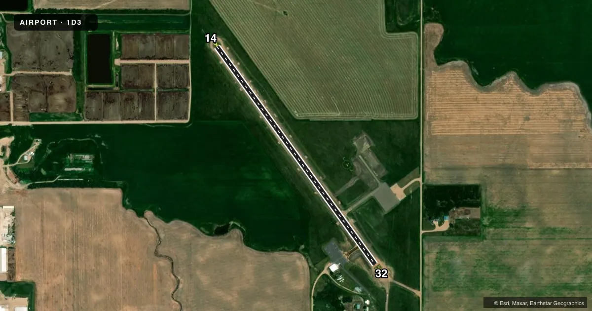
Runways & pattern
Full pagePattern entry · RWY 14
LEFT TRAFFICRunway end performance
| End | TORA | TODA | ASDA | LDA | VGSI | Approach lights | Obstruction |
|---|---|---|---|---|---|---|---|
| 14 | — | — | — | — | PAPI 2-box left | — | 18', tree, 578' from thr, 20' R of cntrln, slope 21 |
| 32 | — | — | — | — | PAPI 2-box left | — | 50', trees, 1250' from thr, 10' R of cntrln, slope 21 |
Declared distances in feet. TORA = takeoff run available, TODA = takeoff distance, ASDA = accelerate-stop, LDA = landing distance.
Airport sketch
Runways drawn to scale from FAA survey coordinates, rendered over satellite imagery. Not for navigation.
Approaches & charts
Services on the field
Fuel grades, oxygen, maintenance, ramp storage and lighting — as declared to the FAA by the airport operator.
Fuel & services
- Fuel
- 100LL
- Oxygen (bottled)
- Not available
- Oxygen (bulk)
- Not available
- Airframe repair
- Not available
- Power plant repair
- Not available
- Other services
- AGRI
Ramp & ground
- Transient storage
- Tie-down
- Landing fee
- No fee published
- Customs
- Not available
- Lighting schedule
- SEE RMK
- Beacon schedule
- SS-SR
- Beacon
- White / Green (civil land)(WG)
- Wind indicator
- Lighted
- Segmented circle
- Yes
Fuel & FBOs
Cheapest 100LL and Jet A on the field and nearby. Always confirm with the FBO before taxi.
Airport notes
Surface conditions, obstructions, local procedures, lighting outages and other notes published with each FAA cycle.
General notes
- DURING WINTER MONTHS RY COULD BE SLIPPERY; CFM WINTER CONDS WITH AMGR CALL (605) 337-2334/3923.
- DEER & OTHER WILDLIFE ON & INVOF ARPT.
- GCO AVBL ON FREQ 121.725 ( 4 CLICKS TO MINNEAPOLIS CENTER AND 6 CLIKCS TO FLIGHT SERVICES)
- FOR CD IF UNA VIA GCO CTC MINNEAPOLIS ARTCC AT 651-463-5588.
Lighting notes
- ACTVT MIRL RY 14/32 - CTAF.
Fuel notes
- 100LLFUEL AVBL 24 HRS WITH CREDIT CARD.
Other notes
- AUTOMATED UNICOM.
VFR map & nearby airports
VFR sectional. Tap any ICAO chip to open that airport.
Key facts · 1D3
Answer card- ICAO
- 1D3
- Name
- PLATTE MUNI
- Location
- PLATTE, SOUTH DAKOTA
- Elevation
- 1,618 ft MSL
- Traffic pattern altitude
- 2,618 ft MSL (1,000 AGL)
- Control tower
- Non-towered (use CTAF)
- Total runways
- 1
- Longest runway
- 14/32 · 3,100 ft
- Published ILS approaches
- 0
- Published frequencies
- 2
- Magnetic variation
- 8°
- Current flight rules
- VFR
- Current wind
- 060° at 9 kt
- Favored runway now
- RWY 14
Platte Muni is in Platte, South Dakota. The field elevation is 1,618 ft MSL. It has one runway. Runway 14/32 is 3,100 ft long with a concrete surface. There is no control tower. CTAF and UNICOM are both 122.8. No ILS approaches are published here.
Pattern altitude is not published. Use 1,000 ft AGL as the standard light-piston pattern unless local procedures or the current FAA Chart Supplement say otherwise. The airport sits in open country, so expect wildlife on and near the movement area. Winter operations can also bring a slippery runway. Check conditions before you go if the surface has been cold-soaked or recently snow covered.
The on-field FBO is Platte Municipal Airport. It carries 100LL. Fuel is available 24 hours with credit card. Medium intensity runway lights on 14/32 are activated from CTAF. There is also an automated UNICOM and a GCO on 121.725 for center and flight service access. For a first-time arrival, the main things to plan around are the non-towered pattern, the single 3,100 ft runway. You will also want current winter and wildlife awareness before landing.