METAR & TAF KAGZ
Current METAR
Observed 16:15Z
KAGZ 271615Z AUTO 05010KT 10SM CLR 33/29 A2985 RMK AO2
- Wind
- 050° @ 10 kt
- Visibility
- 10 SM
- Temp / Dew
- 33°C / 29°C
- Altimeter
- 29.85 inHg
- Clouds
- CLR
- Density alt
- 4,079 ft
- Ceiling
- Unlimited
- Rules
- VFR
Airport info & contacts
Manager on record, flight service, ARTCC, attendance schedule and pattern altitude — published by the FAA and refreshed every 28 days.
Location
- From city
- 1 NM S
- VFR sectional
- OMAHA
- ARTCC
- ZMP · MINNEAPOLIS
- NOTAM facility
- HON (NOTAM-D)
Airport manager
- Name
- JOHN OTTE
- Phone
- 605-384-5858
- Address
- PO BOX 576, WAGNER SD 57380
Flight service · Hours
- FSS HON
- HURON1-800-WX-BRIEF
- Attendance
- MON-FRI · 0700-1700
Frequencies
Tap any row to copy the frequency to your clipboard.
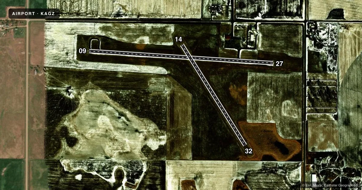
Runways & pattern
Full pagePattern entry · RWY 09
LEFT TRAFFIC| Runway | Heading (°M) | Length | Surface | Traffic |
|---|---|---|---|---|
| 09/27Favored | 90° / 270° | 3,500 ft | ASPH | Standard L |
| 14/32 | 144° / 324° | 2,252 ft | TURF | Standard L |
Runway end performance
| End | TORA | TODA | ASDA | LDA | VGSI | Approach lights | Obstruction |
|---|---|---|---|---|---|---|---|
| 09 | — | — | — | — | PAPI 2-box left(3°) | — | 28', pline, 1205' from thr, 90' R of cntrln, slope 35 |
| 27 | — | — | — | — | PAPI 2-box left(3°) | — | 15', road, 620' from thr, 0' R of cntrln, slope 28 |
| 14 | — | — | — | — | — | — | 19', road, 470' from thr, 0' R of cntrln, slope 24 |
| 32 | — | — | — | — | — | — | 141', pline, 3392' from thr, 0' R of cntrln, slope 24 |
Declared distances in feet. TORA = takeoff run available, TODA = takeoff distance, ASDA = accelerate-stop, LDA = landing distance.
Airport sketch
Runways drawn to scale from FAA survey coordinates, rendered over satellite imagery. Not for navigation.
Approaches & charts
Services on the field
Fuel grades, oxygen, maintenance, ramp storage and lighting — as declared to the FAA by the airport operator.
Fuel & services
- Fuel
- 100LL
- Oxygen (bottled)
- Not available
- Oxygen (bulk)
- Not available
- Airframe repair
- Major
- Power plant repair
- Major
- Other services
- AGRI
Ramp & ground
- Transient storage
- Tie-down
- Hangar
- Landing fee
- No fee published
- Customs
- Not available
- Lighting schedule
- SEE RMK
- Beacon schedule
- SS-SR
- Beacon
- White / Green (civil land)(WG)
- Wind indicator
- Lighted
- Segmented circle
- Yes
Fuel & FBOs
Cheapest 100LL and Jet A on the field and nearby. Always confirm with the FBO before taxi.
Airport notes
Surface conditions, obstructions, local procedures, lighting outages and other notes published with each FAA cycle.
General notes
- SPRAY ACFT OPERATING INVOF ARPT APR-NOV.
- RY 14/32 CLSD 1 NOV-15 APR.
- FOR CD CTC MINNEAPOLIS ARTCC AT 651-463-5588.
Lighting notes
- ACTVT PAPI RWY 9 & RWY 27; MIRL RWY 09/27 OPERATE DUSK-0000. AFT 0000 ACTVT - CTAF.
Approach & departure obstructions
- 14MKD WITH BLACK AND W CONES.
- 32MKD WITH BLACK AND W CONES.
Other notes
- PRVDD AN UNOBSTRUCTED 20:1 APCH SLOPE AT EACH END OF RWY IS MAINTAINED.
- AUTOMATED UNICOM.
- 1FOR ATTENDANT AFT HRS CALL 605-487-6262/491-0470.
VFR map & nearby airports
VFR sectional. Tap any ICAO chip to open that airport.
Key facts · KAGZ
Answer card- ICAO
- KAGZ
- Name
- WAGNER MUNI
- Location
- WAGNER, SOUTH DAKOTA
- Elevation
- 1,477.5 ft MSL
- Traffic pattern altitude
- 2,477.5 ft MSL (1,000 AGL)
- Control tower
- Non-towered (use CTAF)
- Total runways
- 2
- Longest runway
- 09/27 · 3,500 ft
- Published ILS approaches
- 0
- Published frequencies
- 2
- Magnetic variation
- 4°
- Current flight rules
- VFR
- Current wind
- 050° at 10 kt
- Favored runway now
- RWY 09
Wagner Muni sits in Wagner, South Dakota. Field elevation is 1,477.5 ft MSL. The airport has two runways. The longest is Runway 09/27 at 3,500 ft of asphalt. Runway 14/32 is 2,252 ft of turf. It is closed from November 1 through April 15. There is no control tower. CTAF and UNICOM are both 122.8. No ILS approaches are published.
Pattern altitude is not published. Use the standard 1,000 ft AGL pattern for light piston operations unless the current FAA Chart Supplement says otherwise. The on-field FBO is Dakota Aircare. It carries 100LL. Call them at (605) 384-5858 for current service details. Published remarks also note that PAPI is active on Runways 09 and 27. Medium intensity runway lights on 09 and 27 run from dusk to 0000. After 0000, lighting activation is by CTAF. Runway 14 and Runway 32 are marked with black and white cones.
For a first-time arrival, the main things to plan for are the non-towered pattern, the seasonal closure of the turf runway and local spray aircraft activity from April through November. Clearance delivery is handled through Minneapolis ARTCC at 651-463-5588. Check the current FAA Chart Supplement for any updates before you go.