METAR & TAF KONL
Current METAR
Observed 17:15Z
KONL 271715Z AUTO 06013KT 10SM CLR 35/24 A2989 RMK AO2 T03460236
- Wind
- 060° @ 13 kt
- Visibility
- 10 SM
- Temp / Dew
- 35°C / 24°C
- Altimeter
- 29.89 inHg
- Clouds
- CLR
- Density alt
- 4,959 ft
- Ceiling
- Unlimited
- Rules
- VFR
Airport info & contacts
Manager on record, flight service, ARTCC, attendance schedule and pattern altitude — published by the FAA and refreshed every 28 days.
Location
- From city
- 2 NM NW
- VFR sectional
- OMAHA
- ARTCC
- ZMP · MINNEAPOLIS
- NOTAM facility
- ONL (NOTAM-D)
Airport manager
- Name
- CORY JOHNSON
- Phone
- 402-760-1232
- Address
- 87204 JOHN L BAKER ROAD, O'NEILL NE 68763-4614
Flight service · Hours
- FSS OLU
- COLUMBUS1-800-WX-BRIEF
- Attendance
- ALL
Frequencies
Tap any row to copy the frequency to your clipboard.
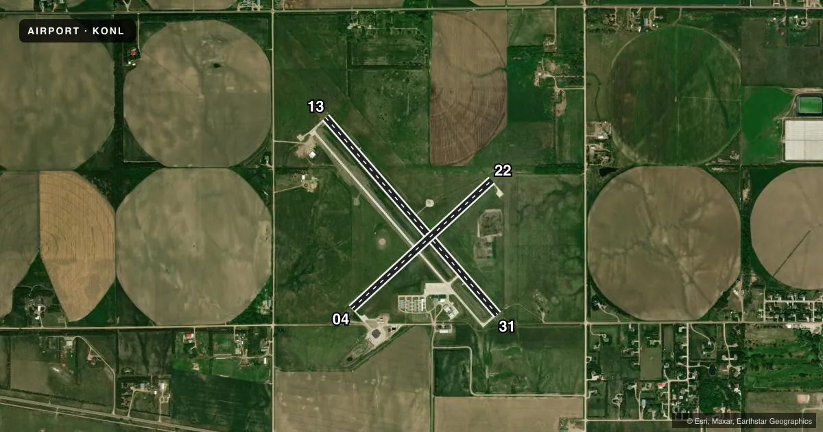
Runways & pattern
Full pagePattern entry · RWY 04
LEFT TRAFFIC| Runway | Heading (°M) | Length | Surface | Traffic |
|---|---|---|---|---|
| 13/31 | 130° / 310° | 4,408 ft | CONC | Standard L |
| 04/22Favored | 39° / 219° | 3,200 ft | CONC | Standard L |
Runway end performance
| End | TORA | TODA | ASDA | LDA | VGSI | Approach lights | Obstruction |
|---|---|---|---|---|---|---|---|
| 13 | — | — | — | — | PAPI 2-box left(3°) | — | — |
| 31 | — | — | — | — | PAPI 2-box left(3°) | — | — |
Declared distances in feet. TORA = takeoff run available, TODA = takeoff distance, ASDA = accelerate-stop, LDA = landing distance.
Airport sketch
Runways drawn to scale from FAA survey coordinates, rendered over satellite imagery. Not for navigation.
Approaches & charts
Services on the field
Fuel grades, oxygen, maintenance, ramp storage and lighting — as declared to the FAA by the airport operator.
Fuel & services
- Fuel
- 100LLA+
- Oxygen (bottled)
- Not available
- Oxygen (bulk)
- Not available
- Airframe repair
- Major
- Power plant repair
- Major
- Other services
- AGRI,INSTR,RNTL
Ramp & ground
- Transient storage
- Tie-down
- Hangar
- Landing fee
- No fee published
- Customs
- Not available
- Lighting schedule
- SEE RMK
- Beacon schedule
- SS-SR
- Beacon
- White / Green (civil land)(WG)
- Wind indicator
- Lighted
- Segmented circle
- Yes
Fuel & FBOs
Cheapest 100LL and Jet A on the field and nearby. Always confirm with the FBO before taxi.
Airport notes
Surface conditions, obstructions, local procedures, lighting outages and other notes published with each FAA cycle.
General notes
- WATCH FOR LRG FLOCKS OF WATERFOWL DRG MIGRATION SEASONS (FEBRUARY AND OCTOBER)
- FOR CD IF UNA TO CTC ON FSS FREQ, CTC MINNEAPOLIS ARTCC AT 651-463-5588.
Lighting notes
- ACTVT REIL RWYS 13 & 31; PAPI RWYS 13 & 31; MIRL RWY 13/31 - CTAF.
Other notes
- 1FOR AFT HRS SVC CALL 402-336-6582.
- OWNERBARTON BECKER, CHAIRMAN OF ARPT AUTHORITY.
VFR map & nearby airports
VFR sectional. Tap any ICAO chip to open that airport.
Key facts · KONL
Answer card- ICAO
- KONL
- Name
- THE O'NEILL MUNI-JOHN L BAKER FLD
- Location
- O'NEILL, NEBRASKA
- Elevation
- 2,033.7 ft MSL
- Traffic pattern altitude
- 3,033.7 ft MSL (1,000 AGL)
- Control tower
- Non-towered (use CTAF)
- Total runways
- 2
- Longest runway
- 13/31 · 4,408 ft
- Published ILS approaches
- 0
- Published frequencies
- 2
- Magnetic variation
- 9°
- Current flight rules
- VFR
- Current wind
- 060° at 13 kt
- Favored runway now
- RWY 04
KONL is in O'Neill, Nebraska. The field elevation is 2,033.7 ft MSL. It has two concrete runways. The longest is 4,408 ft on runway 13/31. There is no control tower, so plan for CTAF self-announce ops on 122.8. No ILS approaches are published here.
Pattern altitude is not published. Use the standard 1,000 ft AGL for light piston traffic unless the current Chart Supplement says otherwise. The field sits in a part of Nebraska where weather and wildlife can matter. Published remarks call out large flocks of waterfowl during migration seasons in February and October. That is worth keeping in mind on arrival and departure.
Runway 13/31 has medium intensity runway lights. It also has runway end identifier lights and precision approach path indicators. For clearance delivery, if you cannot reach flight service on the published frequency, Minneapolis ARTCC is listed as the backup contact. O'Neill Municipal Airport is the on-field FBO. It carries 100LL and Jet A Prist. For after-hours service, call the number in the Chart Supplement or the airport operator before you go. If you need current noise, lighting, or field-use details, verify with the current FAA Chart Supplement or the airport operator before departure.