METAR & TAF 8V2
8V2 does not publish a METAR.
Showing the nearest reporting station: KONL (THE O'NEILL MUNI-JOHN L BAKER FLD) · 16.5 NM away. Conditions at 8V2 may differ.
METAR · KONL
Observed 16:35Z
KONL 271635Z AUTO 04013G16KT 10SM SCT029 34/25 A2989 RMK AO2 T03390246
- Wind
- 040° @ 13G16 kt
- Visibility
- 10 SM
- Temp / Dew
- 34°C / 25°C
- Altimeter
- 29.89 inHg
- Clouds
- SCT
- Density alt
- 4,960 ft
- Ceiling
- Unlimited
- Rules
- VFR
Airport info & contacts
Manager on record, flight service, ARTCC, attendance schedule and pattern altitude — published by the FAA and refreshed every 28 days.
Location
- From city
- 3 NM NW
- VFR sectional
- OMAHA
- ARTCC
- ZMP · MINNEAPOLIS
- NOTAM facility
- OLU (NOTAM-D)
Airport manager
- Name
- JACK FLANNERY
- Phone
- 402-340-0388
- Address
- PO BOX 83, ATKINSON NE 68713-0083
Flight service · Hours
- FSS OLU
- COLUMBUS1-800-WX-BRIEF
- Attendance
- Unattended
Frequencies
Tap any row to copy the frequency to your clipboard.
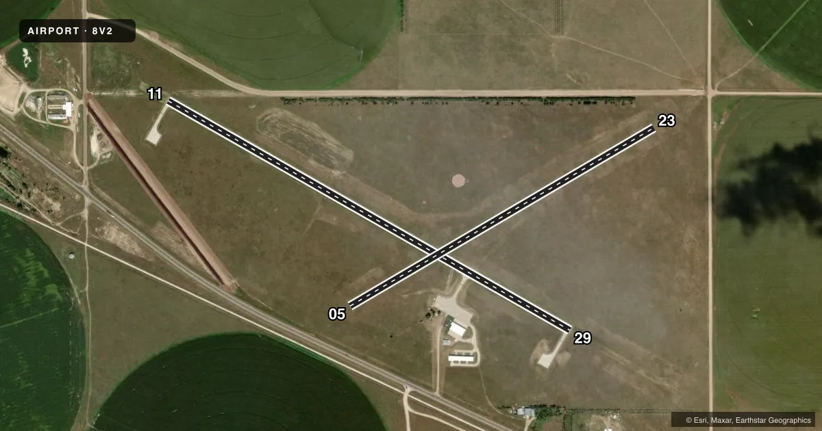
Runways & pattern
Full pagePattern entry · RWY 05
LEFT TRAFFIC| Runway | Heading (°M) | Length | Surface | Traffic |
|---|---|---|---|---|
| 11/29 | 114° / 294° | 3,900 ft | CONC | Standard L |
| 05/23Favored | 54° / 234° | 2,970 ft | TURF | Standard L |
Runway end performance
| End | TORA | TODA | ASDA | LDA | VGSI | Approach lights | Obstruction |
|---|---|---|---|---|---|---|---|
| 11 | — | — | — | — | PAPI 2-box left(3°) | — | — |
| 29 | — | — | — | — | PAPI 2-box left(3°) | — | — |
Declared distances in feet. TORA = takeoff run available, TODA = takeoff distance, ASDA = accelerate-stop, LDA = landing distance.
Airport sketch
Runways drawn to scale from FAA survey coordinates, rendered over satellite imagery. Not for navigation.
Approaches & charts
Services on the field
Fuel grades, oxygen, maintenance, ramp storage and lighting — as declared to the FAA by the airport operator.
Fuel & services
- Fuel
- 100LL
- Oxygen (bottled)
- Not available
- Oxygen (bulk)
- Not available
- Airframe repair
- Not available
- Power plant repair
- Not available
- Other services
- AGRI
Ramp & ground
- Transient storage
- Tie-down
- Landing fee
- No fee published
- Customs
- Not available
- Lighting schedule
- SEE RMK
- Beacon schedule
- SS-SR
- Beacon
- White / Green (civil land)(WG)
- Wind indicator
- Lighted
- Segmented circle
- Yes
Fuel & FBOs
Cheapest 100LL and Jet A on the field and nearby. Always confirm with the FBO before taxi.
Airport notes
Surface conditions, obstructions, local procedures, lighting outages and other notes published with each FAA cycle.
General notes
- FOR CD CTC MINNEAPOLIS ARTCC AT 651-463-5588.
Lighting notes
- ACTVT REIL RWY 11 & 29; PAPI RWY 11/29; MIRL RWY 11/29 PRESET MED INTST SS-SR, TO INCR INTST & ACTVT- CTAF.
Fuel notes
- 100LLFOR FUEL CALL (402) 925-5527 OR (402) 340-0388.
Runway surface & condition
- 05/23NARROWED TO 100', CENTERLINE STAYED THE SAME.
Approach & departure obstructions
- 05NSTD MKGS RY 05/23 MARKED WITH YELLOW CONES.
Other notes
- PROVIDED THAT THE APCH TO EACH RWY IS MAINTAINED FOR A MINIMUM 20:1 GLIDE SLOPE AND THE TRANSITIONAL SURFACE BE MAINTAINED FOR A 7:1 SLOPE.
VFR map & nearby airports
VFR sectional. Tap any ICAO chip to open that airport.
Key facts · 8V2
Answer card- ICAO
- 8V2
- Name
- STUART-ATKINSON MUNI
- Location
- ATKINSON, NEBRASKA
- Elevation
- 2,131 ft MSL
- Traffic pattern altitude
- 3,131 ft MSL (1,000 AGL)
- Control tower
- Non-towered (use CTAF)
- Total runways
- 2
- Longest runway
- 11/29 · 3,900 ft
- Published ILS approaches
- 0
- Published frequencies
- 1
- Magnetic variation
- 6°
- Current flight rules
- VFR
- Current wind
- 040° at 13 kt
- Favored runway now
- RWY 05
Stuart-Atkinson Muni sits in Atkinson, Nebraska. Field elevation is 2,131 ft MSL. The airport has two runways. The longest is 11/29 at 3,900 ft of concrete. Runway 05/23 is turf and 2,970 ft long. There is no control tower. CTAF is 122.9.
No ILS approaches are published here. Pattern altitude is not published, so use the standard 1,000 ft AGL pattern unless local guidance says otherwise. That puts the light piston pattern at 3,131 ft MSL based on the field elevation. Runway 11 and 29 have runway end identifier lights. They also have PAPI and medium intensity edge lights that can be adjusted on CTAF from sunset to sunrise.
There are no on-field FBOs listed. For 100LL, call the numbers in the Chart Supplement before you go. Runway 05/23 has nonstandard markings with yellow cones. It is also narrowed to 100 feet, with the centerline unchanged. Clearance delivery is handled through Minneapolis ARTCC at 651-463-5588. The published surface notes also call out a 20 to 1 glide slope surface and a 7 to 1 transitional surface, so keep your approach path clean and stay alert for obstacle clearance issues near the field.