METAR & TAF 8D8
8D8 does not publish a METAR.
Showing the nearest reporting station: KAGZ (WAGNER MUNI) · 11.8 NM away. Conditions at 8D8 may differ.
METAR · KAGZ
Observed 17:15Z
KAGZ 271715Z AUTO 06009KT 10SM CLR 33/21 A2987 RMK AO2
- Wind
- 060° @ 9 kt
- Visibility
- 10 SM
- Temp / Dew
- 33°C / 21°C
- Altimeter
- 29.87 inHg
- Clouds
- CLR
- Density alt
- 4,051 ft
- Ceiling
- Unlimited
- Rules
- VFR
Airport info & contacts
Manager on record, flight service, ARTCC, attendance schedule and pattern altitude — published by the FAA and refreshed every 28 days.
Location
- From city
- 1 NM S
- VFR sectional
- OMAHA
- ARTCC
- ZMP · MINNEAPOLIS
- NOTAM facility
- HON (NOTAM-D)
Airport manager
- Name
- RYAN FREDERICK
- Phone
- 605-487-7694
- Address
- PO BOX 783, LAKE ANDES SD 57356
Flight service · Hours
- FSS HON
- HURON1-800-WX-BRIEF
- Attendance
- Unattended
Frequencies
Tap any row to copy the frequency to your clipboard.
Runways & pattern
Full pagePattern entry · RWY 12
LEFT TRAFFICRunway end performance
| End | TORA | TODA | ASDA | LDA | VGSI | Approach lights | Obstruction |
|---|---|---|---|---|---|---|---|
| 12 | — | — | — | — | — | — | 17', road, 410' from thr, 0' R of cntrln, slope 24 |
| 30 | — | — | — | — | — | — | 115', pline, 4000' from thr, 0' R of cntrln, slope 34 |
Declared distances in feet. TORA = takeoff run available, TODA = takeoff distance, ASDA = accelerate-stop, LDA = landing distance.
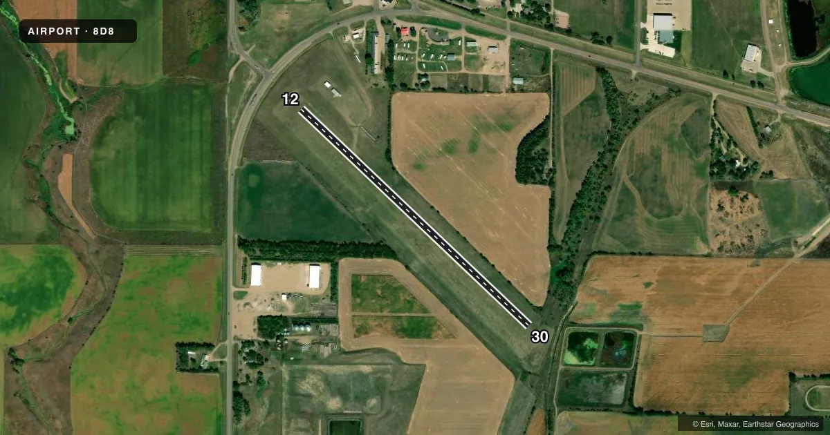
Airport sketch
Runways drawn to scale from FAA survey coordinates, rendered over satellite imagery. Not for navigation.
Approaches & charts
Services on the field
Fuel grades, oxygen, maintenance, ramp storage and lighting — as declared to the FAA by the airport operator.
Fuel & services
- Fuel
- Not available
- Oxygen (bottled)
- Not available
- Oxygen (bulk)
- Not available
- Airframe repair
- Not available
- Power plant repair
- Not available
Ramp & ground
- Transient storage
- Tie-down
- Landing fee
- No fee published
- Customs
- Not available
- Wind indicator
- Yes
- Segmented circle
- Yes
Fuel & FBOs
Cheapest 100LL and Jet A on the field and nearby. Always confirm with the FBO before taxi.
Airport notes
Surface conditions, obstructions, local procedures, lighting outages and other notes published with each FAA cycle.
General notes
- ARPT CLSD FOR NIGHT OPNS.
- WILDLIFE ON AND INVOF ARPT.
- AIRPORT CLSD DURING WINTER MONTHS.
- FOR CD CTC MINNEAPOLIS ARTCC AT 651-463-5588.
Approach & departure obstructions
- 12RWY MKD WITH BLACK/W CONES.
- 30RWY MKD WITH BLACK/W CONES.
VFR map & nearby airports
VFR sectional. Tap any ICAO chip to open that airport.
Key facts · 8D8
Answer card- ICAO
- 8D8
- Name
- LAKE ANDES MUNI
- Location
- LAKE ANDES, SOUTH DAKOTA
- Elevation
- 1,475 ft MSL
- Traffic pattern altitude
- 2,475 ft MSL (1,000 AGL)
- Control tower
- Non-towered (use CTAF)
- Total runways
- 1
- Longest runway
- 12/30 · 2,600 ft
- Published ILS approaches
- 0
- Published frequencies
- 1
- Magnetic variation
- 7°
- Current flight rules
- VFR
- Current wind
- 060° at 9 kt
- Favored runway now
- RWY 12
Lake Andes Muni sits in Lake Andes, South Dakota. Field elevation is 1,475 ft MSL. This is a non-towered airport with one runway. Runway 12/30 is 2,600 ft of turf, which makes it a short-field stop for light piston traffic. No ILS approaches are published. The pattern altitude is not published, so plan on the standard 1,000 ft AGL unless the current FAA Chart Supplement says otherwise.
The field is closed for night operations. It is also closed during the winter months. Wildlife is present on and near the airport, so keep a sharp scan on taxi, takeoff and landing. Runway 12 and Runway 30 are marked with black and white cones. CTAF is 122.9.
There are no on-field FBOs listed. Check with the airport operator or the FBO directly by phone before arrival if you need current services. For clearance delivery, contact Minneapolis ARTCC at 651-463-5588. If you are planning a trip here, verify current field status in the FAA Chart Supplement before you go. This is especially important because of the published night closure. It is also important because of the winter closure.