METAR & TAF 6A6
6A6 does not publish a METAR.
Showing the nearest reporting station: KMHE (MITCHELL MUNI) · 40.8 NM away. Conditions at 6A6 may differ.
METAR · KMHE
Observed 03:53Z
KMHE 260353Z AUTO 00000KT 10SM FEW110 24/21 A2988 RMK AO2 LTG DSNT E AND SE RAE42 SLP106 P0002 T02440211 $
- Wind
- 000° @ 0 kt
- Visibility
- 10 SM
- Temp / Dew
- 24°C / 21°C
- Altimeter
- 29.88 inHg
- Clouds
- FEW
- Density alt
- 3,306 ft
- Ceiling
- Unlimited
- Rules
- VFR
Airport info & contacts
Manager on record, flight service, ARTCC, attendance schedule and pattern altitude — published by the FAA and refreshed every 28 days.
Location
- From city
- 2 NM NW
- VFR sectional
- OMAHA
- ARTCC
- ZMP · MINNEAPOLIS
- NOTAM facility
- HON (NOTAM-D)
Airport manager
- Name
- CITY OF KIMBALL
- Phone
- 605-682-8042
- Address
- C/O CITY OF KIMBALL, PO BOX 16, KIMBALL SD 57355-0016
Flight service · Hours
- FSS HON
- HURON1-800-WX-BRIEF
- Attendance
- Unattended
Frequencies
Tap any row to copy the frequency to your clipboard.
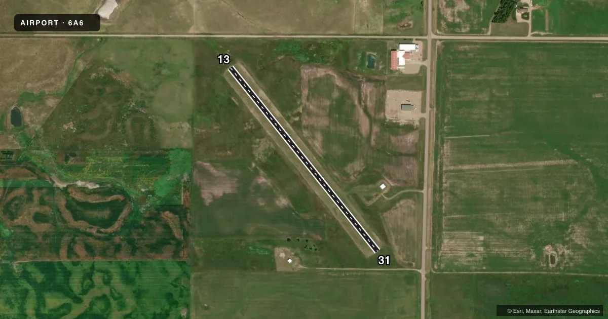
Runways & pattern
Full pagePattern entry · RWY 13
LEFT TRAFFICRunway end performance
| End | TORA | TODA | ASDA | LDA | VGSI | Approach lights | Obstruction |
|---|---|---|---|---|---|---|---|
| 13 | — | — | — | — | — | — | 16', road, 320' from thr, 0' R of cntrln, slope 20 |
| 31 | — | — | — | — | — | — | 25', road, 500' from thr, 0' R of cntrln, slope 20 |
Declared distances in feet. TORA = takeoff run available, TODA = takeoff distance, ASDA = accelerate-stop, LDA = landing distance.
Airport sketch
Runways drawn to scale from FAA survey coordinates, rendered over satellite imagery. Not for navigation.
Approaches & charts
Services on the field
Fuel grades, oxygen, maintenance, ramp storage and lighting — as declared to the FAA by the airport operator.
Fuel & services
- Fuel
- Not available
- Oxygen (bottled)
- Not available
- Oxygen (bulk)
- Not available
- Airframe repair
- Not available
- Power plant repair
- Not available
- Other services
- AGRI
Ramp & ground
- Transient storage
- Not published
- Landing fee
- No fee published
- Customs
- Not available
- Wind indicator
- Yes
- Segmented circle
- No
Fuel & FBOs
Cheapest 100LL and Jet A on the field and nearby. Always confirm with the FBO before taxi.
Airport notes
Surface conditions, obstructions, local procedures, lighting outages and other notes published with each FAA cycle.
General notes
- FOR CD CTC MINNEAPOLIS ARTCC AT 651-463-5588.
- ARPT CLSD FOR NIGHT OPNS.
Approach & departure obstructions
- 13RWY MKD WITH WHITE & BLACK CONES.
- 31RWY MKD WITH WHITE & BLACK CONES.
VFR map & nearby airports
VFR sectional. Tap any ICAO chip to open that airport.
Key facts · 6A6
Answer card- ICAO
- 6A6
- Name
- KIMBALL MUNI
- Location
- KIMBALL, SOUTH DAKOTA
- Elevation
- 1,755 ft MSL
- Traffic pattern altitude
- 2,755 ft MSL (1,000 AGL)
- Control tower
- Non-towered (use CTAF)
- Total runways
- 1
- Longest runway
- 13/31 · 2,625 ft
- Published ILS approaches
- 0
- Published frequencies
- 1
- Magnetic variation
- 8°
- Current flight rules
- VFR
- Current wind
- 000° at 0 kt
- Favored runway now
- –
KIMBALL MUNI sits in Kimball, South Dakota. The field elevation is 1,755 ft MSL. It has one runway, 13/31, at 2,625 ft of turf. There is no control tower. CTAF is 122.9.
No ILS approaches are published here. Pattern altitude is not published, so use the standard 1,000 ft AGL unless the current Chart Supplement says otherwise. The airport is closed for night operations. That matters here. Plan your arrival in daylight. Verify your timing before launch.
Runway 13 and runway 31 are both marked with white and black cones. That is a useful visual cue on a turf strip. Clearance delivery, when needed, is handled through Minneapolis ARTCC at 651-463-5588. There are no on-field FBOs listed. Contact the airport operator directly before arrival if you need services. For a first visit, the main things to watch are the turf surface, the single short runway and the lack of published instrument approach support. Check the current FAA Chart Supplement before you go.