METAR & TAF 9V9
Current METAR
Observed 12:55Z
K9V9 271255Z AUTO 02007KT 10SM CLR 26/24 A2988 RMK AO2 T02610235
- Wind
- 020° @ 7 kt
- Visibility
- 10 SM
- Temp / Dew
- 26°C / 24°C
- Altimeter
- 29.88 inHg
- Clouds
- CLR
- Density alt
- 3,473 ft
- Ceiling
- Unlimited
- Rules
- VFR
Airport info & contacts
Manager on record, flight service, ARTCC, attendance schedule and pattern altitude — published by the FAA and refreshed every 28 days.
Location
- From city
- 3 NM S
- VFR sectional
- OMAHA
- ARTCC
- ZMP · MINNEAPOLIS
- NOTAM facility
- 9V9 (NOTAM-D)
Airport manager
- Name
- DUSTEN HRABE
- Phone
- 605-680-9935
- Address
- 101 AIRPORT ROAD, CHAMBERLAIN SD 57325
Flight service · Hours
- FSS HON
- HURON1-800-WX-BRIEF
- Attendance
- ALL
Frequencies
Tap any row to copy the frequency to your clipboard.
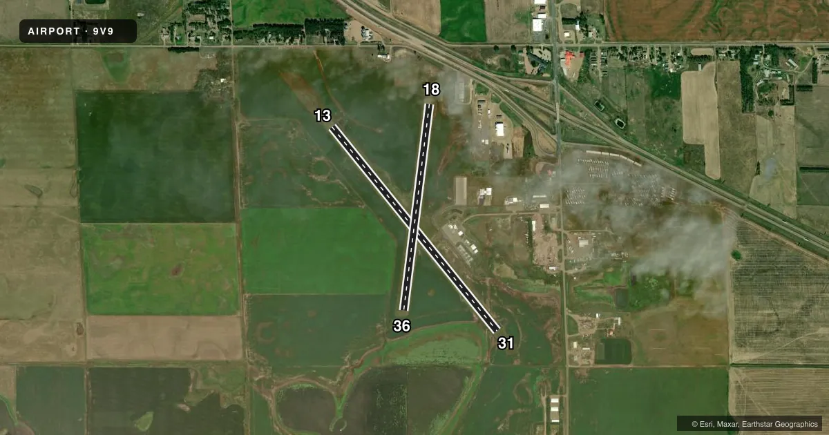
Runways & pattern
Full pagePattern entry · RWY 36
LEFT TRAFFIC| Runway | Heading (°M) | Length | Surface | Traffic |
|---|---|---|---|---|
| 13/31 | 136° / 316° | 4,299 ft | ASPH | Standard L |
| 18/36Favored | 182° / 2° | 3,403 ft | TURF | Standard L |
Runway end performance
| End | TORA | TODA | ASDA | LDA | VGSI | Approach lights | Obstruction |
|---|---|---|---|---|---|---|---|
| 13 | — | — | — | — | PAPI 2-box left(3°) | — | 64', tree, 1539' from thr, 415' R of cntrln, slope 20 |
| 31 | — | — | — | — | PAPI 2-box left(3°) | — | — |
| 18 | — | — | — | — | — | — | 46', pole, 1000' from thr, 0' R of cntrln, slope 21 |
Declared distances in feet. TORA = takeoff run available, TODA = takeoff distance, ASDA = accelerate-stop, LDA = landing distance.
Airport sketch
Runways drawn to scale from FAA survey coordinates, rendered over satellite imagery. Not for navigation.
Approaches & charts
Services on the field
Fuel grades, oxygen, maintenance, ramp storage and lighting — as declared to the FAA by the airport operator.
Fuel & services
- Fuel
- 100LLA
- Airframe repair
- Minor
- Power plant repair
- Minor
- Other services
- AGRI
Ramp & ground
- Transient storage
- Tie-down
- Hangar
- Landing fee
- No fee published
- Lighting schedule
- SEE RMK
- Beacon schedule
- SS-SR
- Beacon
- White / Green (civil land)(WG)
- Wind indicator
- Lighted
- Segmented circle
- Yes
Fuel & FBOs
Cheapest 100LL and Jet A on the field and nearby. Always confirm with the FBO before taxi.
Airport notes
Surface conditions, obstructions, local procedures, lighting outages and other notes published with each FAA cycle.
General notes
- WATERFOWL ON & INVOF ARPT.
- GCO AVBL ON FREQ 121.725 ( 4 CLICKS TO MINNEAPOLIS CENTER AND 6 CLIKCS TO FLIGHT SERVICES)
- FOR CD IF UNA VIA GCO CTC MINNEAPOLIS ARTCC AT 651-463-5588.
Lighting notes
- MIRL RY 13/31 PRESET ON LOW INTST, TO INCR INTST & ACTVT PAPI RYS 13 & 31 - CTAF.
Fuel notes
- 100LLFUEL AVBL 24 HRS WITH CREDIT CARD.
Approach & departure obstructions
- 18MKD WITH WHITE/BLACK TIPPED MKR CONES.
- 36MKD WITH WHITE/BLACK TIPPED MKR CONES.
VFR map & nearby airports
VFR sectional. Tap any ICAO chip to open that airport.
Key facts · 9V9
Answer card- ICAO
- 9V9
- Name
- CHAMBERLAIN MUNI
- Location
- CHAMBERLAIN, SOUTH DAKOTA
- Elevation
- 1,696.3 ft MSL
- Traffic pattern altitude
- 2,696.3 ft MSL (1,000 AGL)
- Control tower
- Non-towered (use CTAF)
- Total runways
- 2
- Longest runway
- 13/31 · 4,299 ft
- Published ILS approaches
- 0
- Published frequencies
- 2
- Magnetic variation
- 5°
- Current flight rules
- VFR
- Current wind
- 020° at 7 kt
- Favored runway now
- RWY 36
Chamberlain Muni sits in Chamberlain, South Dakota. The field elevation is 1,696.3 ft MSL. It has two runways. The longest is runway 13/31 at 4,299 ft. The airport is non-towered. CTAF and UNICOM are both 122.8.
No ILS approaches are published here. Pattern altitude is not published, so use the standard 1,000 ft AGL pattern unless the current Chart Supplement says otherwise. The on-field FBO is Chamberlain Municipal Airport. It carries 100LL and Jet A. Fuel is available 24 hours with a credit card.
A few operational notes matter here. Runway 13/31 lights are preset to low intensity. Use CTAF to increase the lighting intensity and to activate the PAPI on 13 and 31. A ground communications outlet is available on 121.725. Waterfowl are reported on and near the airport, so keep a sharp scan on approach and in the pattern. Runway 18 and runway 36 are marked with white and black tipped marker cones. If you need clearance delivery and the ground outlet is not available, contact Minneapolis ARTCC. For any current noise or local operating restrictions, check the current FAA Chart Supplement before you go.