METAR & TAF 5P5
5P5 does not publish a METAR.
Showing the nearest reporting station: KPIR (PIERRE RGNL) · 30.6 NM away. Conditions at 5P5 may differ.
METAR · KPIR
Observed 17:53Z
KPIR 241753Z AUTO 18011G17KT 10SM CLR 32/20 A2988 RMK AO2 SLP102 T03170200 10317 20167 58010
- Wind
- 180° @ 11G17 kt
- Visibility
- 10 SM
- Temp / Dew
- 32°C / 20°C
- Altimeter
- 29.88 inHg
- Clouds
- CLR
- Density alt
- 4,272 ft
- Ceiling
- Unlimited
- Rules
- VFR
Airport info & contacts
Manager on record, flight service, ARTCC, attendance schedule and pattern altitude — published by the FAA and refreshed every 28 days.
Location
- From city
- 1 NM E
- VFR sectional
- OMAHA
- ARTCC
- ZMP · MINNEAPOLIS
- NOTAM facility
- HON (NOTAM-D)
Airport manager
- Name
- DUSTIN SMITH
- Phone
- 605-280-4641
- Address
- 30328 248TH ST, PRESHO SD 57568
Flight service · Hours
- FSS HON
- HURON1-800-WX-BRIEF
- Attendance
- Unattended
Frequencies
Tap any row to copy the frequency to your clipboard.
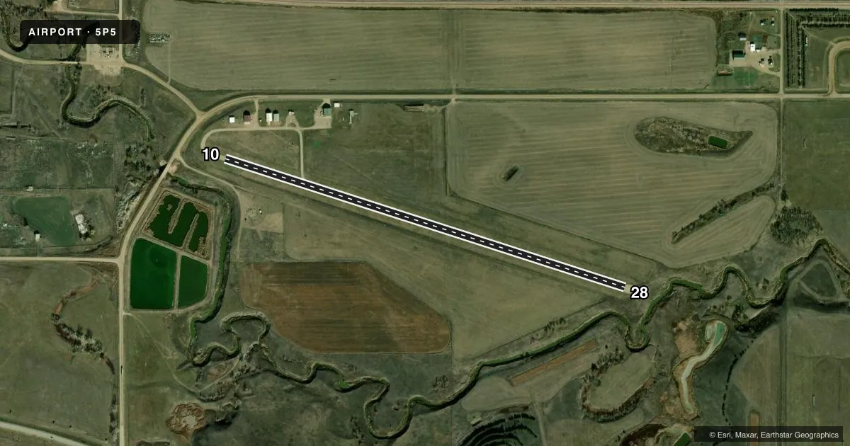
Runways & pattern
Full pagePattern entry · RWY 10
LEFT TRAFFICRunway end performance
| End | TORA | TODA | ASDA | LDA | VGSI | Approach lights | Obstruction |
|---|---|---|---|---|---|---|---|
| 10 | — | — | — | — | — | — | 15', road, 300' from thr, 0' R of cntrln, slope 20 |
| 28 | — | — | — | — | — | — | 4', fence, 110' from thr, 0' R of cntrln, slope 27 |
Declared distances in feet. TORA = takeoff run available, TODA = takeoff distance, ASDA = accelerate-stop, LDA = landing distance.
Airport sketch
Runways drawn to scale from FAA survey coordinates, rendered over satellite imagery. Not for navigation.
Approaches & charts
Services on the field
Fuel grades, oxygen, maintenance, ramp storage and lighting — as declared to the FAA by the airport operator.
Fuel & services
- Fuel
- Not available
- Oxygen (bottled)
- Not available
- Oxygen (bulk)
- Not available
- Airframe repair
- Not available
- Power plant repair
- Not available
- Other services
- AGRI,INSTR
Ramp & ground
- Transient storage
- Tie-down
- Landing fee
- No fee published
- Customs
- Not available
- Lighting schedule
- SEE RMK
- Beacon schedule
- SS-SR
- Beacon
- White / Green (civil land)(WG)
- Wind indicator
- Lighted
- Segmented circle
- No
Fuel & FBOs
Cheapest 100LL and Jet A on the field and nearby. Always confirm with the FBO before taxi.
Airport notes
Surface conditions, obstructions, local procedures, lighting outages and other notes published with each FAA cycle.
General notes
- WILDLIFE & WATERFOWL ON & INVOF ARPT.
- FOR CD CTC MINNEAPOLIS ARTCC AT 651-463-5588.
Lighting notes
- ACTVT LIRL RY 10/28 - CTAF.
Approach & departure obstructions
- 1010/28 MKD WITH BLACK AND WHITE CONES.
Other notes
- 10/28CNTR 52 FT GRAVEL PLUS GRAVEL TURNAROUNDS.
VFR map & nearby airports
VFR sectional. Tap any ICAO chip to open that airport.
Key facts · 5P5
Answer card- ICAO
- 5P5
- Name
- PRESHO MUNI
- Location
- PRESHO, SOUTH DAKOTA
- Elevation
- 1,760 ft MSL
- Traffic pattern altitude
- 2,760 ft MSL (1,000 AGL)
- Control tower
- Non-towered (use CTAF)
- Total runways
- 1
- Longest runway
- 10/28 · 3,350 ft
- Published ILS approaches
- 0
- Published frequencies
- 1
- Magnetic variation
- 9°
- Current flight rules
- VFR
- Current wind
- 180° at 11 kt
- Favored runway now
- RWY 10
Presho Muni sits in Presho, South Dakota. The field elevation is 1,760 ft MSL. It has one runway. Runway 10/28 is 3,350 ft long. The airport is non-towered. CTAF is 122.9.
No ILS approaches are published here. Pattern altitude is not published in the facts. Use the standard 1,000 ft AGL pattern unless the current Chart Supplement says otherwise. The runway surface is turf-gravel. The center 52 ft of runway 10/28 is gravel. There are also gravel turnarounds. Runway 10 and runway 28 are marked with black and white cones. Low intensity runway lights on 10/28 are activated by CTAF.
Wildlife and waterfowl are reported on and near the airport. That is the main operational item to watch for on arrival and departure. For clearance delivery, contact Minneapolis ARTCC at 651-463-5588. There are no on-field FBOs listed in the facts. Verify services with the airport operator or call the field directly before you go. With one short turf-gravel runway and no published ILS, this is a simple VFR field that still deserves a close look at surface condition, winds and bird activity before you commit.