METAR & TAF KPIR
Current METAR
Observed 12:53Z
KPIR 271253Z AUTO 05008KT 6SM HZ CLR 24/16 A2985 RMK AO2 SLP088 T02390161
- Wind
- 050° @ 8 kt
- Visibility
- 6 SM
- Temp / Dew
- 24°C / 16°C
- Altimeter
- 29.85 inHg
- Clouds
- CLR
- Density alt
- 3,330 ft
- Ceiling
- Unlimited
- Rules
- VFR
Airport info & contacts
Manager on record, flight service, ARTCC, attendance schedule and pattern altitude — published by the FAA and refreshed every 28 days.
Location
- From city
- 3 NM E
- VFR sectional
- OMAHA
- ARTCC
- ZMP · MINNEAPOLIS
- NOTAM facility
- PIR (NOTAM-D)
Airport manager
- Name
- CASEY PAMPERIEN
- Phone
- 605-773-7447
- Address
- 3800 AIRPORT ROAD, SUITE 209, PIERRE SD 57501
Flight service · Hours
- FSS HON
- HURON1-800-WX-BRIEF
- Attendance
- MON-FRI · 0500-2400
- SAT-SUN · 0500-2200
Frequencies
Tap any row to copy the frequency to your clipboard.
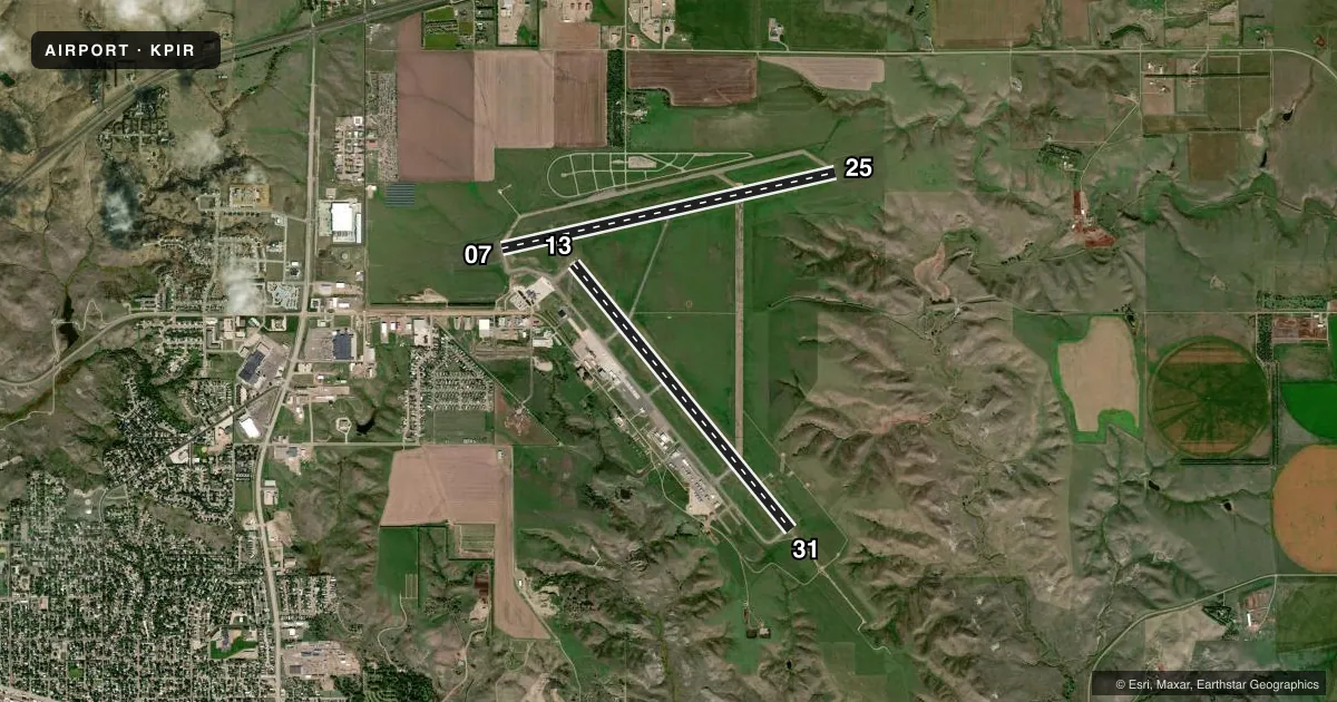
Runways & pattern
Full pagePattern entry · RWY 07
LEFT TRAFFIC| Runway | Heading (°M) | Length | Surface | Traffic |
|---|---|---|---|---|
| 13/31 | 133° / 313° | 6,900 ft | ASPH | Standard L |
| 07/25Favored | 69° / 249° | 6,880 ft | ASPH | Standard L |
Runway end performance
| End | TORA | TODA | ASDA | LDA | VGSI | Approach lights | Obstruction |
|---|---|---|---|---|---|---|---|
| 13 | 6,900' | 6,900' | 6,900' | 6,900' | PAPI 4-box left(3°) | — | — |
| 31 | 6,900' | 6,900' | 6,900' | 6,900' | PAPI 4-box left(3°) | MALSR | — |
| 07 | 6,880' | 6,880' | 6,880' | 6,880' | PAPI 4-box left(3°) | — | 79', tank, 3158' from thr, 548' R of cntrln, slope 37 |
| 25 | 6,880' | 6,880' | 6,880' | 6,880' | PAPI 4-box left(3°) | — | — |
Declared distances in feet. TORA = takeoff run available, TODA = takeoff distance, ASDA = accelerate-stop, LDA = landing distance.
Airport sketch
Runways drawn to scale from FAA survey coordinates, rendered over satellite imagery. Not for navigation.
Approaches & charts
ILS · 1
Services on the field
Fuel grades, oxygen, maintenance, ramp storage and lighting — as declared to the FAA by the airport operator.
Fuel & services
- Fuel
- 100LLA
- Oxygen (bottled)
- HIGH/LOW
- Oxygen (bulk)
- HIGH/LOW
- Airframe repair
- Major
- Power plant repair
- Major
- Other services
- AFRT,AGRI,AMB,CHTR,INSTR,RNTL,SALES
Ramp & ground
- Transient storage
- Tie-down
- Hangar
- Landing fee
- No fee published
- Customs
- Not available
- Lighting schedule
- SEE RMK
- Beacon schedule
- SS-SR
- Beacon
- White / Green (civil land)(WG)
- Wind indicator
- Lighted
- Segmented circle
- Yes
Fuel & FBOs
Cheapest 100LL and Jet A on the field and nearby. Always confirm with the FBO before taxi.
Airport notes
Surface conditions, obstructions, local procedures, lighting outages and other notes published with each FAA cycle.
General notes
- ARPT COND UNMON AT NGT FM LAST ACR ARR/DEP TILL 0500 LCL.
- CLASS I, ARFF INDEX B. ARFF COVERAGE PRVDD DURG SKED ACR OPS; 24 HRS PPR FOR UNSKED ACR OPS WITH MORE THAN 30 PSGR SEATS CALL ARPT OPS 605-773-7476/7405.
- TWY C IS 50 FT WIDE & RESTRD TO ACFT 75000 POUNDS OR LESS.
- NO LINE OF SIGHT BTN RWY ENDS OF RWY 07 & 25.
- BIRDS ON & INVOF ARPT AND WI 25 NM RADIUS.
- NOTE: SEE SPECIAL NOTICES SECTION & AEROBATIC PRACTICE AREAS.
- FOR CD IF UNA TO CTC ON FREQ, CTC MINNEAPOLIS ARTCC AT 651-463-5588.
- ATND DLY 1200-0400Z; FOR ATTENDANT OTR TIMES CALL 605-224-9000.
Lighting notes
- ACTVT MALSR RWY 31; REIL RWY 07, 13, 25; PAPI RWY 07, 25, 13 & 31; HIRL RWY 07/25 & 13/31 -CTAF.
Runway surface & condition
- 07/25PCR VALUE: 515/F/D/X/T
- 13/31PCR VALUE: 421/F/D/W/T
Other notes
- 48 HOUR PPR FOR UNSKED ACR OPNS INVOLVING ACFT DESIGNED FOR 31 OR MORE PAX SEATS CALL 605-773-7447 OR 605-773-7405.
- NO
VFR map & nearby airports
VFR sectional. Tap any ICAO chip to open that airport.
Key facts · KPIR
Answer card- ICAO
- KPIR
- Name
- PIERRE RGNL
- Location
- PIERRE, SOUTH DAKOTA
- Elevation
- 1,744.3 ft MSL
- Traffic pattern altitude
- 2,744.3 ft MSL (1,000 AGL)
- Control tower
- Non-towered (use CTAF)
- Total runways
- 2
- Longest runway
- 13/31 · 6,900 ft
- Published ILS approaches
- 1
- Published frequencies
- 2
- Magnetic variation
- 8°
- Current flight rules
- VFR
- Current wind
- 050° at 8 kt
- Favored runway now
- RWY 07
Pierre Rgnl sits in Pierre, South Dakota. The field elevation is 1,744.3 ft MSL. It has two asphalt runways. The longest is runway 13/31 at 6,900 ft. There is no control tower, so plan to use CTAF 122.7 and UNICOM 122.95 for local traffic work.
An ILS is available for runway 31. Published pattern altitude is not listed, so use the standard 1,000 ft AGL for light piston operations unless the current Chart Supplement says otherwise. Mustang Aviation is on the field. It carries 100LL and Jet A Prist. The airport notes birds in and around the field within 25 NM. It also says airport condition is unmonitored at night from the last arrival or departure until 0500 local, so give the runway and taxiways a careful look on late arrivals.
The field has no landing fee. Taxiway C is limited to aircraft at or below 75,000 lb. Runway 07/25 has no line of sight between the ends. That matters for self-announcing traffic. There is also a note to check special notices and aerobatic practice areas before you go. For unscheduled larger aircraft operations, the published prior permission rules apply. Call airport operations if that affects your flight.