METAR & TAF 84D
84D does not publish a METAR.
Showing the nearest reporting station: KMBG (MOBRIDGE MUNI) · 49.1 NM away. Conditions at 84D may differ.
METAR · KMBG
Observed 13:28Z
KMBG 271328Z AUTO 31003KT 5SM HZ CLR 23/16 A2988 RMK AO2 T02280156
- Wind
- 310° @ 3 kt
- Visibility
- 5 SM
- Temp / Dew
- 23°C / 16°C
- Altimeter
- 29.88 inHg
- Clouds
- CLR
- Density alt
- 4,046 ft
- Ceiling
- Unlimited
- Rules
- MVFR
Airport info & contacts
Manager on record, flight service, ARTCC, attendance schedule and pattern altitude — published by the FAA and refreshed every 28 days.
Location
- From city
- 1 NM S
- VFR sectional
- BILLINGS
- ARTCC
- ZMP · MINNEAPOLIS
- NOTAM facility
- HON (NOTAM-D)
Airport manager
- Name
- JAMES TRAVERSIE
- Phone
- 605-964-8783
- Address
- PO BOX 150, EAGLE BUTTE SD 57636
Flight service · Hours
- FSS HON
- HURON1-800-WX-BRIEF
- Attendance
- Unattended
Frequencies
Tap any row to copy the frequency to your clipboard.
Runways & pattern
Full pagePattern entry · RWY 31
LEFT TRAFFICRunway end performance
| End | TORA | TODA | ASDA | LDA | VGSI | Approach lights | Obstruction |
|---|---|---|---|---|---|---|---|
| 13 | — | — | — | — | PAPI 2-box left(3°) | — | 7', road, 470' from thr, 0' R of cntrln, slope 38 |
| 31 | — | — | — | — | PAPI 2-box left(3°) | — | — |
Declared distances in feet. TORA = takeoff run available, TODA = takeoff distance, ASDA = accelerate-stop, LDA = landing distance.
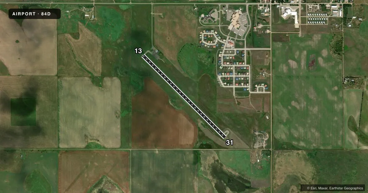
Airport sketch
Runways drawn to scale from FAA survey coordinates, rendered over satellite imagery. Not for navigation.
Approaches & charts
Services on the field
Fuel grades, oxygen, maintenance, ramp storage and lighting — as declared to the FAA by the airport operator.
Fuel & services
- Fuel
- Not available
- Other services
- AMB
Ramp & ground
- Transient storage
- Tie-down
- Hangar
- Landing fee
- No fee published
- Lighting schedule
- SEE RMK
- Beacon schedule
- SS-SR
- Beacon
- White / Green (civil land)(WG)
- Wind indicator
- Lighted
- Segmented circle
- No
Fuel & FBOs
Cheapest 100LL and Jet A on the field and nearby. Always confirm with the FBO before taxi.
Airport notes
Surface conditions, obstructions, local procedures, lighting outages and other notes published with each FAA cycle.
General notes
- WILDLIFE ON & INVOF ARPT.
- FOR CD CTC MINNEAPOLIS ARTCC AT 651-463-5588.
Lighting notes
- ACTVT PAPI RWY 13 & 31; MIRL RWY 13/31 - CTAF.
Other notes
- AUTOMATED UNICOM.
VFR map & nearby airports
VFR sectional. Tap any ICAO chip to open that airport.
Key facts · 84D
Answer card- ICAO
- 84D
- Name
- CHEYENNE EAGLE BUTTE
- Location
- EAGLE BUTTE, SOUTH DAKOTA
- Elevation
- 2,448.8 ft MSL
- Traffic pattern altitude
- 3,448.8 ft MSL (1,000 AGL)
- Control tower
- Non-towered (use CTAF)
- Total runways
- 1
- Longest runway
- 13/31 · 4,200 ft
- Published ILS approaches
- 0
- Published frequencies
- 2
- Magnetic variation
- 5°
- Current flight rules
- MVFR
- Current wind
- 310° at 3 kt
- Favored runway now
- RWY 31
Cheyenne Eagle Butte is in Eagle Butte, South Dakota. The field elevation is 2,448.8 ft MSL. It has one runway, 13/31, which is 4,200 ft long and paved asphalt. There is no control tower. CTAF and UNICOM are both 122.8. No ILS approaches are published here.
The pattern altitude is not published, so use standard 1,000 ft AGL unless the current Chart Supplement says otherwise. That puts the light piston pattern at about 3,448.8 ft MSL. Automated UNICOM is available. PAPI is available for runways 13 and 31. Medium intensity runway lights for 13 and 31 are activated on CTAF.
There are no on-field FBOs listed, so call the airport operator or the field directly before arrival if you need services. Wildlife is reported on and near the airport, so plan your taxi, takeoff and landing with that in mind. For clearance delivery, contact Minneapolis ARTCC at 651-463-5588. If you are arriving IFR or planning night operations, verify the current Chart Supplement before departure.