METAR & TAF 5P2
5P2 does not publish a METAR.
Showing the nearest reporting station: KMBG (MOBRIDGE MUNI) · 21.9 NM away. Conditions at 5P2 may differ.
METAR · KMBG
Observed 14:52Z
KMBG 271452Z AUTO 04008KT 8SM CLR 27/17 A2988 RMK AO2 SLP102 T02670167 50003
- Wind
- 040° @ 8 kt
- Visibility
- 8 SM
- Temp / Dew
- 27°C / 17°C
- Altimeter
- 29.88 inHg
- Clouds
- CLR
- Density alt
- 3,980 ft
- Ceiling
- Unlimited
- Rules
- VFR
Airport info & contacts
Manager on record, flight service, ARTCC, attendance schedule and pattern altitude — published by the FAA and refreshed every 28 days.
Location
- From city
- 2 NM SE
- VFR sectional
- TWIN CITIES
- ARTCC
- ZMP · MINNEAPOLIS
- NOTAM facility
- HON (NOTAM-D)
Airport manager
- Name
- NATE THOMPSON
- Phone
- 605-926-9101
- Address
- PO BOX 169, MCLAUGHLIN SD 57642
Flight service · Hours
- FSS HON
- HURON1-800-WX-BRIEF
- Attendance
- Unattended
Frequencies
Tap any row to copy the frequency to your clipboard.
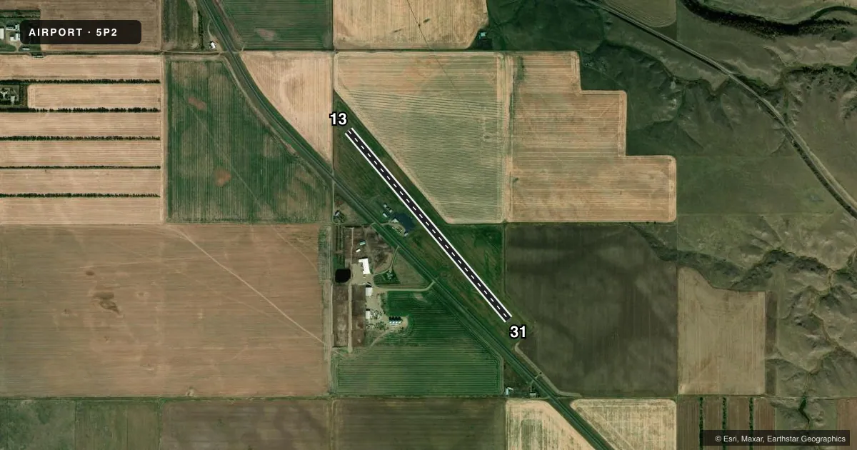
Runways & pattern
Full pagePattern entry · RWY 31
LEFT TRAFFICRunway end performance
| End | TORA | TODA | ASDA | LDA | VGSI | Approach lights | Obstruction |
|---|---|---|---|---|---|---|---|
| 13 | — | — | — | — | PAPI 2-box left(3°) | — | 1', fence, 220' from thr, 0' R of cntrln, slope 20 |
| 31 | — | — | — | — | PAPI 2-box left(3°) | — | — |
Declared distances in feet. TORA = takeoff run available, TODA = takeoff distance, ASDA = accelerate-stop, LDA = landing distance.
Airport sketch
Runways drawn to scale from FAA survey coordinates, rendered over satellite imagery. Not for navigation.
Approaches & charts
Services on the field
Fuel grades, oxygen, maintenance, ramp storage and lighting — as declared to the FAA by the airport operator.
Fuel & services
- Fuel
- 100LL
- Oxygen (bottled)
- Not available
- Oxygen (bulk)
- Not available
- Airframe repair
- Not available
- Power plant repair
- Not available
- Other services
- AGRI
Ramp & ground
- Transient storage
- Tie-down
- Landing fee
- No fee published
- Customs
- Not available
- Lighting schedule
- SEE RMK
- Beacon schedule
- SS-SR
- Beacon
- White / Green (civil land)(WG)
- Wind indicator
- Lighted
- Segmented circle
- Yes
Fuel & FBOs
Cheapest 100LL and Jet A on the field and nearby. Always confirm with the FBO before taxi.
Airport notes
Surface conditions, obstructions, local procedures, lighting outages and other notes published with each FAA cycle.
General notes
- FOR CD CTC MINNEAPOLIS ARTCC AT 651-463-5588.
Lighting notes
- ACTVT MIRL RWY 13/31; PAPI RWY 13 & 31 - CTAF.
Fuel notes
- 100LLFOR FUEL CALL 605-926-9101 OR 605-230-1844.
VFR map & nearby airports
VFR sectional. Tap any ICAO chip to open that airport.
Key facts · 5P2
Answer card- ICAO
- 5P2
- Name
- MC LAUGHLIN MUNI
- Location
- MC LAUGHLIN, SOUTH DAKOTA
- Elevation
- 2,008 ft MSL
- Traffic pattern altitude
- 3,008 ft MSL (1,000 AGL)
- Control tower
- Non-towered (use CTAF)
- Total runways
- 1
- Longest runway
- 13/31 · 3,789 ft
- Published ILS approaches
- 0
- Published frequencies
- 2
- Magnetic variation
- 9°
- Current flight rules
- VFR
- Current wind
- 040° at 8 kt
- Favored runway now
- RWY 31
Mc Laughlin Muni sits in Mc Laughlin, South Dakota. Field elevation is 2,008 ft MSL. The airport has one runway. Runway 13/31 is 3,789 ft long with asphalt pavement. It is a non-towered field, so plan to self-announce on CTAF 122.8. UNICOM is also 122.8.
No ILS approaches are published here. Pattern altitude is not published in the facts. Use the standard 1,000 ft AGL pattern unless local guidance or the current Chart Supplement says otherwise. That puts the light-piston pattern at about 3,008 ft MSL.
Published remarks note that clearance delivery goes through Minneapolis ARTCC at 651-463-5588. They also note 100LL fuel contact numbers, so call ahead if fuel is part of your plan. Runway 13/31 has medium intensity lights. PAPI on both runway ends is activated by CTAF. That is useful for night or low-light arrivals.
For a first-time arrival, the main things to watch are the non-towered traffic flow, the field elevation and the lighting activation method. Check the current Chart Supplement for any updates before you go.