METAR & TAF D58
D58 does not publish a METAR.
Showing the nearest reporting station: KMBG (MOBRIDGE MUNI) · 29.6 NM away. Conditions at D58 may differ.
METAR · KMBG
Observed 04:52Z
KMBG 270452Z AUTO 01007KT 7SM OVC047 23/13 A2983 RMK AO2 SLP084 T02280133 $
- Wind
- 010° @ 7 kt
- Visibility
- 7 SM
- Temp / Dew
- 23°C / 13°C
- Altimeter
- 29.83 inHg
- Clouds
- OVC
- Density alt
- 3,791 ft
- Ceiling
- 4,700 ft AGL
- Rules
- VFR
Airport info & contacts
Manager on record, flight service, ARTCC, attendance schedule and pattern altitude — published by the FAA and refreshed every 28 days.
Location
- From city
- 1 NM SW
- VFR sectional
- BILLINGS
- ARTCC
- ZMP · MINNEAPOLIS
- NOTAM facility
- HON (NOTAM-D)
Airport manager
- Name
- JAKE KRAFT
- Phone
- 605-848-2624
- Address
- PO BOX 71, TIMBER LAKE SD 57656
Flight service · Hours
- FSS HON
- HURON1-800-WX-BRIEF
- Attendance
- DALGT
Frequencies
Tap any row to copy the frequency to your clipboard.
Runways & pattern
Full pagePattern entry · RWY 30
LEFT TRAFFICRunway end performance
| End | TORA | TODA | ASDA | LDA | VGSI | Approach lights | Obstruction |
|---|---|---|---|---|---|---|---|
| 30 | — | — | — | — | — | — | 17', road, 370' from thr, 160' R of cntrln, slope 21 |
Declared distances in feet. TORA = takeoff run available, TODA = takeoff distance, ASDA = accelerate-stop, LDA = landing distance.
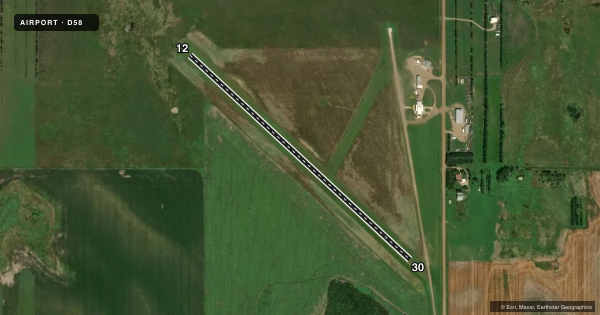
Airport sketch
Runways drawn to scale from FAA survey coordinates, rendered over satellite imagery. Not for navigation.
Approaches & charts
Services on the field
Fuel grades, oxygen, maintenance, ramp storage and lighting — as declared to the FAA by the airport operator.
Fuel & services
- Fuel
- Not available
- Oxygen (bottled)
- Not available
- Oxygen (bulk)
- Not available
- Airframe repair
- Minor
- Power plant repair
- Minor
- Other services
- AGRI,INSTR
Ramp & ground
- Transient storage
- Hangar
- Landing fee
- No fee published
- Customs
- Not available
- Wind indicator
- Yes
- Segmented circle
- No
Fuel & FBOs
Cheapest 100LL and Jet A on the field and nearby. Always confirm with the FBO before taxi.
Airport notes
Surface conditions, obstructions, local procedures, lighting outages and other notes published with each FAA cycle.
General notes
- RY 12 FENCE 180 FT FROM THR; TOP OF FENCE BLO ELEV OF RY.
- FOR FLD CONDS CALL AMGR 605-848-2624.
- WILDLIFE ON AND INVOF ARPT.
- FOR CD CTC MINNEAPOLIS ARTCC AT 651-463-5588.
VFR map & nearby airports
VFR sectional. Tap any ICAO chip to open that airport.
Key facts · D58
Answer card- ICAO
- D58
- Name
- TIMBER LAKE MUNI
- Location
- TIMBER LAKE, SOUTH DAKOTA
- Elevation
- 2,193 ft MSL
- Traffic pattern altitude
- 3,193 ft MSL (1,000 AGL)
- Control tower
- Non-towered (use CTAF)
- Total runways
- 1
- Longest runway
- 12/30 · 3,300 ft
- Published ILS approaches
- 0
- Published frequencies
- 1
- Magnetic variation
- 10°
- Current flight rules
- VFR
- Current wind
- 010° at 7 kt
- Favored runway now
- RWY 30
Timber Lake Muni (D58) sits in Timber Lake, South Dakota. Field elevation is 2,193 ft MSL. The airport has one runway. Runway 12/30 is 3,300 ft of turf, so plan for soft-field technique and check the surface before you go. No control tower is published. CTAF is 122.9.
No ILS approaches are published here. The pattern altitude is not published, so use the standard 1,000 ft AGL pattern unless the current Chart Supplement says otherwise. That puts the light piston pattern at about 3,193 ft MSL based on the listed field elevation. Wildlife is reported on and near the airport. That matters here. Expect a closer look on taxi, takeoff and landing. The published remarks also note a fence near the Runway 12 threshold. It is 180 feet from the threshold. The top is below runway elevation.
There are no on-field FBOs listed in the facts. For current field conditions, call the airport manager at 605-848-2624. For clearance delivery, contact Minneapolis ARTCC at 651-463-5588. If you are planning an arrival in marginal weather or at night, verify the latest airport remarks and runway condition before departure.