METAR & TAF KLEM
KLEM does not publish a METAR.
Showing the nearest reporting station: KHEI (HETTINGER/JB LINDQUIST RGNL) · 23.7 NM away. Conditions at KLEM may differ.
METAR · KHEI
Observed 15:53Z
KHEI 271553Z AUTO 11010KT 10SM CLR 30/10 A2996 RMK AO2 SLP118 T03000100
- Wind
- 110° @ 10 kt
- Visibility
- 10 SM
- Temp / Dew
- 30°C / 10°C
- Altimeter
- 29.96 inHg
- Clouds
- CLR
- Density alt
- 4,941 ft
- Ceiling
- Unlimited
- Rules
- VFR
Airport info & contacts
Manager on record, flight service, ARTCC, attendance schedule and pattern altitude — published by the FAA and refreshed every 28 days.
Location
- From city
- 3 NM SE
- VFR sectional
- BILLINGS
- ARTCC
- ZMP · MINNEAPOLIS
- NOTAM facility
- HON (NOTAM-D)
Airport manager
- Name
- MIKE GINTHER
- Phone
- 605-848-0577
- Address
- 10216 AIRPORT RD, LEMMON SD 57638
Flight service · Hours
- FSS HON
- HURON1-800-WX-BRIEF
- Attendance
- Unattended
Frequencies
Tap any row to copy the frequency to your clipboard.
Runways & pattern
Full pagePattern entry · RWY 12
LEFT TRAFFIC| Runway | Heading (°M) | Length | Surface | Traffic |
|---|---|---|---|---|
| 12/30Favored | 120° / 300° | 4,499 ft | ASPH | Standard L |
| 06/24 | 56° / 236° | 3,277 ft | TURF | Standard L |
Runway end performance
| End | TORA | TODA | ASDA | LDA | VGSI | Approach lights | Obstruction |
|---|---|---|---|---|---|---|---|
| 12 | — | — | — | — | PAPI 2-box left(3°) | — | 13', road, 600' from thr, 0' R of cntrln, slope 30 |
| 30 | — | — | — | — | PAPI 2-box left(3°) | — | — |
Declared distances in feet. TORA = takeoff run available, TODA = takeoff distance, ASDA = accelerate-stop, LDA = landing distance.
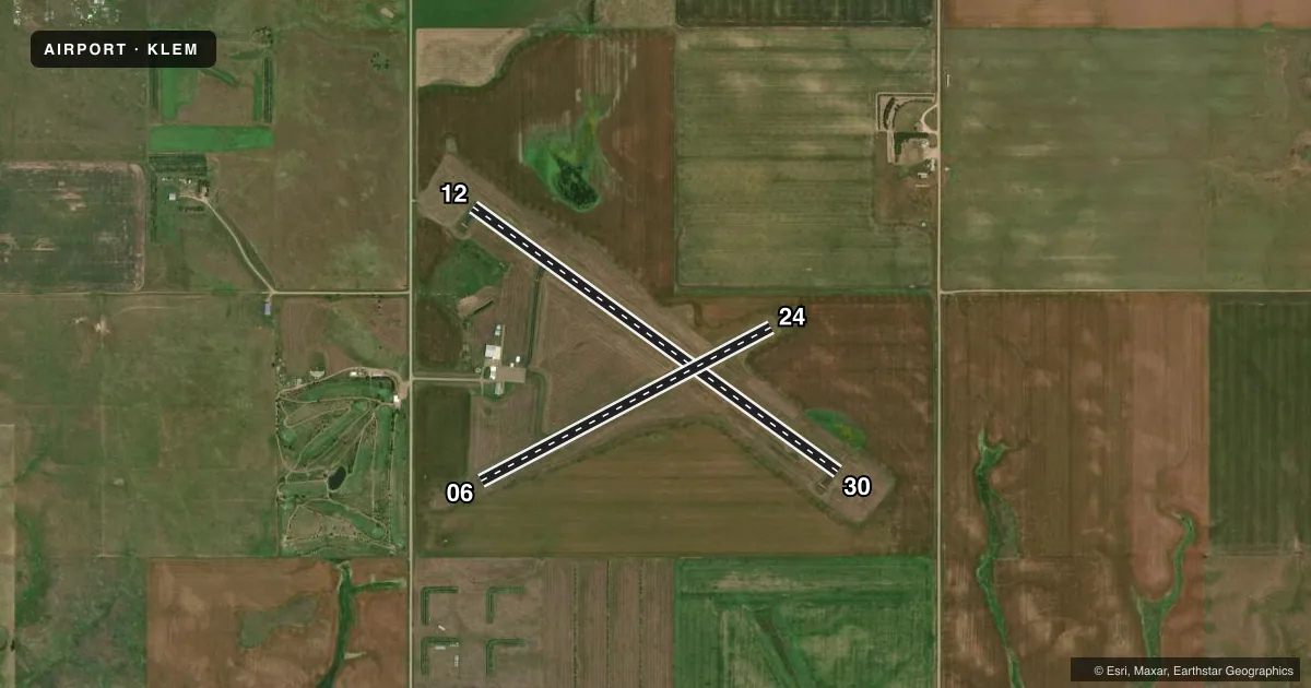
Airport sketch
Runways drawn to scale from FAA survey coordinates, rendered over satellite imagery. Not for navigation.
Approaches & charts
Services on the field
Fuel grades, oxygen, maintenance, ramp storage and lighting — as declared to the FAA by the airport operator.
Fuel & services
- Fuel
- 100LLA
- Oxygen (bottled)
- Not available
- Oxygen (bulk)
- Not available
- Airframe repair
- Minor
- Power plant repair
- Minor
- Other services
- AGRI,INSTR,RNTL
Ramp & ground
- Transient storage
- Tie-down
- Hangar
- Landing fee
- No fee published
- Customs
- Not available
- Lighting schedule
- SEE RMK
- Beacon schedule
- SS-SR
- Beacon
- White / Green (civil land)(WG)
- Wind indicator
- Lighted
- Segmented circle
- No
Fuel & FBOs
Cheapest 100LL and Jet A on the field and nearby. Always confirm with the FBO before taxi.
Airport notes
Surface conditions, obstructions, local procedures, lighting outages and other notes published with each FAA cycle.
General notes
- WILDLIFE ON AND INVOF ARPT.
- FOR CD CTC MINNEAPOLIS ARTCC AT 651-463-5588.
Lighting notes
- ACTVT PAPI RWY 12 & 30; MIRL RWY 12/30 - CTAF.
Fuel notes
- 100LLFUEL AVBL 24 HOURS WITH CREDIT CARD.
- AFUEL AVBL 24 HOURS WITH CREDIT CARD.
Approach & departure obstructions
- 06RWY 06/24 MKD WITH BLACK AND WHITE MKR CONES.
Other notes
- AUTOMATED UNICOM.
VFR map & nearby airports
VFR sectional. Tap any ICAO chip to open that airport.
Key facts · KLEM
Answer card- ICAO
- KLEM
- Name
- LEMMON MUNI
- Location
- LEMMON, SOUTH DAKOTA
- Elevation
- 2,572.8 ft MSL
- Traffic pattern altitude
- 3,572.8 ft MSL (1,000 AGL)
- Control tower
- Non-towered (use CTAF)
- Total runways
- 2
- Longest runway
- 12/30 · 4,499 ft
- Published ILS approaches
- 0
- Published frequencies
- 2
- Magnetic variation
- 6°
- Current flight rules
- VFR
- Current wind
- 110° at 10 kt
- Favored runway now
- RWY 12
Lemmon Muni sits in Lemmon, South Dakota. Field elevation is 2,572.8 ft MSL. The airport has two runways. The longest is runway 12/30 at 4,499 ft. Runway 06/24 is turf at 3,277 ft. This is an untowered field. CTAF and UNICOM are both 122.8. No ILS approaches are published here.
For pattern work, the published pattern altitude is not listed. Use the standard 1,000 ft AGL pattern unless the current Chart Supplement says otherwise. That puts the light piston pattern at about 3,573 ft MSL based on field elevation. Check the current Chart Supplement before you go if you want the latest published traffic pattern guidance.
Lemmon Air is on the field. It carries 100LL and Jet A Prist. Fuel is available 24 hours with credit card. PAPI is available for runways 12 and 30. Medium intensity runway lights are on 12 and 30. They are controlled by CTAF. Runways 06 and 24 are marked with black and white marker cones. Wildlife is present on and near the airport. Keep a sharp scan on taxi, takeoff and landing. For clearance delivery, contact Minneapolis ARTCC at 651-463-5588. If you need current operational details, call the airport operator or the FBO directly by phone.