METAR & TAF KBWW
Current METAR
Observed 09:15Z
KBWW 270915Z AUTO 11007KT 10SM FEW037 FEW044 21/08 A2996 RMK AO2
- Wind
- 110° @ 7 kt
- Visibility
- 10 SM
- Temp / Dew
- 21°C / 8°C
- Altimeter
- 29.96 inHg
- Clouds
- FEW
- Density alt
- 4,347 ft
- Ceiling
- Unlimited
- Rules
- VFR
Airport info & contacts
Manager on record, flight service, ARTCC, attendance schedule and pattern altitude — published by the FAA and refreshed every 28 days.
Location
- From city
- 4 NM E
- VFR sectional
- BILLINGS
- ARTCC
- ZLC · SALT LAKE CITY
- NOTAM facility
- GFK (NOTAM-D)
Airport manager
- Name
- BRENT KLINE
- Phone
- 701-523-7484
- Address
- PO BOX 331, BOWMAN ND 58623
Flight service · Hours
- FSS GFK
- GRAND FORKS1-800-WX-BRIEF
- Attendance
- MON-FRI · 0800-1700
Frequencies
Tap any row to copy the frequency to your clipboard.
Runways & pattern
Full pagePattern entry · RWY 13
LEFT TRAFFICRunway end performance
| End | TORA | TODA | ASDA | LDA | VGSI | Approach lights | Obstruction |
|---|---|---|---|---|---|---|---|
| 13 | — | — | — | — | PAPI 4-box left(3°) | — | — |
| 31 | — | — | — | — | PAPI 4-box left(3°) | — | — |
Declared distances in feet. TORA = takeoff run available, TODA = takeoff distance, ASDA = accelerate-stop, LDA = landing distance.
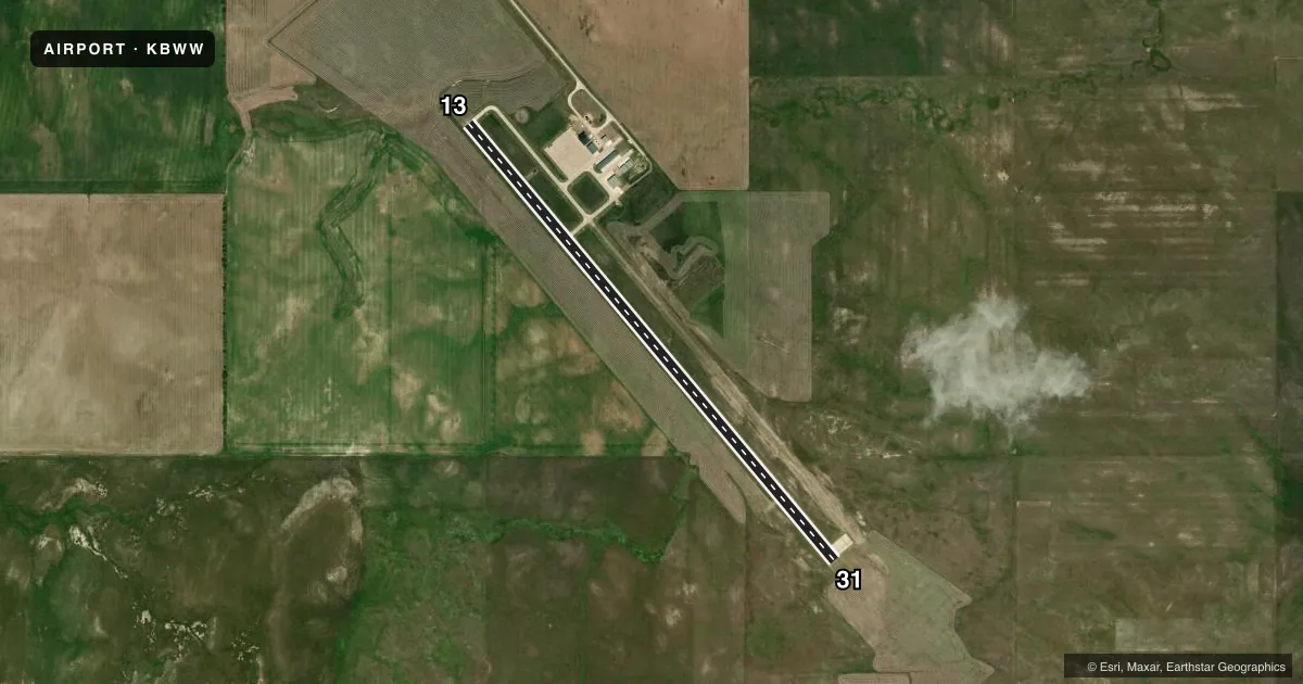
Airport sketch
Runways drawn to scale from FAA survey coordinates, rendered over satellite imagery. Not for navigation.
Approaches & charts
Services on the field
Fuel grades, oxygen, maintenance, ramp storage and lighting — as declared to the FAA by the airport operator.
Fuel & services
- Fuel
- 100LLA
- Oxygen (bottled)
- HIGH/LOW
- Oxygen (bulk)
- HIGH/LOW
- Airframe repair
- Major
- Power plant repair
- Major
- Other services
- AGRI,INSTR
Ramp & ground
- Transient storage
- Tie-down
- Hangar
- Lighting schedule
- SEE RMK
- Beacon schedule
- SS-SR
- Beacon
- White / Green (civil land)(WG)
- Wind indicator
- Lighted
- Segmented circle
- Yes
Fuel & FBOs
Cheapest 100LL and Jet A on the field and nearby. Always confirm with the FBO before taxi.
Airport notes
Surface conditions, obstructions, local procedures, lighting outages and other notes published with each FAA cycle.
General notes
- BIRDS & DEER ON & INVOF ARPT.
- CONFIRM SNOW REMOVAL WITH MGR AFT MAJOR STORM.
- FOR CD CTC SALT LAKE ARTCC AT 801-320-2568.
Lighting notes
- MIRL RWY 13/31; PAPI RWY 13 & 31 OPR SR-2200. MIRL RWY 13/31 PRESET LOW; AFT 2200 TO INCR INTST AND ACTVT REIL RWY 13/31; PAPI RWY 13 & 31; MIRL RWY 13/31 - CTAF.
Fuel notes
- 100LLSELF SVC FUEL AVBL H24 VIA CREDIT CARD.
Other notes
- 1FOR ATTENDANT & FUEL OTHER HRS CALL (701) 275-6352 OR (701) 440-0098.
- MANAGERAMGR CELL PHONE 701-440-7449.
VFR map & nearby airports
VFR sectional. Tap any ICAO chip to open that airport.
Key facts · KBWW
Answer card- ICAO
- KBWW
- Name
- BOWMAN RGNL
- Location
- BOWMAN, NORTH DAKOTA
- Elevation
- 2,965.4 ft MSL
- Traffic pattern altitude
- 3,965.4 ft MSL (1,000 AGL)
- Control tower
- Non-towered (use CTAF)
- Total runways
- 1
- Longest runway
- 13/31 · 5,701 ft
- Published ILS approaches
- 0
- Published frequencies
- 2
- Magnetic variation
- 7°
- Current flight rules
- VFR
- Current wind
- 110° at 7 kt
- Favored runway now
- RWY 13
Bowman Rgnl is in Bowman, North Dakota. Field elevation is 2,965.4 ft MSL. The airport has one runway. Runway 13/31 is 5,701 ft of concrete. There is no control tower. CTAF and UNICOM are both 122.8.
No ILS approaches are published here. Pattern altitude is not published, so use the standard 1,000 ft AGL for light piston traffic unless the current Chart Supplement says otherwise. The field sits in open country, so watch for birds and deer in the airport area. After a major storm, confirm snow removal with the manager before you launch or arrive.
Runway lighting is available on 13/31. The PAPI on both ends operates from sunset to 2200. After 2200, the runway lights increase in intensity and runway end identifier lights come on. Self-serve 100LL is available 24 hours a day by credit card. There are no on-field FBOs listed, so call the airport operator or the field directly for current fuel or attendant support outside normal hours. For clearance delivery, contact Salt Lake ARTCC. If you are planning IFR or night operations, verify the current Chart Supplement before departure.