METAR & TAF KDIK
Current METAR
Observed 15:56Z
KDIK 271556Z AUTO 09011KT 10SM CLR 30/07 A2993 RMK AO2 SLP110 T03000072
- Wind
- 090° @ 11 kt
- Visibility
- 10 SM
- Temp / Dew
- 30°C / 7°C
- Altimeter
- 29.93 inHg
- Clouds
- CLR
- Density alt
- 5,002 ft
- Ceiling
- Unlimited
- Rules
- VFR
Airport info & contacts
Manager on record, flight service, ARTCC, attendance schedule and pattern altitude — published by the FAA and refreshed every 28 days.
Location
- From city
- 5 NM S
- VFR sectional
- BILLINGS
- Pattern altitude
- 1,010 ft AGL · 3,602 ft MSL
- ARTCC
- ZMP · MINNEAPOLIS
- NOTAM facility
- DIK (NOTAM-D)
Airport manager
- Name
- KELLY BRAUN
- Phone
- 701-483-1062
- Address
- 11120 42ND ST SW, DICKINSON ND 58601-9282
Flight service · Hours
- FSS GFK
- GRAND FORKS1-800-WX-BRIEF
- Attendance
- 0700-1600
Frequencies
Tap any row to copy the frequency to your clipboard.
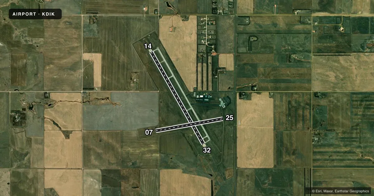
Runways & pattern
Full pagePattern entry · RWY 07
LEFT TRAFFIC| Runway | Heading (°M) | Length | Surface | Traffic |
|---|---|---|---|---|
| 14/32 | 140° / 320° | 7,301 ft | CONC | Standard L |
| 07/25Favored | 70° / 250° | 4,700 ft | ASPH | Standard L |
Runway end performance
| End | TORA | TODA | ASDA | LDA | VGSI | Approach lights | Obstruction |
|---|---|---|---|---|---|---|---|
| 14 | 7,301' | 7,301' | 7,301' | 7,301' | PAPI 4-box left(3°) | — | 65', pole, 2686' from thr, 676' R of cntrln, slope 38 |
| 32 | 7,301' | 7,301' | 7,301' | 7,301' | PAPI 4-box left(3°) | MALSR | 37', road, 2344' from thr, 666' R of cntrln, slope 50 |
| 07 | 4,700' | 4,700' | 4,700' | 4,700' | PAPI 4-box left(3°) | — | — |
| 25 | 4,700' | 4,700' | 4,700' | 4,700' | PAPI 4-box left(3°) | — | 28', road, 790' from thr, 300' R of cntrln, slope 21 |
Declared distances in feet. TORA = takeoff run available, TODA = takeoff distance, ASDA = accelerate-stop, LDA = landing distance.
Airport sketch
Runways drawn to scale from FAA survey coordinates, rendered over satellite imagery. Not for navigation.
Approaches & charts
ILS · 1
Services on the field
Fuel grades, oxygen, maintenance, ramp storage and lighting — as declared to the FAA by the airport operator.
Fuel & services
- Fuel
- 100LLA
- Oxygen (bottled)
- Not available
- Oxygen (bulk)
- Not available
- Airframe repair
- Major
- Power plant repair
- Major
- Other services
- AGRI,AMB,CHTR,INSTR,RNTL,SALES,SURV
Ramp & ground
- Transient storage
- Tie-down
- Hangar
- Landing fee
- No fee published
- Customs
- Not available
- Lighting schedule
- SEE RMK
- Beacon schedule
- SS-SR
- Beacon
- White / Green (civil land)(WG)
- Wind indicator
- Lighted
- Segmented circle
- Yes
Fuel & FBOs
Cheapest 100LL and Jet A on the field and nearby. Always confirm with the FBO before taxi.
Airport notes
Surface conditions, obstructions, local procedures, lighting outages and other notes published with each FAA cycle.
General notes
- CONC APRON FOR HEAVY ACFT PARKING.
- HAYING OPNS ADJ TO ALL SFCS JUN - SEP.
- CROP DUSTING OPNS INVOF ARPT.
- PAEW ON MOVEMENT AREAS DURG WINTER (OCT-APR).
- AIRFIELD SFC CONDS UNMON BTN 2300-0430.
- FOR CD IF UNA TO CTC ON FSS FREQ, CTC MINNEAPOLIS ARTCC AT 651-463-5588.
Lighting notes
- ACTVT MALSR RWY 32; REIL RWY 14, 07 & 25; PAPI RWY 14 & 32; HIRL RWY 14/32 - CTAF. PAPI RWY 07 & 25 OPR CONSLY SS-SR. MIRL RWY 07/25 PRESET ON LOW INTST DUSK-2200; TO INCR INTST AFT 2200 - CTAF.
Runway surface & condition
- 07/25PCR VALUE: 60/F/D/X/T
- 14/32PCR VALUE: 440/R/D/W/T
- 07/25RWY 07/25 NOT AVBL FOR PART 121/PART 380 OPS WITH SKED PAX CARRYING OPS MORE THAN 9 PAX SEATS AND NON-SKED PAX CARRYING OPS MORE THAN 30 PAX SEATS.
Other notes
- TPA SNGL ENG 1010 FT AGL; MULT ENG 1510 FT AGL.
- 1FOR SVC AFT HRS CALL 701-264-9966.
VFR map & nearby airports
VFR sectional. Tap any ICAO chip to open that airport.
Key facts · KDIK
Answer card- ICAO
- KDIK
- Name
- DICKINSON/THEODORE ROOSEVELT RGNL
- Location
- DICKINSON, NORTH DAKOTA
- Elevation
- 2,592.1 ft MSL
- Traffic pattern altitude
- 3,602.1 ft MSL (1,010 AGL)
- Control tower
- Non-towered (use CTAF)
- Total runways
- 2
- Longest runway
- 14/32 · 7,301 ft
- Published ILS approaches
- 1
- Published frequencies
- 2
- Magnetic variation
- 10°
- Current flight rules
- VFR
- Current wind
- 090° at 11 kt
- Favored runway now
- RWY 07
Dickinson/Theodore Roosevelt Rgnl sits in Dickinson, North Dakota. Field elevation is 2,592.1 ft MSL. The airport has two runways. The longest is 14/32 at 7,301 ft. There is no control tower. CTAF and UNICOM are both 123.0. An ILS is available to runway 32. Pattern altitude is 3,602.1 ft MSL for single-engine aircraft. Multi-engine aircraft use 4,102.1 ft MSL.
Western Edge Aviation is on the field. It carries 100LL, Jet A and Jet A Prist. The airport has a concrete apron for heavy aircraft parking. Runway 07/25 is not available for Part 121 or Part 380 scheduled passenger operations with more than 9 seats. It is also not available for non-scheduled passenger operations with more than 30 seats. That matters if you are planning a larger aircraft arrival.
This is a field where surface and seasonal activity deserve attention. Haying operations are adjacent to all surfaces from June through September. Crop dusting operations are also in the vicinity. Airfield surface conditions are unmonitored between 2300 and 0430. Winter plowing and sanding run from October through April. Runway 32 has MALSR lighting. Runway 14 and 32 have high intensity runway lights controlled by CTAF. If you need clearance delivery and cannot reach Flight Service, Minneapolis ARTCC is the published backup contact.