METAR & TAF 3P3
3P3 does not publish a METAR.
Showing the nearest reporting station: KHEI (HETTINGER/JB LINDQUIST RGNL) · 24.8 NM away. Conditions at 3P3 may differ.
METAR · KHEI
Observed 16:53Z
KHEI 271653Z AUTO 11011G17KT 10SM CLR 33/10 A2995 RMK AO2 SLP116 T03280100
- Wind
- 110° @ 11G17 kt
- Visibility
- 10 SM
- Temp / Dew
- 33°C / 10°C
- Altimeter
- 29.95 inHg
- Clouds
- CLR
- Density alt
- 5,116 ft
- Ceiling
- Unlimited
- Rules
- VFR
Airport info & contacts
Manager on record, flight service, ARTCC, attendance schedule and pattern altitude — published by the FAA and refreshed every 28 days.
Location
- From city
- 1 NM S
- VFR sectional
- BILLINGS
- ARTCC
- ZMP · MINNEAPOLIS
- NOTAM facility
- GFK (NOTAM-D)
Airport manager
- Name
- DEREK MAYER
- Phone
- 701-824-2030
- Address
- 406 MEADOW LANE, MOTT ND 58646
Flight service · Hours
- FSS GFK
- GRAND FORKS1-800-WX-BRIEF
- Attendance
- Unattended
Frequencies
Tap any row to copy the frequency to your clipboard.
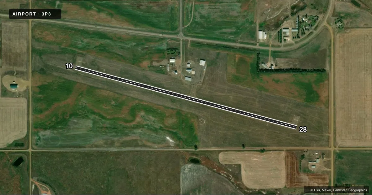
Runways & pattern
Full pagePattern entry · RWY 10
LEFT TRAFFICRunway end performance
| End | TORA | TODA | ASDA | LDA | VGSI | Approach lights | Obstruction |
|---|---|---|---|---|---|---|---|
| 10 | — | — | — | — | PAPI 2-box left(3°) | — | — |
| 28 | — | — | — | — | PAPI 2-box left(3°) | — | — |
Declared distances in feet. TORA = takeoff run available, TODA = takeoff distance, ASDA = accelerate-stop, LDA = landing distance.
Airport sketch
Runways drawn to scale from FAA survey coordinates, rendered over satellite imagery. Not for navigation.
Approaches & charts
Services on the field
Fuel grades, oxygen, maintenance, ramp storage and lighting — as declared to the FAA by the airport operator.
Fuel & services
- Fuel
- 100LL
- Oxygen (bottled)
- Not available
- Oxygen (bulk)
- Not available
- Airframe repair
- Not available
- Power plant repair
- Not available
- Other services
- AGRI
Ramp & ground
- Transient storage
- Tie-down
- Hangar
- Landing fee
- No fee published
- Customs
- Not available
- Lighting schedule
- SEE RMK
- Beacon schedule
- SS-SR
- Beacon
- White / Green (civil land)(WG)
- Wind indicator
- Lighted
- Segmented circle
- Yes
Fuel & FBOs
Cheapest 100LL and Jet A on the field and nearby. Always confirm with the FBO before taxi.
Airport notes
Surface conditions, obstructions, local procedures, lighting outages and other notes published with each FAA cycle.
General notes
- +100 FT TWR - L ON FARMSTEAD 1800 FT R OF RWY 28 THR.
- VFY WINTER CONDS CALL 701-260-2535 OR 701-824-2163.
- DEER ON & INVOF ARPT.
- FOR CD CTC MINNEAPOLIS ARTCC AT 651-463-5588.
Lighting notes
- ACTVT PAPI RWY 10 & 28; MIRL RWY 10/28 - CTAF.
Fuel notes
- 100LLSELF SVC FUEL AVBL H24 VIA CREDIT CARD.
Other notes
- MANAGERADDL CTC DEREK MAYER 701-260-3525.
- OWNEROWEN BLICKENSDERFER CHRMN APT AUTH 701-567-3861.
VFR map & nearby airports
VFR sectional. Tap any ICAO chip to open that airport.
Key facts · 3P3
Answer card- ICAO
- 3P3
- Name
- MOTT MUNI
- Location
- MOTT, NORTH DAKOTA
- Elevation
- 2,413.9 ft MSL
- Traffic pattern altitude
- 3,413.9 ft MSL (1,000 AGL)
- Control tower
- Non-towered (use CTAF)
- Total runways
- 1
- Longest runway
- 10/28 · 4,001 ft
- Published ILS approaches
- 0
- Published frequencies
- 1
- Magnetic variation
- 7°
- Current flight rules
- VFR
- Current wind
- 110° at 11 kt
- Favored runway now
- RWY 10
Mott Muni sits in Mott, North Dakota. The field elevation is 2,413.9 ft MSL. It has one runway, 10/28, which is 4,001 ft long. There is no control tower. CTAF is 122.9. No ILS approaches are published here.
The published pattern altitude is not listed, so use the standard 1,000 ft AGL for light piston operations unless the current FAA Chart Supplement says otherwise. Self-serve 100LL is available 24 hours a day by credit card. The airport remarks also note medium intensity runway lights on 10 and 28 plus PAPI on both ends. That makes night work more straightforward, but you still need to confirm current field conditions before you go.
This is a non-towered field with some local hazards to keep in mind. A 100-foot tower sits on a farmstead about 1,800 feet right of the runway 28 threshold. Deer are reported on and near the airport. Winter conditions can change fast here, so call ahead if you need a runway condition check. For clearance delivery, contact Minneapolis ARTCC. If you need airport-specific help, the manager contact is listed in the Chart Supplement.