METAR & TAF D57
Current METAR
Observed 15:35Z
KD57 271535Z AUTO 07006KT 10SM CLR 26/14 A2990 RMK AO2
- Wind
- 070° @ 6 kt
- Visibility
- 10 SM
- Temp / Dew
- 26°C / 14°C
- Altimeter
- 29.90 inHg
- Clouds
- CLR
- Density alt
- 3,938 ft
- Ceiling
- Unlimited
- Rules
- VFR
Airport info & contacts
Manager on record, flight service, ARTCC, attendance schedule and pattern altitude — published by the FAA and refreshed every 28 days.
Location
- From city
- 2 NM W
- VFR sectional
- BILLINGS
- ARTCC
- ZMP · MINNEAPOLIS
- NOTAM facility
- GFK (NOTAM-D)
Airport manager
- Name
- GENE GLASSER
- Phone
- 701-226-1147
- Address
- P.O. BOX 306, GLEN ULLIN ND 58631
Flight service · Hours
- FSS GFK
- GRAND FORKS1-800-WX-BRIEF
- Attendance
- Unattended
Frequencies
Tap any row to copy the frequency to your clipboard.
Runways & pattern
Full pagePattern entry · RWY 11
LEFT TRAFFICRunway end performance
| End | TORA | TODA | ASDA | LDA | VGSI | Approach lights | Obstruction |
|---|---|---|---|---|---|---|---|
| 11 | — | — | — | — | PAPI 2-box left(3°) | — | — |
| 29 | — | — | — | — | PAPI 2-box left(3°) | — | — |
Declared distances in feet. TORA = takeoff run available, TODA = takeoff distance, ASDA = accelerate-stop, LDA = landing distance.
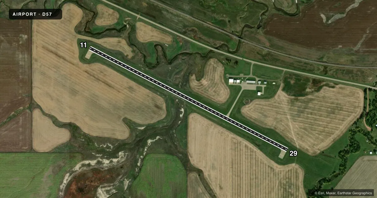
Airport sketch
Runways drawn to scale from FAA survey coordinates, rendered over satellite imagery. Not for navigation.
Approaches & charts
Services on the field
Fuel grades, oxygen, maintenance, ramp storage and lighting — as declared to the FAA by the airport operator.
Fuel & services
- Fuel
- 100LL
- Oxygen (bottled)
- Not available
- Oxygen (bulk)
- Not available
- Airframe repair
- Not available
- Power plant repair
- Not available
Ramp & ground
- Transient storage
- Tie-down
- Hangar
- Landing fee
- No fee published
- Customs
- Not available
- Lighting schedule
- SEE RMK
- Wind indicator
- Lighted
- Segmented circle
- Yes
Fuel & FBOs
Cheapest 100LL and Jet A on the field and nearby. Always confirm with the FBO before taxi.
Airport notes
Surface conditions, obstructions, local procedures, lighting outages and other notes published with each FAA cycle.
General notes
- TO CFM SNOW REMOVAL & WINTER COND CALL AMGR.
- FOR CD CTC MINNEAPOLIS ARTCC AT 651-463-5588.
Lighting notes
- ACTVT MIRL RWY 11/29; PAPI RWY 11 & 29 - CTAF.
Fuel notes
- 100LLSELF SVC H24 VIA CREDIT CARD.
Other notes
- OWNERAMGR.
VFR map & nearby airports
VFR sectional. Tap any ICAO chip to open that airport.
Key facts · D57
Answer card- ICAO
- D57
- Name
- GLEN ULLIN RGNL
- Location
- GLEN ULLIN, NORTH DAKOTA
- Elevation
- 2,091 ft MSL
- Traffic pattern altitude
- 3,091 ft MSL (1,000 AGL)
- Control tower
- Non-towered (use CTAF)
- Total runways
- 1
- Longest runway
- 11/29 · 3,799 ft
- Published ILS approaches
- 0
- Published frequencies
- 1
- Magnetic variation
- 7°
- Current flight rules
- VFR
- Current wind
- 070° at 6 kt
- Favored runway now
- RWY 11
Glen Ullin Rgnl (D57) sits in Glen Ullin, North Dakota. Field elevation is 2,091 ft MSL. The airport has one runway. Runway 11/29 is 3,799 ft of asphalt, so plan performance with the elevation in mind. There is no control tower. CTAF is 122.9.
No ILS approaches are published here. The pattern altitude is not published, so use the standard 1,000 ft AGL for light piston operations unless the current Chart Supplement says otherwise. Runway 11/29 has medium intensity lighting. PAPI is available on runways 11 and 29. It is activated via CTAF.
Glen Ullin Regional Airport is the on-field FBO. It carries AVGAS 100LL. Self-serve 100LL is available 24 hours by credit card. The airport manager should be your contact for snow removal and winter conditions. For clearance delivery, Minneapolis ARTCC is listed in the remarks. This is a small field with straightforward runway layout. The elevation and North Dakota winter weather can matter on takeoff and landing performance.