METAR & TAF 95D
95D does not publish a METAR.
Showing the nearest reporting station: KHZE (MERCER COUNTY RGNL) · 9.8 NM away. Conditions at 95D may differ.
METAR · KHZE
Observed 13:35Z
KHZE 271335Z AUTO 26003KT 9SM CLR 19/10 A2993 RMK AO2
- Wind
- 260° @ 3 kt
- Visibility
- 9 SM
- Temp / Dew
- 19°C / 10°C
- Altimeter
- 29.93 inHg
- Clouds
- CLR
- Density alt
- 2,688 ft
- Ceiling
- Unlimited
- Rules
- VFR
Airport info & contacts
Manager on record, flight service, ARTCC, attendance schedule and pattern altitude — published by the FAA and refreshed every 28 days.
Location
- From city
- 2 NM SW
- VFR sectional
- BILLINGS
- ARTCC
- ZMP · MINNEAPOLIS
- NOTAM facility
- GFK (NOTAM-D)
Airport manager
- Name
- SHAWN MORTEN
- Phone
- 701-873-4100
- Address
- 6220 COUNTY 20, BEULAH ND 58523
Flight service · Hours
- FSS GFK
- GRAND FORKS1-800-WX-BRIEF
- Attendance
- OCT-APR · MON-SAT · ON CALL
Frequencies
Tap any row to copy the frequency to your clipboard.
Runways & pattern
Full pagePattern entry · RWY 28
LEFT TRAFFICRunway end performance
| End | TORA | TODA | ASDA | LDA | VGSI | Approach lights | Obstruction |
|---|---|---|---|---|---|---|---|
| 10 | — | — | — | — | — | — | 4', fence, 200' from thr, 55' R of cntrln, slope 0 |
| 28 | — | — | — | — | S2L 2-box left(3°) | — | 10', road, 200' from thr, 0' R of cntrln, slope 0 |
Declared distances in feet. TORA = takeoff run available, TODA = takeoff distance, ASDA = accelerate-stop, LDA = landing distance.
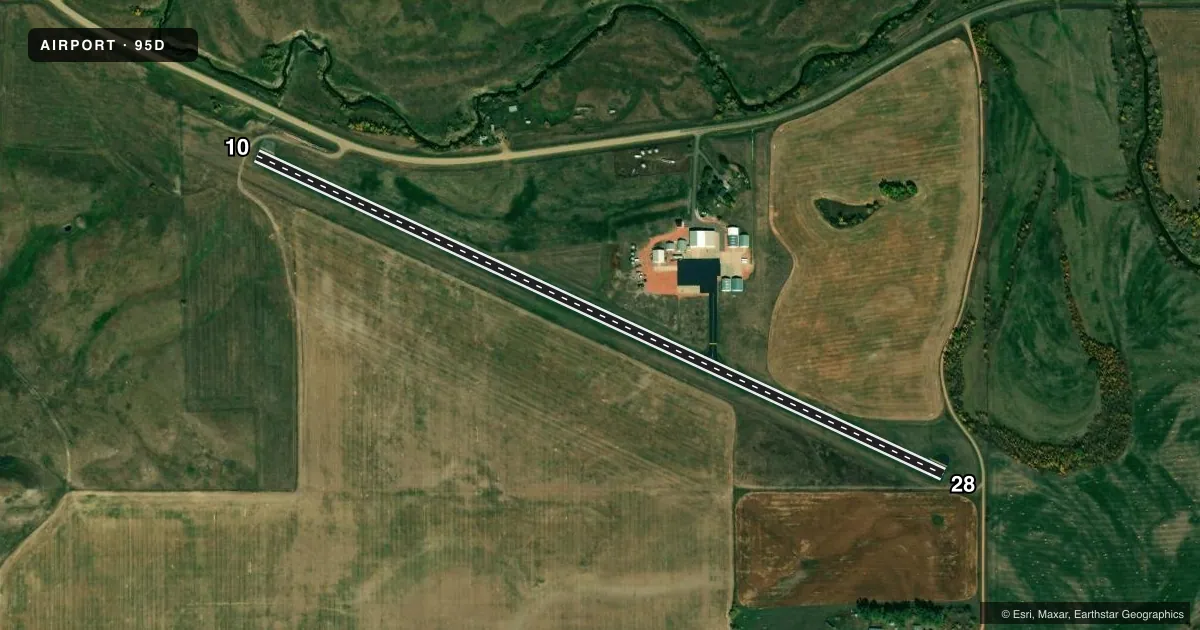
Airport sketch
Runways drawn to scale from FAA survey coordinates, rendered over satellite imagery. Not for navigation.
Approaches & charts
Services on the field
Fuel grades, oxygen, maintenance, ramp storage and lighting — as declared to the FAA by the airport operator.
Fuel & services
- Fuel
- 100LL
- Airframe repair
- Major
- Power plant repair
- Major
- Other services
- AGRI,INSTR,SALES,SURV
Ramp & ground
- Transient storage
- Tie-down
- Hangar
- Landing fee
- No fee published
- Customs
- Not available
- Lighting schedule
- SEE RMK
- Beacon schedule
- SEE RMK
- Beacon
- White / Green (civil land)(WG)
- Wind indicator
- Lighted
- Segmented circle
- No
Fuel & FBOs
Cheapest 100LL and Jet A on the field and nearby. Always confirm with the FBO before taxi.
Airport notes
Surface conditions, obstructions, local procedures, lighting outages and other notes published with each FAA cycle.
General notes
- LIGHTED STACK 498' AGL LCTD 1.8 NM S.
- ARPT LCTD IN RIVER VALLEY WITH +200' RDGS SRNDG APRX 1500' FM THR.
- 250 FT AGL STACK WITH INVISIBLE FLAME TO 250 FT ABV STACK LCTD 8 NM NNW.
- SNOW REMOVAL IREG; CONFIRM WINTER CONDITIONS WITH AMGR (701) 873-4100 OR (701) 870-4100.
- STACKS 600 FT AGL 6 MI N UNLGTD.
- BIRDS & DEER ON & INVOF ARPT.
- FOR CD CTC MINNEAPOLIS ARTCC AT 651-463-5588.
Lighting notes
- ACTVT ROTG BCN - CTAF.
- ACTVT LIRL RY 10/28 & SAVASI RY 28 - CTAF.
Fuel notes
- 100LLFOR FUEL CALL 701-873-4100/2259/2311.
Runway surface & condition
- 10/28NSTD LIRL 20 FT FROM EDGE OF ASPH SFC.
Approach & departure obstructions
- 10+4 FT FENCE 115 FT FM THLD 60 FT L OF CNTRLN. +15 FT TREE 115 FT FM THLD 60 FT L OF CNTRLN.
- 28+4 FT FENCE 100 FT FM THLD 50 FT LEFT OF CNTRLN.
- 10CLTG OBSTN EXCEEDS A 45 DEG SLP.
- 10ROAD 10 FT ABV RWY HGT PENETRATES APCH.
Other notes
- PRVDD RWY 10 THR IS DSPLCD TO PRVD A MIN 20:1 OBSTN FREE CLNC OVER A 15' VEHICLE ON COUNTY ROAD.
- 2AMGR ON CALL CONSLY (710) 873-4100.
- OWNERCHAIR OF APT AUTH - BO KLINDWORTH
- MANAGEROR CTC KEVIN LEE, ARPT AUTH (701) 873-2259 OR (701) 873-2311.
VFR map & nearby airports
VFR sectional. Tap any ICAO chip to open that airport.
Key facts · 95D
Answer card- ICAO
- 95D
- Name
- BEULAH
- Location
- BEULAH, NORTH DAKOTA
- Elevation
- 1,791 ft MSL
- Traffic pattern altitude
- 2,791 ft MSL (1,000 AGL)
- Control tower
- Non-towered (use CTAF)
- Total runways
- 1
- Longest runway
- 10/28 · 4,030 ft
- Published ILS approaches
- 0
- Published frequencies
- 1
- Magnetic variation
- 11°
- Current flight rules
- VFR
- Current wind
- 260° at 3 kt
- Favored runway now
- RWY 28
BEULAH (95D) sits in Beulah, North Dakota. Field elevation is 1,791 ft MSL. The airport has one runway, 10/28, which is 4,030 ft long and paved with asphalt. There is no control tower. CTAF is 122.9. No ILS approaches are published here.
Pattern altitude is not published. Use the standard 1,000 ft AGL pattern unless the current Chart Supplement says otherwise. Dakota Helicopters is on the field. It carries 100LL. Call (701) 873-4100 for fuel and current service details.
This is a valley airport with ridges more than 200 ft high around the field about 1,500 ft from the threshold. That matters on arrival and departure. The published remarks also note a road that rises above runway level and penetrates the approach. Runway 10 has a displaced threshold for obstacle clearance. There are fences and a tree near the approach end of both runway directions. Low intensity runway lights, the rotating beacon and the visual glide aid on runway 28 are activated on CTAF. For clearance delivery, contact Minneapolis ARTCC. If you need the airport manager, the published numbers are available in the Chart Supplement.