METAR & TAF 5C8
5C8 does not publish a METAR.
Showing the nearest reporting station: KHZE (MERCER COUNTY RGNL) · 22.9 NM away. Conditions at 5C8 may differ.
METAR · KHZE
Observed 15:35Z
KHZE 241535Z AUTO 33012KT 10SM SCT020 BKN027 17/09 A3017 RMK AO2
- Wind
- 330° @ 12 kt
- Visibility
- 10 SM
- Temp / Dew
- 17°C / 9°C
- Altimeter
- 30.17 inHg
- Clouds
- BKN
- Density alt
- 2,296 ft
- Ceiling
- 2,700 ft AGL
- Rules
- MVFR
Airport info & contacts
Manager on record, flight service, ARTCC, attendance schedule and pattern altitude — published by the FAA and refreshed every 28 days.
Location
- From city
- 4 NM N
- VFR sectional
- BILLINGS
- ARTCC
- ZMP · MINNEAPOLIS
- NOTAM facility
- GFK (NOTAM-D)
Airport manager
- Name
- DON ROBINSON
- Phone
- 701-460-0196
- Address
- BOX 403, WASHBURN ND 58577
Flight service · Hours
- FSS GFK
- GRAND FORKS1-800-WX-BRIEF
- Attendance
- Unattended
Frequencies
Tap any row to copy the frequency to your clipboard.
Runways & pattern
Full pagePattern entry · RWY 35
LEFT TRAFFIC| Runway | Heading (°M) | Length | Surface | Traffic |
|---|---|---|---|---|
| 08/26 | 80° / 260° | 3,700 ft | CONC | Standard L |
| 17/35Favored | 170° / 350° | 2,204 ft | TURF | Standard L |
Runway end performance
| End | TORA | TODA | ASDA | LDA | VGSI | Approach lights | Obstruction |
|---|---|---|---|---|---|---|---|
| 08 | — | — | — | — | PAPI 2-box left(3°) | — | — |
| 26 | — | — | — | — | PAPI 2-box left(3°) | — | — |
Declared distances in feet. TORA = takeoff run available, TODA = takeoff distance, ASDA = accelerate-stop, LDA = landing distance.
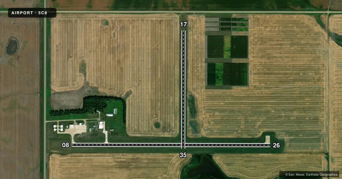
Airport sketch
Runways drawn to scale from FAA survey coordinates, rendered over satellite imagery. Not for navigation.
Approaches & charts
Services on the field
Fuel grades, oxygen, maintenance, ramp storage and lighting — as declared to the FAA by the airport operator.
Fuel & services
- Fuel
- 100LL
- Oxygen (bottled)
- Not available
- Oxygen (bulk)
- Not available
- Airframe repair
- Not available
- Power plant repair
- Not available
- Other services
- AGRI
Ramp & ground
- Transient storage
- Tie-down
- Landing fee
- No fee published
- Customs
- Not available
- Lighting schedule
- SEE RMK
- Beacon schedule
- SS-SR
- Beacon
- White / Green (civil land)(WG)
- Wind indicator
- Lighted
- Segmented circle
- Yes
Fuel & FBOs
Cheapest 100LL and Jet A on the field and nearby. Always confirm with the FBO before taxi.
Airport notes
Surface conditions, obstructions, local procedures, lighting outages and other notes published with each FAA cycle.
General notes
- +700' SMOKE STACK OF POWER PLANT LOCATED 6 MI WNW OF ARPT.
- WATERFOWL, BLACKBIRDS, DEER, & ANTELOPE ON AND INVOF OF ARPT.
- CONFIRM WINTER CONDITIONS WITH ARPT MGR AFTER MAJOR STORM PRIOR TO USE - SNOW REMOVAL IRREGULAR SCHEDULE.
- FOR CD CTC MINNEAPOLIS ARTCC AT 651-463-5588.
Lighting notes
- ACTVT MIRL RY 08/26 & PAPI RY 8/26 - CTAF. LOW INTST NOT AVBL.
Fuel notes
- 100LL24HR SELF-SERVICE FUEL AVBL WITH CREDIT CARD.
Runway surface & condition
- 17/35CLSD WINTER MONTHS DUE TO LACK OF SNOW REMOVAL.
Approach & departure obstructions
- 17MKD WITH DALGT BOUNDARY MARKERS; BLACK/WHITE CONES.
- 35MKD WITH DALGT BOUNDARY MARKERS; BLACK/WHITE CONES.
- 35+150 FT EAST-WEST TRANSMISSION LINE 9500' SOUTH ON EXTNDD CNTRLN.
Other notes
- EXISTED PRIOR TO 1959.
VFR map & nearby airports
VFR sectional. Tap any ICAO chip to open that airport.
Key facts · 5C8
Answer card- ICAO
- 5C8
- Name
- WASHBURN MUNI
- Location
- WASHBURN, NORTH DAKOTA
- Elevation
- 1,908 ft MSL
- Traffic pattern altitude
- 2,908 ft MSL (1,000 AGL)
- Control tower
- Non-towered (use CTAF)
- Total runways
- 2
- Longest runway
- 08/26 · 3,700 ft
- Published ILS approaches
- 0
- Published frequencies
- 1
- Magnetic variation
- 10°
- Current flight rules
- MVFR
- Current wind
- 330° at 12 kt
- Favored runway now
- RWY 35
Washburn Muni sits in Washburn, North Dakota. The field elevation is 1,908 ft MSL. It has two runways. The longest is 08/26 at 3,700 ft of concrete. The other runway is 17/35 at 2,204 ft of turf. Runway 17/35 is closed in winter because snow removal is not provided on a regular schedule.
This is an untowered field. CTAF is 122.9. No ILS approaches are published. Pattern altitude is not published, so use the standard 1,000 ft AGL for light piston traffic unless the current FAA Chart Supplement says otherwise. That puts the normal pattern reference at 2,908 ft MSL.
The airport has 24-hour self-serve 100LL with credit card. Medium intensity runway lights are available on 08/26. The PAPI for 08/26 is controlled by CTAF. Low intensity lighting is not available. For clearance delivery, Minneapolis ARTCC handles it by phone. Wildlife is part of the picture here. Waterfowl, blackbirds, deer and antelope have all been reported on or near the airport. A tall smoke stack sits about 6 miles west-northwest of the field. Plan for North Dakota weather and winter surface conditions. Check with the airport manager after a major storm before using the airport.
There are no on-field FBOs listed in the facts. Verify services directly before you go.