METAR & TAF 91N
91N does not publish a METAR.
Showing the nearest reporting station: KHZE (MERCER COUNTY RGNL) · 30.0 NM away. Conditions at 91N may differ.
METAR · KHZE
Observed 18:35Z
KHZE 271835Z AUTO 07005G11KT 10SM CLR 31/10 A2992 RMK AO2
- Wind
- 070° @ 5G11 kt
- Visibility
- 10 SM
- Temp / Dew
- 31°C / 10°C
- Altimeter
- 29.92 inHg
- Clouds
- CLR
- Density alt
- 4,296 ft
- Ceiling
- Unlimited
- Rules
- VFR
Airport info & contacts
Manager on record, flight service, ARTCC, attendance schedule and pattern altitude — published by the FAA and refreshed every 28 days.
Location
- From city
- 1 NM SW
- VFR sectional
- TWIN CITIES
- ARTCC
- ZMP · MINNEAPOLIS
- NOTAM facility
- GFK (NOTAM-D)
Airport manager
- Name
- JOE JOHNSON
- Phone
- (701) 516-3826
- Address
- 1679 13TH AVE NW, TURTLE LAKE ND 58575
Flight service · Hours
- FSS GFK
- GRAND FORKS1-800-WX-BRIEF
- Attendance
- Unattended
Frequencies
Tap any row to copy the frequency to your clipboard.
Runways & pattern
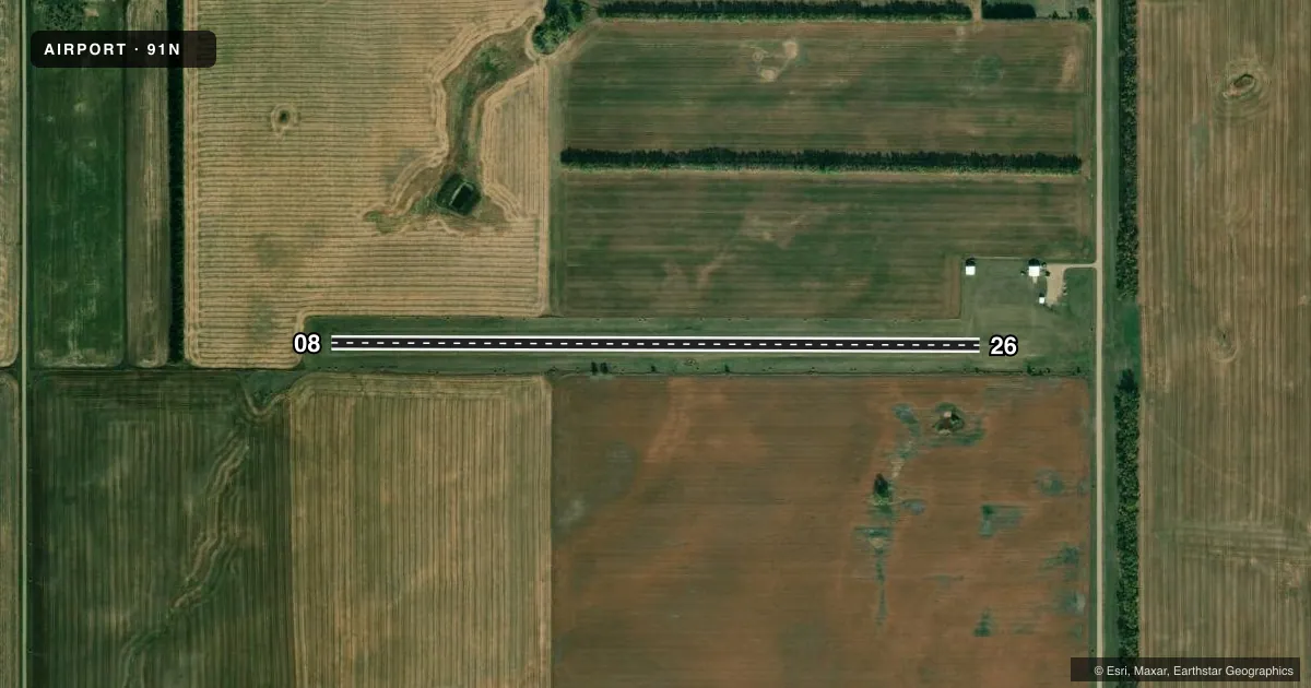
Full pagePattern entry · RWY 08
LEFT TRAFFICAirport sketch
Runways drawn to scale from FAA survey coordinates, rendered over satellite imagery. Not for navigation.
Approaches & charts
Services on the field
Fuel grades, oxygen, maintenance, ramp storage and lighting — as declared to the FAA by the airport operator.
Fuel & services
- Fuel
- Not available
- Other services
- AGRI
Ramp & ground
- Transient storage
- Tie-down
- Landing fee
- No fee published
- Lighting schedule
- SEE RMK
- Wind indicator
- Yes
- Segmented circle
- No
Fuel & FBOs
Cheapest 100LL and Jet A on the field and nearby. Always confirm with the FBO before taxi.
Airport notes
Surface conditions, obstructions, local procedures, lighting outages and other notes published with each FAA cycle.
General notes
- DEER AND WILDLIFE ON & INVOF ARPT.
- CONFIRM WINTER CONDITIONS WITH AMGR BEFORE USE DUE TO IREG SNOW REMOVAL. CALL (701) 220-0707.
- RY 08 HAS 10 FT DROPOFF 50 FT OUT FROM THR.
- FOR CD CTC MINNEAPOLIS ARTCC AT 651-463-5588.
Lighting notes
- ACTVT LIRL RY 08/26 - CTAF. LIRL RY 08/26 OUT OF SERVICE INDEFINITELY.
Runway surface & condition
- 08/26LIRL RY 08/26 OUT OF SERVICE INDEFINITELY.
Approach & departure obstructions
- 08RY 8 33 FT TREES 740 FT FROM THR ON CNTRLN; APCH RATIO 22:1.
- 26+17 FT ROAD 530 FT FROM THR ON CNTRLN, APCH RATIO 31:1.
Other notes
- PRVDD OBS FREE ZONE & APCH AREA ARE CLEAR; RY SLOPE & GRADING GRADIENTS ARE CHECKED FOR ACCEPTABILITY.
- OWNERADDL CTC ERIC JOHNSON ARPT AUTH (701) 391-3028 OR JON SEEGER (701) 220-0707.
- 08/26RY 08/26, GRASS SOFT SFC WHEN WET.
VFR map & nearby airports
VFR sectional. Tap any ICAO chip to open that airport.
Key facts · 91N
Answer card- ICAO
- 91N
- Name
- TURTLE LAKE MUNI
- Location
- TURTLE LAKE, NORTH DAKOTA
- Elevation
- 1,916 ft MSL
- Traffic pattern altitude
- 2,916 ft MSL (1,000 AGL)
- Control tower
- Non-towered (use CTAF)
- Total runways
- 1
- Longest runway
- 08/26 · 3,148 ft
- Published ILS approaches
- 0
- Published frequencies
- 2
- Magnetic variation
- 10°
- Current flight rules
- VFR
- Current wind
- 070° at 5 kt
- Favored runway now
- RWY 08
Turtle Lake Muni sits in Turtle Lake, North Dakota. Field elevation is 1,916 ft MSL. The airport has one runway. Runway 08/26 is 3,148 ft long with a turf surface. There is no control tower. CTAF and UNICOM are both 122.8. No ILS approaches are published here.
Pattern altitude is not published. Use the standard 1,000 ft AGL pattern for light piston aircraft unless the current FAA Chart Supplement or the airport operator says otherwise. The airport remarks matter here. Runway 08/26 is soft when wet. Low intensity runway lights on 08/26 are out of service indefinitely. Deer and wildlife are reported on and near the field. There is also a 10 ft dropoff 50 ft beyond the threshold on Runway 08. Obstacles are close enough to matter. Runway 08 has 33 ft trees 740 ft from the threshold on centerline. Runway 26 has a 17 ft road 530 ft from the threshold on centerline.
There are no on-field FBOs listed. Plan ahead for your own fuel and service needs. For winter use, confirm conditions with the airport manager before you go. If you need clearance delivery, the published contact is Minneapolis ARTCC. This is a small non-towered field with turf, wildlife and winter surface concerns. Treat it like a short-field planning airport.