METAR & TAF 9Y1
Current METAR
Observed 13:35Z
K9Y1 271335Z AUTO 00000KT 7SM HZ CLR 20/13 A2993 RMK AO2
- Wind
- 000° @ 0 kt
- Visibility
- 7 SM
- Temp / Dew
- 20°C / 13°C
- Altimeter
- 29.93 inHg
- Clouds
- CLR
- Density alt
- 3,376 ft
- Ceiling
- Unlimited
- Rules
- VFR
Airport info & contacts
Manager on record, flight service, ARTCC, attendance schedule and pattern altitude — published by the FAA and refreshed every 28 days.
Location
- From city
- 2 NM NW
- VFR sectional
- BILLINGS
- ARTCC
- ZMP · MINNEAPOLIS
- NOTAM facility
- GFK (NOTAM-D)
Airport manager
- Name
- GREG SYNNES
- Phone
- (701) 260-1235
- Address
- P.O. BOX 920
Flight service · Hours
- FSS PNM
- PRINCETON1-800-WX-BRIEF
- Attendance
- Unattended
Frequencies
Tap any row to copy the frequency to your clipboard.
Runways & pattern
Full pagePattern entry · RWY 13
LEFT TRAFFICRunway end performance
| End | TORA | TODA | ASDA | LDA | VGSI | Approach lights | Obstruction |
|---|---|---|---|---|---|---|---|
| 13 | — | — | — | — | PAPI 2-box left(3°) | — | — |
| 31 | — | — | — | — | PAPI 2-box left(3°) | — | — |
Declared distances in feet. TORA = takeoff run available, TODA = takeoff distance, ASDA = accelerate-stop, LDA = landing distance.
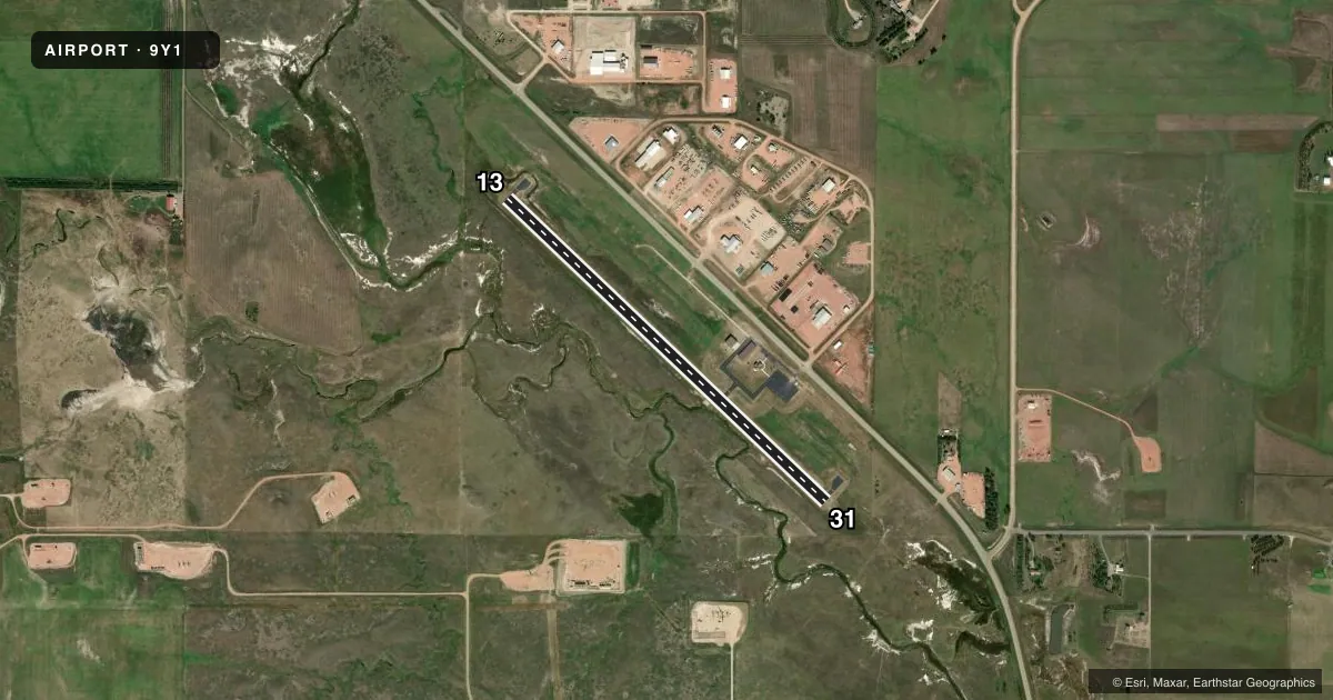
Airport sketch
Runways drawn to scale from FAA survey coordinates, rendered over satellite imagery. Not for navigation.
Approaches & charts
Services on the field
Fuel grades, oxygen, maintenance, ramp storage and lighting — as declared to the FAA by the airport operator.
Fuel & services
- Fuel
- 100LLA+
- Oxygen (bottled)
- Not available
- Oxygen (bulk)
- Not available
- Airframe repair
- Not available
- Power plant repair
- Not available
Ramp & ground
- Transient storage
- Tie-down
- Hangar
- Landing fee
- No fee published
- Lighting schedule
- SEE RMK
- Wind indicator
- Lighted
- Segmented circle
- No
Fuel & FBOs
Cheapest 100LL and Jet A on the field and nearby. Always confirm with the FBO before taxi.
Airport notes
Surface conditions, obstructions, local procedures, lighting outages and other notes published with each FAA cycle.
General notes
- +500' KILLDEER MTNS 5 MI NW OF ARPT.
- TO CONFIRM SNOW REMOVAL PHONE CTC AMGR 701-260-1235 OR 701-290-4925.
- FOR CD CTC MINNEAPOLIS ARTCC AT 651-463-5588.
- DEER & BIRDS ON & INVOF APRT.
Lighting notes
- ACTVT PAPI RWY 13 & 31; MIRL RWY 13/31 - CTAF.
Fuel notes
- 100LLSELF SVC FUEL AVBLE H24 VIA CREDIT CARD OR CALL AMGR 701-260-1235.
VFR map & nearby airports
VFR sectional. Tap any ICAO chip to open that airport.
Key facts · 9Y1
Answer card- ICAO
- 9Y1
- Name
- DUNN COUNTY WEYDAHL FLD
- Location
- KILLDEER, NORTH DAKOTA
- Elevation
- 2,249 ft MSL
- Traffic pattern altitude
- 3,249 ft MSL (1,000 AGL)
- Control tower
- Non-towered (use CTAF)
- Total runways
- 1
- Longest runway
- 13/31 · 4,200 ft
- Published ILS approaches
- 0
- Published frequencies
- 1
- Magnetic variation
- 7°
- Current flight rules
- VFR
- Current wind
- 000° at 0 kt
- Favored runway now
- –
Dunn County Weydahl Fld (9Y1) is in Killdeer, North Dakota. The field elevation is 2,249 ft MSL. It has one runway. Runway 13/31 is 4,200 ft of asphalt, which is the longest runway on the field. The airport is not towered. CTAF is 122.9.
No ILS approaches are published here. Pattern altitude is not published, so use the current Chart Supplement and local procedures before you arrive. The published remarks say 100LL self-serve is available 24 hours a day with credit card access. If you need confirmation on snow removal, call the airport manager before departure. The remarks also note deer and birds on and near the airport. That matters here.
PAPI is available on both runway ends. Medium intensity runway lights are on runways 13 and 31. They are controlled by CTAF. The airport sits in western North Dakota with the Killdeer Mountains about 5 miles northwest. That means terrain awareness matters on arrival and departure. For clearances, contact Minneapolis ARTCC. There are no on-field FBOs listed, so verify services with the airport operator or the airport manager before you go.