METAR & TAF S25
Current METAR
Observed 13:35Z
KS25 271335Z AUTO 07004KT 10SM 19/13 A2992 RMK AO2
- Wind
- 070° @ 4 kt
- Visibility
- 10 SM
- Temp / Dew
- 19°C / 13°C
- Altimeter
- 29.92 inHg
- Clouds
- Clear
- Density alt
- 3,128 ft
- Ceiling
- Unlimited
- Rules
- VFR
Airport info & contacts
Manager on record, flight service, ARTCC, attendance schedule and pattern altitude — published by the FAA and refreshed every 28 days.
Location
- From city
- 1 NM ESE
- VFR sectional
- BILLINGS
- ARTCC
- ZLC · SALT LAKE CITY
- NOTAM facility
- GFK (NOTAM-D)
Airport manager
- Name
- LUKE TAYLOR
- Phone
- (701) 570-2646
- Address
- BOX 730, WATFORD CITY ND 58854
Flight service · Hours
- FSS GFK
- GRAND FORKS1-800-WX-BRIEF
- Attendance
- MON-FRI · 0800-1700
Frequencies
Tap any row to copy the frequency to your clipboard.
Runways & pattern
Full pagePattern entry · RWY 12
LEFT TRAFFICRunway end performance
| End | TORA | TODA | ASDA | LDA | VGSI | Approach lights | Obstruction |
|---|---|---|---|---|---|---|---|
| 12 | 5,800' | 5,800' | 6,550' | 5,500' | PAPI 2-box left(3°) | — | 16', road, 240' from thr, 250' R of cntrln, slope 3 |
| 30 | 5,500' | 5,500' | 6,400' | 5,650' | PAPI 2-box left(3°) | — | 16', road, 550' from thr, 300' R of cntrln, slope 21 |
Declared distances in feet. TORA = takeoff run available, TODA = takeoff distance, ASDA = accelerate-stop, LDA = landing distance.
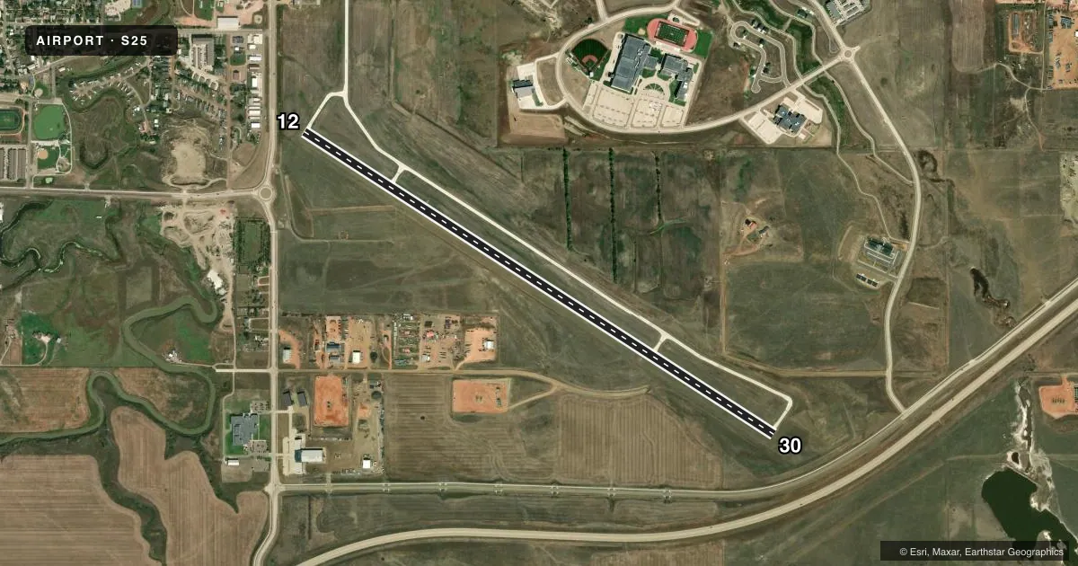
Airport sketch
Runways drawn to scale from FAA survey coordinates, rendered over satellite imagery. Not for navigation.
Approaches & charts
Services on the field
Fuel grades, oxygen, maintenance, ramp storage and lighting — as declared to the FAA by the airport operator.
Fuel & services
- Fuel
- 100LLA
- Oxygen (bottled)
- Not available
- Oxygen (bulk)
- Not available
- Airframe repair
- Minor
- Power plant repair
- Minor
- Other services
- AGRI,INSTR,RNTL
Ramp & ground
- Transient storage
- Tie-down
- Hangar
- Landing fee
- No fee published
- Customs
- Not available
- Lighting schedule
- SEE RMK
- Beacon schedule
- SS-SR
- Beacon
- White / Green (civil land)(WG)
- Wind indicator
- Lighted
- Segmented circle
- Yes
Fuel & FBOs
Cheapest 100LL and Jet A on the field and nearby. Always confirm with the FBO before taxi.
Airport notes
Surface conditions, obstructions, local procedures, lighting outages and other notes published with each FAA cycle.
General notes
- AFT WINTER STORMS CFM ARPT CONDS WITH AMGR; CALL (701) 300-3045 OR 701-570-2646.
- DEER & ANTELOPE ON OR INVOF ARPT.
- FOR CD CTC SALT LAKE ARTCC AT 801-320-2568.
Lighting notes
- ACTVT PAPI RWY 12 & 30 - CTAF. MIRL RWY 12/30 PRESET ON LOW INTST DUSK-DAWN, TO INCR INTST - CTAF.
Fuel notes
- AFULL SVC FUEL AVBL 800-1700 M-F AND SELF SVC WITH CREDIT CARD ALL OTHER HOURS.
Approach & departure obstructions
- 30+167'HILL LGTD W/OBS LGTS.
- 12ALSO +306 FT TWR 6600 FT FROM THR 4000 FT RIGHT OF CNTRLN EXTDD.
Other notes
- UNICOM LCTD AT SHERIFF'S OFFICE.
- 1ON CALL WEEKENDS AND NIGHTS
- MANAGERADDNL CONTACT - FBO PHONE 701-300-3045.
- AGRIFOR AGRI SVC CALL 701-570-2646.
VFR map & nearby airports
VFR sectional. Tap any ICAO chip to open that airport.
Key facts · S25
Answer card- ICAO
- S25
- Name
- WATFORD CITY MUNI
- Location
- WATFORD CITY, NORTH DAKOTA
- Elevation
- 2,135.1 ft MSL
- Traffic pattern altitude
- 3,135.1 ft MSL (1,000 AGL)
- Control tower
- Non-towered (use CTAF)
- Total runways
- 1
- Longest runway
- 12/30 · 6,550 ft
- Published ILS approaches
- 0
- Published frequencies
- 2
- Magnetic variation
- 7°
- Current flight rules
- VFR
- Current wind
- 070° at 4 kt
- Favored runway now
- RWY 12
Watford City Muni sits in Watford City, North Dakota. Field elevation is 2,135.1 ft MSL. The airport has one runway. Runway 12/30 is 6,550 ft long on concrete, which gives you plenty of pavement for most GA work. There is no control tower. CTAF and UNICOM are both 122.8. No ILS approaches are published here, so check the current FAA Chart Supplement for the latest approach and airport details before you go.
Pattern altitude is not published. Use the standard 1,000 ft AGL pattern unless local procedures or current airport guidance say otherwise. Watford AeroService is on the field. It carries 100LL and Jet A. Full service fuel is available from 0800 to 1700 Monday through Friday. Self-serve fuel with credit card is available outside those hours. The runway lighting is preset low from dusk to dawn. Use CTAF to raise the intensity or activate the PAPIs on runways 12 and 30.
A few operational items matter here. A 306-foot tower sits near the runway 12 end. A 167-foot lighted hill is near runway 30. Deer and antelope are also reported in the area. After winter storms, confirm airport conditions with the airport manager or the FBO before departure. For clearance delivery, contact Salt Lake ARTCC.