METAR & TAF 08D
Current METAR
Observed 16:35Z
K08D 271635Z AUTO 06005KT 10SM CLR 27/17 A2993 RMK AO2
- Wind
- 060° @ 5 kt
- Visibility
- 10 SM
- Temp / Dew
- 27°C / 17°C
- Altimeter
- 29.93 inHg
- Clouds
- CLR
- Density alt
- 4,217 ft
- Ceiling
- Unlimited
- Rules
- VFR
Airport info & contacts
Manager on record, flight service, ARTCC, attendance schedule and pattern altitude — published by the FAA and refreshed every 28 days.
Location
- From city
- 1 NM SW
- VFR sectional
- BILLINGS
- ARTCC
- ZMP · MINNEAPOLIS
- NOTAM facility
- GFK (NOTAM-D)
Airport manager
- Name
- STEVEN MARTENS
- Phone
- 701-629-0061
- Address
- PO BOX 252, STANLEY ND 58784
Flight service · Hours
- FSS GFK
- GRAND FORKS1-800-WX-BRIEF
- Attendance
- ON CALL
Frequencies
Tap any row to copy the frequency to your clipboard.
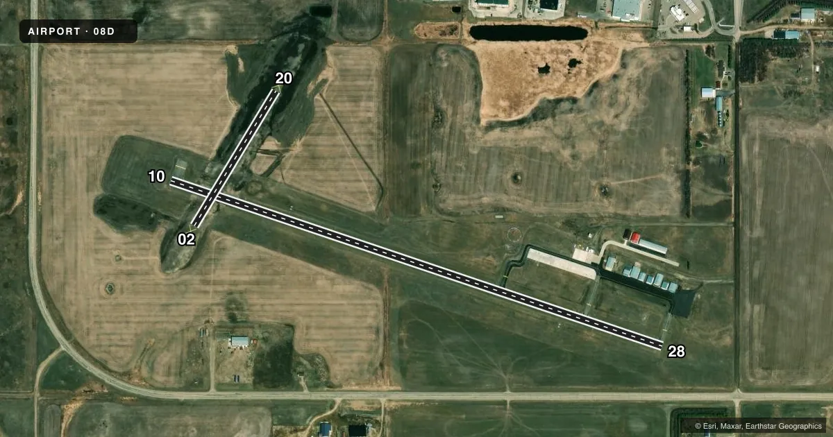
Runways & pattern
Full pagePattern entry · RWY 02
LEFT TRAFFIC| Runway | Heading (°M) | Length | Surface | Traffic |
|---|---|---|---|---|
| 10/28 | 101° / 281° | 3,900 ft | ASPH | Standard L |
| 02/20Favored | 24° / 204° | 1,185 ft | TURF | Standard L |
Runway end performance
| End | TORA | TODA | ASDA | LDA | VGSI | Approach lights | Obstruction |
|---|---|---|---|---|---|---|---|
| 10 | — | — | — | — | PAPI 2-box left(3°) | — | — |
| 28 | — | — | — | — | PAPI 2-box left(3°) | — | — |
Declared distances in feet. TORA = takeoff run available, TODA = takeoff distance, ASDA = accelerate-stop, LDA = landing distance.
Airport sketch
Runways drawn to scale from FAA survey coordinates, rendered over satellite imagery. Not for navigation.
Approaches & charts
Services on the field
Fuel grades, oxygen, maintenance, ramp storage and lighting — as declared to the FAA by the airport operator.
Fuel & services
- Fuel
- 100LLA+MOGAS
- Oxygen (bottled)
- Not available
- Oxygen (bulk)
- Not available
- Airframe repair
- Not available
- Power plant repair
- Not available
- Other services
- AGRI,INSTR
Ramp & ground
- Transient storage
- Tie-down
- Hangar
- Landing fee
- No fee published
- Customs
- Not available
- Lighting schedule
- SEE RMK
- Beacon schedule
- SS-SR
- Beacon
- White / Green (civil land)(WG)
- Wind indicator
- Lighted
- Segmented circle
- Yes
Fuel & FBOs
Cheapest 100LL and Jet A on the field and nearby. Always confirm with the FBO before taxi.
Airport notes
Surface conditions, obstructions, local procedures, lighting outages and other notes published with each FAA cycle.
General notes
- DUE TO SNOW NOV-MAR CALL 701-629-0061 OR 701-629-1244 TO CHECK ON RWY COND PRIOR TO USE.
- DEER & BIRDS ON & INVOF ARPT.
- FOR CD CTC MINNEAPOLIS ARTCC AT 651-463-5588.
Lighting notes
- ACTVT PAPI RWY 10 & 28; MIRL RWY 10/28 - CTAF.
Fuel notes
- 100LLSELF SVC FUEL AVBL H24 VIA CREDIT CARD.
Other notes
- OWNERCHAIRMAN: GREG JOHNSON 701-240-9635.
VFR map & nearby airports
VFR sectional. Tap any ICAO chip to open that airport.
Key facts · 08D
Answer card- ICAO
- 08D
- Name
- STANLEY MUNI
- Location
- STANLEY, NORTH DAKOTA
- Elevation
- 2,249.6 ft MSL
- Traffic pattern altitude
- 3,249.6 ft MSL (1,000 AGL)
- Control tower
- Non-towered (use CTAF)
- Total runways
- 2
- Longest runway
- 10/28 · 3,900 ft
- Published ILS approaches
- 0
- Published frequencies
- 1
- Magnetic variation
- 7°
- Current flight rules
- VFR
- Current wind
- 060° at 5 kt
- Favored runway now
- RWY 02
Stanley Muni is in Stanley, North Dakota. The field elevation is 2,249.6 ft MSL. It has two runways. The longest is runway 10/28 at 3,900 ft asphalt. Runway 02/20 is 1,185 ft turf. There is no control tower. CTAF is 122.9.
No ILS approaches are published here. The pattern altitude is not published, so a light piston pilot should plan on the standard 1,000 ft AGL unless the current Chart Supplement says otherwise. On the field, Stanley Municipal Airport carries AVGAS 100LL and Jet A Prist. Self-service 100LL is available 24 hours a day by credit card. PAPI is available on runways 10 and 28. Medium intensity runway lights on 10/28 are controlled by CTAF.
This is a North Dakota airport with weather and runway condition issues that can matter in winter. The published remarks say to call ahead for runway condition checks from November through March. Deer and birds are also reported on and near the airport. For clearance delivery, contact Minneapolis ARTCC. If you are planning a first stop here, pay attention to the turf runway length. Also note the lack of published ILS. Check the winter surface condition before you launch.