METAR & TAF 5B4
5B4 does not publish a METAR.
Showing the nearest reporting station: KMOT (MINOT INTL) · 50.8 NM away. Conditions at 5B4 may differ.
METAR · KMOT
Observed 10:54Z
KMOT 271054Z AUTO 23009KT 10SM CLR 18/16 A2987 RMK AO2 SLP103 T01780161
- Wind
- 230° @ 9 kt
- Visibility
- 10 SM
- Temp / Dew
- 18°C / 16°C
- Altimeter
- 29.87 inHg
- Clouds
- CLR
- Density alt
- 2,846 ft
- Ceiling
- Unlimited
- Rules
- VFR
Airport info & contacts
Manager on record, flight service, ARTCC, attendance schedule and pattern altitude — published by the FAA and refreshed every 28 days.
Location
- From city
- 1 NM N
- VFR sectional
- BILLINGS
- ARTCC
- ZMP · MINNEAPOLIS
- NOTAM facility
- GFK (NOTAM-D)
Airport manager
- Name
- WAYNE JACOBSON
- Phone
- 701-339-1574
- Address
- PO BOX 173, BOWBELLS ND 58721
Flight service · Hours
- FSS GFK
- GRAND FORKS1-800-WX-BRIEF
- Attendance
- Unattended
Frequencies
Tap any row to copy the frequency to your clipboard.
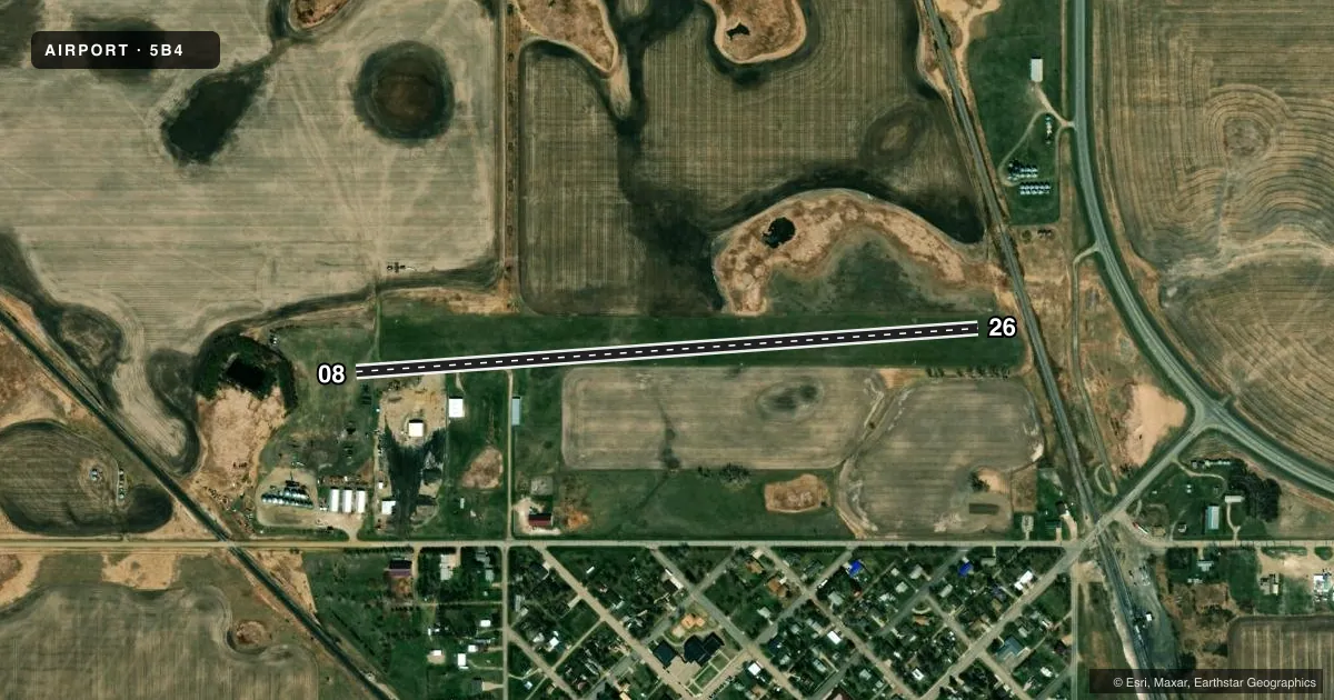
Runways & pattern
Full pagePattern entry · RWY 26
LEFT TRAFFICRunway end performance
| End | TORA | TODA | ASDA | LDA | VGSI | Approach lights | Obstruction |
|---|---|---|---|---|---|---|---|
| 08 | — | — | — | — | — | — | 48', trees, 490' from thr, 112' R of cntrln, slope 10 |
| 26 | — | — | — | — | — | — | 29', rr, 100' from thr, 135' R of cntrln, slope 3 |
Declared distances in feet. TORA = takeoff run available, TODA = takeoff distance, ASDA = accelerate-stop, LDA = landing distance.
Airport sketch
Runways drawn to scale from FAA survey coordinates, rendered over satellite imagery. Not for navigation.
Approaches & charts
Services on the field
Fuel grades, oxygen, maintenance, ramp storage and lighting — as declared to the FAA by the airport operator.
Fuel & services
- Fuel
- Not available
- Oxygen (bottled)
- Not available
- Oxygen (bulk)
- Not available
- Airframe repair
- Not available
- Power plant repair
- Not available
Ramp & ground
- Transient storage
- Tie-down
- Landing fee
- No fee published
- Wind indicator
- Yes
- Segmented circle
- No
Fuel & FBOs
Cheapest 100LL and Jet A on the field and nearby. Always confirm with the FBO before taxi.
Airport notes
Surface conditions, obstructions, local procedures, lighting outages and other notes published with each FAA cycle.
General notes
- RY IREG & SOFT WHEN WET WITH WATER PONDING POSSIBLE.
- IREG SNOW REMOVAL; CFM RY COND PRIOR TO USE; CALL (701) 339-1574 OR 701-377-2731.
- TWY SOFT WHEN WET WITH 1 INCH DRAINAGE SWALE.
- FOR CD CTC MINNEAPOLIS ARTCC AT 651-463-5588.
Approach & departure obstructions
- 26DSPLCD THR MKD ONLY WITH DALGT BLK & WHT CNS.
- 08RWY 8/26 - MRKD W/ BLK & WHT CNS.
- 26+25 FT RLRD 520 FT FM DTHR; 135 FT L/R CL; 20:1 APCH SLP.
VFR map & nearby airports
VFR sectional. Tap any ICAO chip to open that airport.
Key facts · 5B4
Answer card- ICAO
- 5B4
- Name
- BOWBELLS MUNI
- Location
- BOWBELLS, NORTH DAKOTA
- Elevation
- 1,955 ft MSL
- Traffic pattern altitude
- 2,955 ft MSL (1,000 AGL)
- Control tower
- Non-towered (use CTAF)
- Total runways
- 1
- Longest runway
- 08/26 · 2,900 ft
- Published ILS approaches
- 0
- Published frequencies
- 1
- Magnetic variation
- 11°
- Current flight rules
- VFR
- Current wind
- 230° at 9 kt
- Favored runway now
- RWY 26
Bowbells Muni sits in Bowbells, North Dakota. The field elevation is 1,955 ft MSL. It has one runway. The longest is 08/26 at 2,900 ft on turf. There is no control tower. CTAF is 122.9.
No ILS approaches are published here. Pattern altitude is not published, so use the standard 1,000 ft AGL for light piston traffic unless local procedures say otherwise. That puts the pattern at 2,955 ft MSL based on the published field elevation.
This is a turf field, so wet conditions matter. The published remarks say the runway can be irregular and soft when wet. Water ponding is possible. Taxiways can also be soft when wet, with a 1 inch drainage swale. Snow removal is irregular, so confirm runway condition before you go. The runway is marked with black and white cones. The displaced threshold on runway 26 is marked only with daylight black and white cones.
There are no on-field FBOs listed. For current fuel or service options, contact the airport operator directly or call the field on CTAF for current availability. For clearance delivery, contact Minneapolis ARTCC at 651-463-5588. The runway has a 25-foot railroad obstruction 520 feet from the displaced threshold on the 26 end, with a 20 to 1 approach slope. Plan your arrival with that in mind.