METAR & TAF D64
D64 does not publish a METAR.
Showing the nearest reporting station: KMOT (MINOT INTL) · 40.5 NM away. Conditions at D64 may differ.
METAR · KMOT
Observed 21:54Z
KMOT 232154Z 18008KT 10SM CLR 30/16 A2992 RMK AO2 SLP123 T03000156
- Wind
- 180° @ 8 kt
- Visibility
- 10 SM
- Temp / Dew
- 30°C / 16°C
- Altimeter
- 29.92 inHg
- Clouds
- CLR
- Density alt
- 3,650 ft
- Ceiling
- Unlimited
- Rules
- VFR
Airport info & contacts
Manager on record, flight service, ARTCC, attendance schedule and pattern altitude — published by the FAA and refreshed every 28 days.
Location
- From city
- 0 NM W
- VFR sectional
- BILLINGS
- ARTCC
- ZMP · MINNEAPOLIS
- NOTAM facility
- GFK (NOTAM-D)
Airport manager
- Name
- CHAD TOFTELAND
- Phone
- (701) 263-1304
- Address
- 1325 99TH ST SW, WESTHOPE ND 58793
Flight service · Hours
- FSS GFK
- GRAND FORKS1-800-WX-BRIEF
- Attendance
- Unattended
Frequencies
Tap any row to copy the frequency to your clipboard.
Runways & pattern
Full pagePattern entry · RWY 14
LEFT TRAFFICRunway end performance
| End | TORA | TODA | ASDA | LDA | VGSI | Approach lights | Obstruction |
|---|---|---|---|---|---|---|---|
| 32 | — | — | — | — | — | — | 50', tree, 900' from thr, 180' R of cntrln, slope 13 |
Declared distances in feet. TORA = takeoff run available, TODA = takeoff distance, ASDA = accelerate-stop, LDA = landing distance.
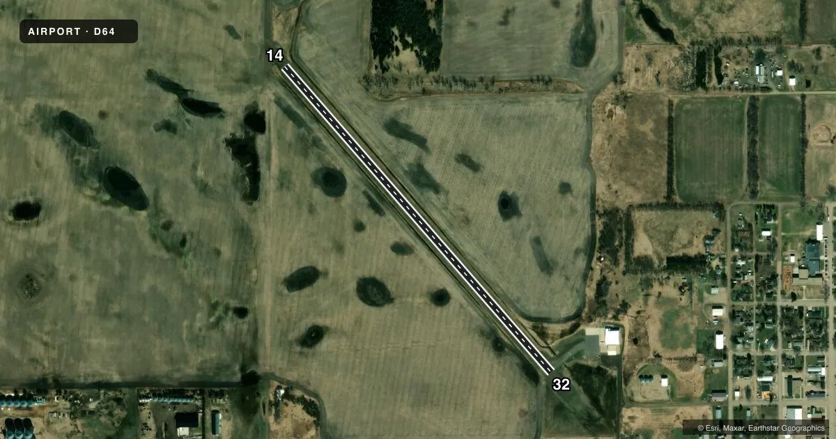
Airport sketch
Runways drawn to scale from FAA survey coordinates, rendered over satellite imagery. Not for navigation.
Approaches & charts
Services on the field
Fuel grades, oxygen, maintenance, ramp storage and lighting — as declared to the FAA by the airport operator.
Fuel & services
- Fuel
- Not available
- Oxygen (bottled)
- Not available
- Oxygen (bulk)
- Not available
- Airframe repair
- Not available
- Power plant repair
- Not available
- Other services
- AGRI
Ramp & ground
- Transient storage
- Tie-down
- Hangar
- Landing fee
- No fee published
- Customs
- Not available
- Wind indicator
- Yes
- Segmented circle
- No
Fuel & FBOs
Cheapest 100LL and Jet A on the field and nearby. Always confirm with the FBO before taxi.
Airport notes
Surface conditions, obstructions, local procedures, lighting outages and other notes published with each FAA cycle.
General notes
- CONFIRM SNOW REMOVAL & WINTER CONDITIONS BEFORE USE; CALL (701) 263-1304.
- -2' DITCH 65' L/R OF RY CNTRLN PARALLEL ON BOTH SIDES
- RWY 32 +35 FT POWERLINE 800 FT FM THR 175 FT L, APCH RATIO 17:1; +30 FT POLE 800 FT FM THR 175 FT R, APCH RATIO 20:1.
- DEER BIRDS ON OR NEAR VICINITY OF AIRPORT.
- FOR CD CTC MINNEAPOLIS ARTCC AT 651-463-5588.
Other notes
- OWNERBRAD BERENTSON, CHRMN OF APT AUTH.
- MANAGERADDL PHONE (701) 263-5399
VFR map & nearby airports
VFR sectional. Tap any ICAO chip to open that airport.
Key facts · D64
Answer card- ICAO
- D64
- Name
- WESTHOPE MUNI
- Location
- WESTHOPE, NORTH DAKOTA
- Elevation
- 1,492 ft MSL
- Traffic pattern altitude
- 2,492 ft MSL (1,000 AGL)
- Control tower
- Non-towered (use CTAF)
- Total runways
- 1
- Longest runway
- 14/32 · 3,000 ft
- Published ILS approaches
- 0
- Published frequencies
- 1
- Magnetic variation
- 10°
- Current flight rules
- VFR
- Current wind
- 180° at 8 kt
- Favored runway now
- RWY 14
Westhope Muni (D64) sits in Westhope, North Dakota. The field elevation is 1,492 ft MSL. It has one runway. Runway 14/32 is 3,000 ft of asphalt, which is the longest runway on the field. There is no control tower. CTAF is 122.9.
No ILS approaches are published here. Pattern altitude is not published, so use the standard 1,000 ft AGL for light piston operations unless the current FAA Chart Supplement says otherwise. That puts the pattern at about 2,492 ft MSL based on the field elevation, but verify before you fly. The published remarks matter here. Runway 32 has a powerline and a pole near the approach end. There is also a ditch running parallel to both sides of the runway. Deer and birds are reported in the area, so keep a sharp scan on arrival and departure. For clearance delivery, contact Minneapolis ARTCC. There are no on-field FBOs listed, so call the airport operator directly before arrival if you need fuel or ground support. Winter conditions and snow removal should also be confirmed by phone before use.