METAR & TAF S28
S28 does not publish a METAR.
Showing the nearest reporting station: KRUG (RUGBY MUNI) · 36.4 NM away. Conditions at S28 may differ.
METAR · KRUG
Observed 13:35Z
KRUG 261335Z AUTO 00000KT 9SM CLR 23/21 A2974 RMK AO2
- Wind
- 000° @ 0 kt
- Visibility
- 9 SM
- Temp / Dew
- 23°C / 21°C
- Altimeter
- 29.74 inHg
- Clouds
- CLR
- Density alt
- 4,056 ft
- Ceiling
- Unlimited
- Rules
- VFR
Airport info & contacts
Manager on record, flight service, ARTCC, attendance schedule and pattern altitude — published by the FAA and refreshed every 28 days.
Location
- From city
- 12 NM N
- VFR sectional
- TWIN CITIES
- ARTCC
- ZMP · MINNEAPOLIS
- NOTAM facility
- GFK (NOTAM-D)
Airport manager
- Name
- KYLE WANNER
- Phone
- 701-328-9650
- Address
- PO BOX 5020, BISMARCK ND 58502
Flight service · Hours
- FSS GFK
- GRAND FORKS1-800-WX-BRIEF
- Attendance
- Unattended
Frequencies
Tap any row to copy the frequency to your clipboard.
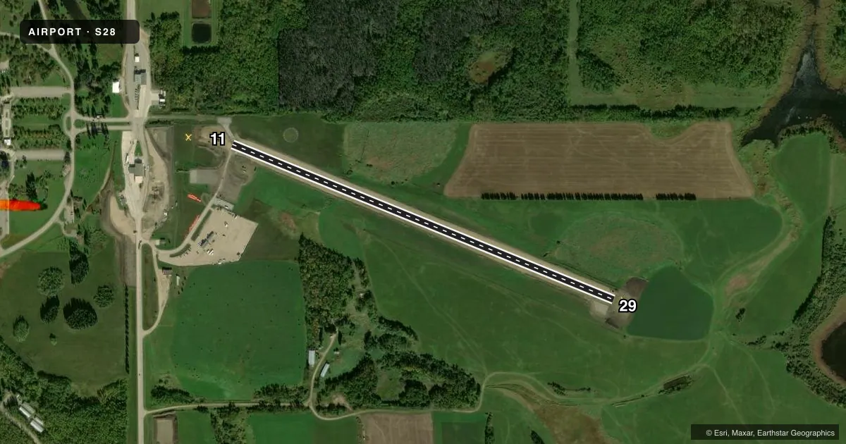
Runways & pattern
Full pagePattern entry · RWY 11
LEFT TRAFFICRunway end performance
| End | TORA | TODA | ASDA | LDA | VGSI | Approach lights | Obstruction |
|---|---|---|---|---|---|---|---|
| 11 | 3,005' | 3,005' | — | — | — | — | — |
| 29 | 3,005' | 3,005' | — | — | — | — | — |
Declared distances in feet. TORA = takeoff run available, TODA = takeoff distance, ASDA = accelerate-stop, LDA = landing distance.
Airport sketch
Runways drawn to scale from FAA survey coordinates, rendered over satellite imagery. Not for navigation.
Approaches & charts
Services on the field
Fuel grades, oxygen, maintenance, ramp storage and lighting — as declared to the FAA by the airport operator.
Fuel & services
- Fuel
- Not available
- Oxygen (bottled)
- Not available
- Oxygen (bulk)
- Not available
- Airframe repair
- Not available
- Power plant repair
- Not available
Ramp & ground
- Transient storage
- Tie-down
- Landing fee
- No fee published
- Customs
- Not available
- Wind indicator
- Yes
- Segmented circle
- Yes
Fuel & FBOs
Cheapest 100LL and Jet A on the field and nearby. Always confirm with the FBO before taxi.
Airport notes
Surface conditions, obstructions, local procedures, lighting outages and other notes published with each FAA cycle.
General notes
- UNICOM IN CUSTOMS OFFICE.
- SNOW PLOWED IRREG - CONFIRM WINTER COND PRIOR TO USE 701-328-9650 MON-FRI 0800-1700.
- DEER & BIRDS ON & INVOF ARPT.
- RY 11 HAS -20 FT DROPOFF 400 FT FM THLD.
- (A76) US & CANADIAN CUSTOMS SVC AVBL.
- FOR CD CTC MINNEAPOLIS ARTCC AT 651-463-5588.
Approach & departure obstructions
- 1113 FT PSBL ACFT 35 FT L OF RWY 11 EXTDD CNTRLN & THR.
- 1180 FT TOWER VIOLATES TRSNL SFC ON N SIDE OF RWY PROTECTION ZONE.
Other notes
- 1CUSTOMS PSNL ONW/DALGT/KNOW ARPT CONDS. 701-263-4513 (US) AND 204-534-6820 (CANADIAN).
- MANAGERADL EMERG CTC AMGR KYLE WANNER 701-425-5926 OR GRANT ERWIN 701-595-3856.
VFR map & nearby airports
VFR sectional. Tap any ICAO chip to open that airport.
Key facts · S28
Answer card- ICAO
- S28
- Name
- INTL PEACE GARDEN
- Location
- DUNSEITH, NORTH DAKOTA
- Elevation
- 2,316.8 ft MSL
- Traffic pattern altitude
- 3,316.8 ft MSL (1,000 AGL)
- Control tower
- Non-towered (use CTAF)
- Total runways
- 1
- Longest runway
- 11/29 · 3,005 ft
- Published ILS approaches
- 0
- Published frequencies
- 2
- Magnetic variation
- 9°
- Current flight rules
- VFR
- Current wind
- 000° at 0 kt
- Favored runway now
- –
INTL PEACE GARDEN is in Dunseith, North Dakota near the Canadian border. Field elevation is 2,316.8 ft MSL. The airport has one runway, 11/29, which is 3,005 ft long with asphalt pavement. There is no control tower. CTAF and UNICOM are both 122.8. No ILS approaches are published here.
Pattern altitude is not published. Use the standard 1,000 ft AGL pattern for light piston traffic unless the current Chart Supplement or local conditions say otherwise. That puts the pattern at about 3,316.8 ft MSL based on the field elevation. Customs personnel are on watch daily. U.S. and Canadian customs service is available on field. The UNICOM frequency is located in the customs office. For clearance delivery, contact Minneapolis ARTCC.
First-time pilots should pay attention to the published runway 11 hazards. There is an 80-foot tower north of the runway protection zone. There is also a 20-foot dropoff 400 feet from the runway 11 threshold. A possible aircraft is reported near the extended centerline for runway 11. Deer and birds are present on and near the airport. Snow is plowed irregularly. Check winter conditions before you go.