METAR & TAF 9D7
Current METAR
Observed 13:35Z
K9D7 271335Z AUTO 30006KT 3SM BR CLR 21/21 A2988 RMK AO2
- Wind
- 300° @ 6 kt
- Visibility
- 3 SM
- Temp / Dew
- 21°C / 21°C
- Altimeter
- 29.88 inHg
- Clouds
- CLR
- Density alt
- 2,607 ft
- Ceiling
- Unlimited
- Rules
- MVFR
Airport info & contacts
Manager on record, flight service, ARTCC, attendance schedule and pattern altitude — published by the FAA and refreshed every 28 days.
Location
- From city
- 1 NM W
- VFR sectional
- TWIN CITIES
- ARTCC
- ZMP · MINNEAPOLIS
- NOTAM facility
- 9D7 (NOTAM-D)
Airport manager
- Name
- ROLLIE BJORNSTAD
- Phone
- 701-739-8026
- Address
- P.O. BOX 396, CANDO ND 58324
Flight service · Hours
- FSS GFK
- GRAND FORKS1-800-WX-BRIEF
- Attendance
- Unattended
Frequencies
Tap any row to copy the frequency to your clipboard.
Runways & pattern
Full pagePattern entry · RWY 34
LEFT TRAFFICRunway end performance
| End | TORA | TODA | ASDA | LDA | VGSI | Approach lights | Obstruction |
|---|---|---|---|---|---|---|---|
| 16 | — | — | — | — | PAPI 2-box left(3°) | — | — |
| 34 | — | — | — | — | PAPI 2-box left(3°) | — | — |
Declared distances in feet. TORA = takeoff run available, TODA = takeoff distance, ASDA = accelerate-stop, LDA = landing distance.
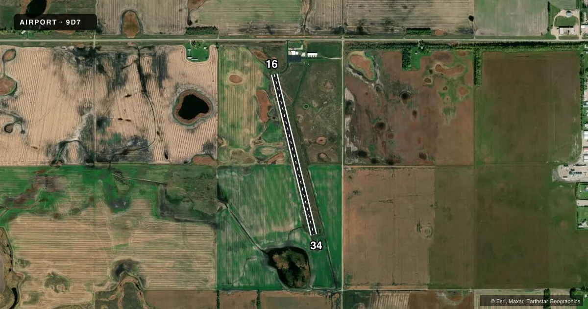
Airport sketch
Runways drawn to scale from FAA survey coordinates, rendered over satellite imagery. Not for navigation.
Approaches & charts
Services on the field
Fuel grades, oxygen, maintenance, ramp storage and lighting — as declared to the FAA by the airport operator.
Fuel & services
- Fuel
- Not available
- Oxygen (bottled)
- Not available
- Oxygen (bulk)
- Not available
- Airframe repair
- Not available
- Power plant repair
- Not available
- Other services
- AGRI
Ramp & ground
- Transient storage
- Tie-down
- Landing fee
- No fee published
- Customs
- Not available
- Lighting schedule
- SEE RMK
- Beacon schedule
- SS-SR
- Beacon
- White / Green (civil land)(WG)
- Wind indicator
- Lighted
- Segmented circle
- Yes
Fuel & FBOs
Cheapest 100LL and Jet A on the field and nearby. Always confirm with the FBO before taxi.
Airport notes
Surface conditions, obstructions, local procedures, lighting outages and other notes published with each FAA cycle.
General notes
- IREG SNOW REMOVAL WINTER MONTHS; CONFIRM WINTER CONDS PRIOR TO USE WITH ARPT MGR.
- MIGRATORY WATERFOWL INVOF ARPT MAR-APR & SEP-OCT.
- FOR CD CTC MINNEAPOLIS ARTCC AT 651-463-5588.
Lighting notes
- ACTVT PAPI 16 & 34; MIRL RWY 16/34 - CTAF.
Other notes
- EXISTED PRIOR TO 1959.
- OWNERROLLIE BJORNSTAD - CHRMN ARPT AUTH.
- MANAGERADDITIONAL PHONE NUMBERS 701-968-3043 OR 701-303-0824
- AGRIFOR AGRI SVC CALL (701) 968-3043/303-0824.
VFR map & nearby airports
VFR sectional. Tap any ICAO chip to open that airport.
Key facts · 9D7
Answer card- ICAO
- 9D7
- Name
- CANDO MUNI
- Location
- CANDO, NORTH DAKOTA
- Elevation
- 1,481.5 ft MSL
- Traffic pattern altitude
- 2,481.5 ft MSL (1,000 AGL)
- Control tower
- Non-towered (use CTAF)
- Total runways
- 1
- Longest runway
- 16/34 · 3,500 ft
- Published ILS approaches
- 0
- Published frequencies
- 1
- Magnetic variation
- 6°
- Current flight rules
- MVFR
- Current wind
- 300° at 6 kt
- Favored runway now
- RWY 34
Cando Muni Airport sits in Cando, North Dakota. The field elevation is 1,481.5 ft MSL. It has one runway, 16/34, which is 3,500 ft long and asphalt. The airport is not towered. CTAF is 122.9. No ILS approaches are published here.
Pattern altitude is not published. Use 1,000 ft AGL as the standard light piston pattern unless the current Chart Supplement or airport manager says otherwise. The runway lighting is useful for night work. PAPI is available on both runway ends. Medium intensity runway lights are also installed on 16 and 34.
There are no on-field FBOs listed. If you need fuel or local services, contact the airport manager directly before arrival. Published remarks also note irregular snow removal in winter. Check conditions before you go if the runway may be snow covered or slick. Migratory waterfowl can be in the area in March through April and again in September through October. That matters on departure and arrival. For clearance delivery, contact Minneapolis ARTCC. The airport has been in place since before 1959. Pilots should plan for a small non-towered field with seasonal winter and wildlife considerations.