METAR & TAF 6D3
6D3 does not publish a METAR.
Showing the nearest reporting station: KDVL (DEVILS LAKE RGNL) · 26.1 NM away. Conditions at 6D3 may differ.
METAR · KDVL
Observed 04:56Z
KDVL 250456Z AUTO 33003KT 10SM CLR 22/19 A2978 RMK AO2 SLP081 T02220194 403440189
- Wind
- 330° @ 3 kt
- Visibility
- 10 SM
- Temp / Dew
- 22°C / 19°C
- Altimeter
- 29.78 inHg
- Clouds
- CLR
- Density alt
- 2,998 ft
- Ceiling
- Unlimited
- Rules
- VFR
Airport info & contacts
Manager on record, flight service, ARTCC, attendance schedule and pattern altitude — published by the FAA and refreshed every 28 days.
Location
- From city
- 1 NM N
- VFR sectional
- TWIN CITIES
- ARTCC
- ZMP · MINNEAPOLIS
- NOTAM facility
- GFK (NOTAM-D)
Airport manager
- Name
- RICHARD SLATER
- Phone
- 701-739-4875
- Address
- P.O. BOX 64, MADDOCK ND 58348
Flight service · Hours
- FSS GFK
- GRAND FORKS1-800-WX-BRIEF
- Attendance
- ON CALL
Frequencies
Tap any row to copy the frequency to your clipboard.
Runways & pattern
Full pagePattern entry · RWY 30
LEFT TRAFFICRunway end performance
| End | TORA | TODA | ASDA | LDA | VGSI | Approach lights | Obstruction |
|---|---|---|---|---|---|---|---|
| 12 | — | — | — | — | — | — | 19', road, 600' from thr, 50' R of cntrln, slope 20 |
Declared distances in feet. TORA = takeoff run available, TODA = takeoff distance, ASDA = accelerate-stop, LDA = landing distance.
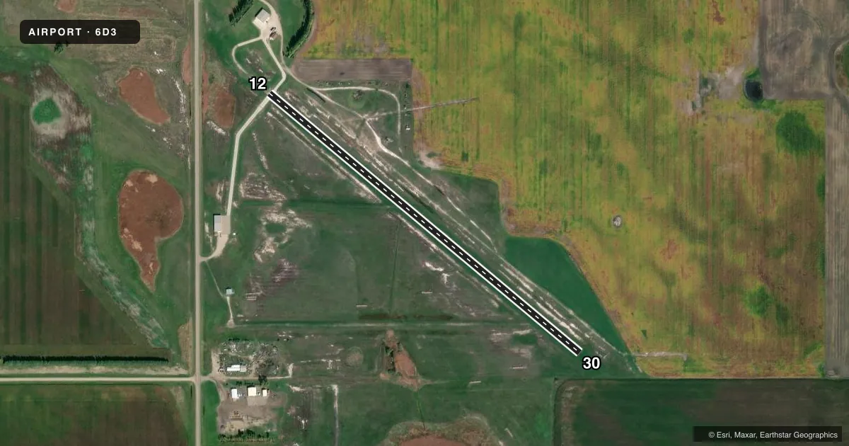
Airport sketch
Runways drawn to scale from FAA survey coordinates, rendered over satellite imagery. Not for navigation.
Approaches & charts
Services on the field
Fuel grades, oxygen, maintenance, ramp storage and lighting — as declared to the FAA by the airport operator.
Fuel & services
- Fuel
- Not available
- Oxygen (bottled)
- Not available
- Oxygen (bulk)
- Not available
- Airframe repair
- Not available
- Power plant repair
- Not available
- Other services
- AGRI,INSTR,SALES
Ramp & ground
- Transient storage
- Tie-down
- Hangar
- Landing fee
- No fee published
- Customs
- Not available
- Lighting schedule
- SEE RMK
- Wind indicator
- Yes
- Segmented circle
- No
Fuel & FBOs
Cheapest 100LL and Jet A on the field and nearby. Always confirm with the FBO before taxi.
Airport notes
Surface conditions, obstructions, local procedures, lighting outages and other notes published with each FAA cycle.
General notes
- IREG SNOW REMOVAL; CFM ARPT COND WITH MGR DURING WINTER MONTHS.
- MIDFIELD E/W TURF TWY OPEN TO WEST SIDE APN AND HNGR. UNEVEN SFC.
- DEER & BIRDS ON OR INVOF ARPT.
- FOR CD CTC MINNEAPOLIS ARTCC AT 651-463-5588.
Lighting notes
- ACTVT MIRL RWY 12/30 - CTAF.
Approach & departure obstructions
- 12SEASONAL 7 FT CORNFIELD JULY-SEPT 200 FT FM RWY THR 100 FT L OF CNTRLN 0:1 SLOPE WHEN PRESENT.
Other notes
- 1FOR ATTENDANT CALL (701) 739-4875.
- MANAGERADDNL PHONE AMGR, 701-438-2444.
- OWNERJASON LEE CHAIRPERSON OF ARPT AUTH.
VFR map & nearby airports
VFR sectional. Tap any ICAO chip to open that airport.
Key facts · 6D3
Answer card- ICAO
- 6D3
- Name
- MADDOCK MUNI
- Location
- MADDOCK, NORTH DAKOTA
- Elevation
- 1,600 ft MSL
- Traffic pattern altitude
- 2,600 ft MSL (1,000 AGL)
- Control tower
- Non-towered (use CTAF)
- Total runways
- 1
- Longest runway
- 12/30 · 3,000 ft
- Published ILS approaches
- 0
- Published frequencies
- 1
- Magnetic variation
- 9°
- Current flight rules
- VFR
- Current wind
- 330° at 3 kt
- Favored runway now
- RWY 30
Maddock Muni sits near Maddock, North Dakota. Field elevation is 1,600 ft MSL. The airport has one runway. Runway 12/30 is 3,000 ft long with concrete pavement. The field is not towered. CTAF is 122.9. Medium intensity runway lights on 12/30 are activated by CTAF.
No ILS approaches are published here. Pattern altitude is not published in the facts, so use the standard 1,000 ft AGL unless the current Chart Supplement says otherwise. For this field that works out to about 2,600 ft MSL. The runway headings are 130° and 310° magnetic. That matters if you are planning a crosswind landing or a night arrival.
There are no on-field FBOs listed in the facts. FBO options vary. Contact the airport operator directly before arrival, or call the field on CTAF/UNICOM for current FBO availability. Published remarks also note irregular snow removal in winter. Check field condition before you go if the surface matters for your aircraft. There is a seasonal cornfield near the runway 12 end from July through September. Deer and birds are also reported in the area. The midfield east-west turf taxiway is open to the west side apron and hangar, but the surface is uneven. For clearance delivery, contact Minneapolis ARTCC.