METAR & TAF D31
D31 does not publish a METAR.
Showing the nearest reporting station: KDVL (DEVILS LAKE RGNL) · 22.1 NM away. Conditions at D31 may differ.
METAR · KDVL
Observed 08:56Z
KDVL 260856Z AUTO 16004KT 10SM CLR 23/23 A2978 RMK AO2 SLP078 T02330228 56011
- Wind
- 160° @ 4 kt
- Visibility
- 10 SM
- Temp / Dew
- 23°C / 23°C
- Altimeter
- 29.78 inHg
- Clouds
- CLR
- Density alt
- 3,004 ft
- Ceiling
- Unlimited
- Rules
- VFR
Airport info & contacts
Manager on record, flight service, ARTCC, attendance schedule and pattern altitude — published by the FAA and refreshed every 28 days.
Location
- From city
- 2 NM E
- VFR sectional
- TWIN CITIES
- ARTCC
- ZMP · MINNEAPOLIS
- NOTAM facility
- GFK (NOTAM-D)
Airport manager
- Name
- ERIKA KENNER
- Phone
- 406-581-1188
- Address
- 440 6TH AVE SE, LEEDS ND 58346
Flight service · Hours
- FSS GFK
- GRAND FORKS1-800-WX-BRIEF
- Attendance
- Unattended
Frequencies
Tap any row to copy the frequency to your clipboard.
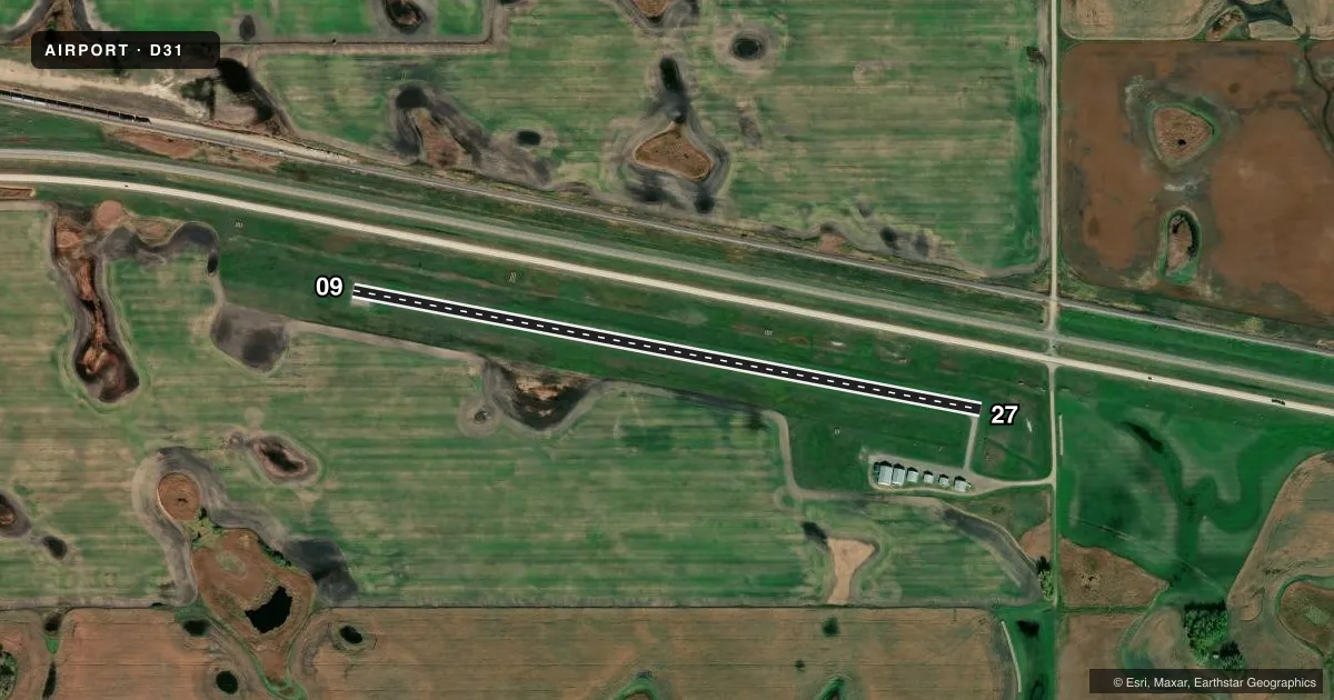
Runways & pattern
Full pagePattern entry · RWY 09
LEFT TRAFFICRunway end performance
| End | TORA | TODA | ASDA | LDA | VGSI | Approach lights | Obstruction |
|---|---|---|---|---|---|---|---|
| 27 | — | — | — | — | — | — | 13', road, 320' from thr, 150' R of cntrln, slope 9 |
Declared distances in feet. TORA = takeoff run available, TODA = takeoff distance, ASDA = accelerate-stop, LDA = landing distance.
Airport sketch
Runways drawn to scale from FAA survey coordinates, rendered over satellite imagery. Not for navigation.
Approaches & charts
Services on the field
Fuel grades, oxygen, maintenance, ramp storage and lighting — as declared to the FAA by the airport operator.
Fuel & services
- Fuel
- Not available
- Oxygen (bottled)
- Not available
- Oxygen (bulk)
- Not available
- Airframe repair
- Not available
- Power plant repair
- Not available
- Other services
- AGRI
Ramp & ground
- Transient storage
- Not published
- Lighting schedule
- SS-SR
- Wind indicator
- Yes
- Segmented circle
- Yes
Fuel & FBOs
Cheapest 100LL and Jet A on the field and nearby. Always confirm with the FBO before taxi.
Airport notes
Surface conditions, obstructions, local procedures, lighting outages and other notes published with each FAA cycle.
General notes
- CFM WINTER CONDS & SNOW REMOVAL CALL 406-581-1188.
- MIGRATORY WATERFOWL ON AND INVOF ARPT.
- RY 27 SAFETY AREA 200 FT OUT IS ROUGH WITH CLUMPY GRASS.
- FOR CD CTC MINNEAPOLIS ARTCC AT 651-463-5588.
Runway surface & condition
- 09/27RWY 9/27 NSTD SOLAR LIGHTS.
Other notes
- OWNERERIKA KENNER, CHAIR OF ARPT AUTH
VFR map & nearby airports
VFR sectional. Tap any ICAO chip to open that airport.
Key facts · D31
Answer card- ICAO
- D31
- Name
- LEEDS MUNI
- Location
- LEEDS, NORTH DAKOTA
- Elevation
- 1,508 ft MSL
- Traffic pattern altitude
- 2,508 ft MSL (1,000 AGL)
- Control tower
- Non-towered (use CTAF)
- Total runways
- 1
- Longest runway
- 09/27 · 3,000 ft
- Published ILS approaches
- 0
- Published frequencies
- 2
- Magnetic variation
- 9°
- Current flight rules
- VFR
- Current wind
- 160° at 4 kt
- Favored runway now
- RWY 09
Leeds Muni sits in Leeds, North Dakota. The field elevation is 1,508 ft MSL. It has one runway. Runway 09/27 is 3,000 ft long with asphalt surface. The airport is non-towered. CTAF and UNICOM are both 122.8. No ILS approaches are published here.
The pattern altitude is not published. Use the standard 1,000 ft AGL pattern unless the current Chart Supplement says otherwise. That puts the light piston pattern at about 2,508 ft MSL. Runway 9/27 has nonstandard solar lights, so plan for that on a night or low-light arrival. The remarks also call out winter conditions and snow removal. Call ahead before a cold-weather trip. The published notes mention rough grass outside the Runway 27 safety area. Migratory waterfowl are also reported on and near the airport, so keep your scan active on approach and departure.
There are no on-field FBOs listed in the facts. Contact the airport operator directly or call the field on CTAF or UNICOM for current service status. If you need clearance delivery, Minneapolis ARTCC is listed in the remarks. For a first visit, the main things to watch are the weather, wildlife and the runway lighting setup.