METAR & TAF 2H9
2H9 does not publish a METAR.
Showing the nearest reporting station: KRUG (RUGBY MUNI) · 17.9 NM away. Conditions at 2H9 may differ.
METAR · KRUG
Observed 22:55Z
KRUG 252255Z AUTO 14008KT 8SM CLR 30/21 A2981 RMK AO2
- Wind
- 140° @ 8 kt
- Visibility
- 8 SM
- Temp / Dew
- 30°C / 21°C
- Altimeter
- 29.81 inHg
- Clouds
- CLR
- Density alt
- 3,949 ft
- Ceiling
- Unlimited
- Rules
- VFR
Airport info & contacts
Manager on record, flight service, ARTCC, attendance schedule and pattern altitude — published by the FAA and refreshed every 28 days.
Location
- From city
- 1 NM W
- VFR sectional
- TWIN CITIES
- ARTCC
- ZMP · MINNEAPOLIS
- NOTAM facility
- GFK (NOTAM-D)
Airport manager
- Name
- RICHARD ARSTEIN
- Phone
- 701-201-0504
- Address
- BOX 367, ROLETTE ND 58366
Flight service · Hours
- FSS GFK
- GRAND FORKS1-800-WX-BRIEF
- Attendance
- Unattended
Frequencies
Tap any row to copy the frequency to your clipboard.
Runways & pattern
Full pagePattern entry · RWY 15
LEFT TRAFFICRunway end performance
| End | TORA | TODA | ASDA | LDA | VGSI | Approach lights | Obstruction |
|---|---|---|---|---|---|---|---|
| 33 | — | — | — | — | — | — | 19', road, 440' from thr, 150' R of cntrln, slope 12 |
Declared distances in feet. TORA = takeoff run available, TODA = takeoff distance, ASDA = accelerate-stop, LDA = landing distance.
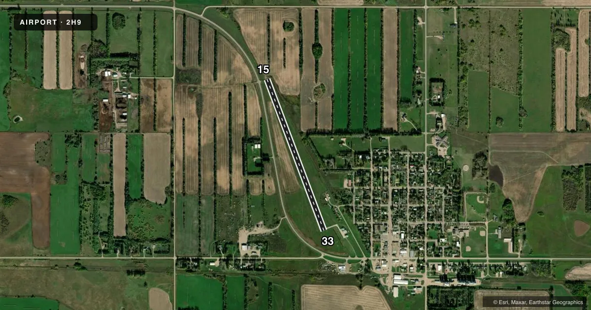
Airport sketch
Runways drawn to scale from FAA survey coordinates, rendered over satellite imagery. Not for navigation.
Approaches & charts
Services on the field
Fuel grades, oxygen, maintenance, ramp storage and lighting — as declared to the FAA by the airport operator.
Fuel & services
- Fuel
- Not available
- Oxygen (bottled)
- Not available
- Oxygen (bulk)
- Not available
- Airframe repair
- Not available
- Power plant repair
- Not available
- Other services
- AGRI
Ramp & ground
- Transient storage
- Tie-down
- Landing fee
- No fee published
- Wind indicator
- Yes
- Segmented circle
- No
Fuel & FBOs
Cheapest 100LL and Jet A on the field and nearby. Always confirm with the FBO before taxi.
Airport notes
Surface conditions, obstructions, local procedures, lighting outages and other notes published with each FAA cycle.
General notes
- SNOW REMOVAL IREG; CONFIRM WINTER CONDITIONS WITH AMGR - CALL 701-246-3395.
- RY 15 +21 FT ROAD VIOLATES TRANSITIONAL SFC ON W SIDE OF RY PROTECTION ZONE.
- FOR CD CTC MINNEAPOLIS ARTCC AT 651-463-5588.
Approach & departure obstructions
- 15+8 FT BUSH PRSNT 38 FT FM RWY 15 THLD, 50 FT L CTRLN, APCH SLP 0:1.
- 15CTLG OBSTN EXCEEDS A 45 DEG SLP.
Other notes
- PROVIDING IT MEETS 20:1 REQUIREMENT.
- MANAGERADDNL PHONE FOR MGR, 701-228-4083 OR 701-246-3348.
VFR map & nearby airports
VFR sectional. Tap any ICAO chip to open that airport.
Key facts · 2H9
Answer card- ICAO
- 2H9
- Name
- ROLETTE
- Location
- ROLETTE, NORTH DAKOTA
- Elevation
- 1,623 ft MSL
- Traffic pattern altitude
- 2,623 ft MSL (1,000 AGL)
- Control tower
- Non-towered (use CTAF)
- Total runways
- 1
- Longest runway
- 15/33 · 3,400 ft
- Published ILS approaches
- 0
- Published frequencies
- 2
- Magnetic variation
- 9°
- Current flight rules
- VFR
- Current wind
- 140° at 8 kt
- Favored runway now
- RWY 15
Rolette Airport (2H9) sits in Rolette, North Dakota. Field elevation is 1,623 ft MSL. The airport has one runway. Runway 15/33 is 3,400 ft long with an asphalt surface. There is no control tower. CTAF and UNICOM are both 122.8. No ILS approaches are published here.
Pattern altitude is not published. For a light piston, plan on the standard 1,000 ft AGL unless the current Chart Supplement or local guidance says otherwise. That puts the pattern at about 2,623 ft MSL based on the field elevation. The published remarks matter here. There is an 8 ft bush near the Runway 15 end. It sits close to the threshold and left of centerline. The Chart Supplement also notes a road on the west side of the runway protection zone. Snow removal is irregular. Check winter conditions with the airport manager before you go.
No on-field FBOs are listed. Plan fuel and service with the airport operator or the FBO directly by phone before arrival. For clearance delivery, contact Minneapolis ARTCC. If you are planning a night or IFR arrival, verify current procedures in the FAA Chart Supplement before departure.