METAR & TAF 06D
Current METAR
Observed 20:55Z
K06D 272055Z AUTO 03009KT 10SM CLR 23/19 A2987 RMK AO2 LTG DSNT S AND SW
- Wind
- 030° @ 9 kt
- Visibility
- 10 SM
- Temp / Dew
- 23°C / 19°C
- Altimeter
- 29.87 inHg
- Clouds
- CLR
- Density alt
- 3,282 ft
- Ceiling
- Unlimited
- Rules
- VFR
Airport info & contacts
Manager on record, flight service, ARTCC, attendance schedule and pattern altitude — published by the FAA and refreshed every 28 days.
Location
- From city
- 2 NM N
- VFR sectional
- TWIN CITIES
- ARTCC
- ZMP · MINNEAPOLIS
- NOTAM facility
- GFK (NOTAM-D)
Airport manager
- Name
- GORDON KRECH
- Phone
- 701-550-9884
- Address
- 1104 6TH ST NE, ROLLA ND 58367
Flight service · Hours
- FSS GFK
- GRAND FORKS1-800-WX-BRIEF
- Attendance
- ON CALL
Frequencies
Tap any row to copy the frequency to your clipboard.
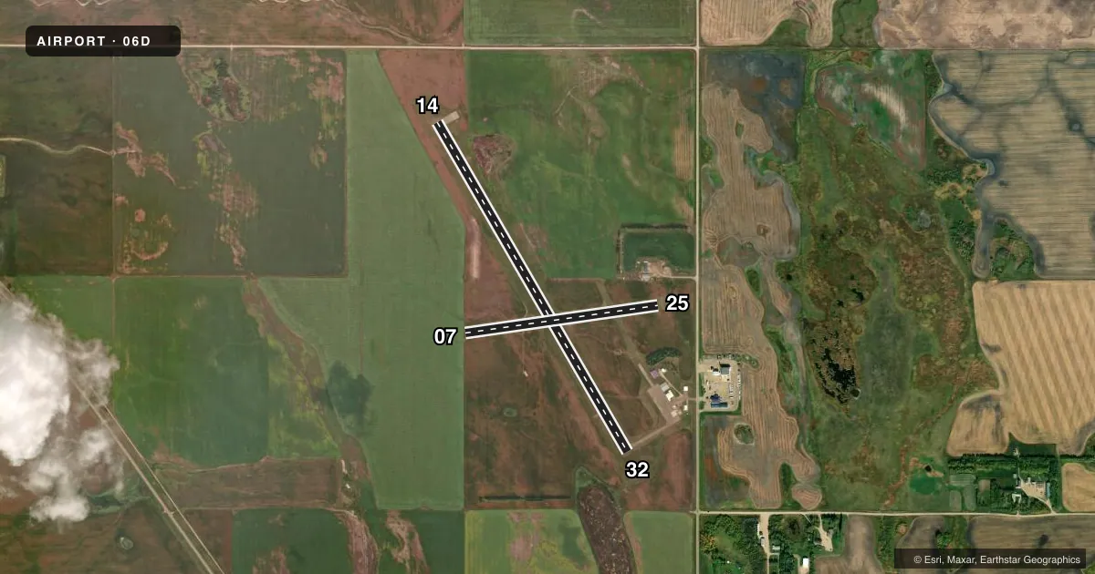
Runways & pattern
Full pagePattern entry · RWY 07
LEFT TRAFFIC| Runway | Heading (°M) | Length | Surface | Traffic |
|---|---|---|---|---|
| 14/32 | 145° / 325° | 4,300 ft | ASPH | Standard L |
| 07/25Favored | 77° / 257° | 2,200 ft | TURF | Standard L |
Runway end performance
| End | TORA | TODA | ASDA | LDA | VGSI | Approach lights | Obstruction |
|---|---|---|---|---|---|---|---|
| 14 | — | — | — | — | PAPI 2-box left(3°) | — | — |
| 32 | — | — | — | — | PAPI 2-box left(3°) | — | — |
Declared distances in feet. TORA = takeoff run available, TODA = takeoff distance, ASDA = accelerate-stop, LDA = landing distance.
Airport sketch
Runways drawn to scale from FAA survey coordinates, rendered over satellite imagery. Not for navigation.
Approaches & charts
Services on the field
Fuel grades, oxygen, maintenance, ramp storage and lighting — as declared to the FAA by the airport operator.
Fuel & services
- Fuel
- 100LLA
- Oxygen (bottled)
- Not available
- Oxygen (bulk)
- Not available
- Airframe repair
- Not available
- Power plant repair
- Not available
- Other services
- AGRI
Ramp & ground
- Transient storage
- Tie-down
- Hangar
- Landing fee
- No fee published
- Customs
- Not available
- Lighting schedule
- SEE RMK
- Beacon schedule
- SS-SR
- Beacon
- White / Green (civil land)(WG)
- Wind indicator
- Lighted
- Segmented circle
- No
Fuel & FBOs
Cheapest 100LL and Jet A on the field and nearby. Always confirm with the FBO before taxi.
Airport notes
Surface conditions, obstructions, local procedures, lighting outages and other notes published with each FAA cycle.
General notes
- FOR SNOW REMOVAL & ARPT CONDS CALL AMGR 701-550-9884, 701-550-0134 OR 701-550-9885.
- RY 07/25 CLSD WINTER MONTHS (OCT-APR) DUE TO LACK OF SNOW REMOVAL.
- WATERFOWL & BIRDS ON & INVOF AIRPORT.
- FOR AWOS CALL 701-477-0055.
- FOR CD IF UNA TO CTC ON FSS FREQ, CTC MINNEAPOLIS ARTCC AT 651-463-5588.
Lighting notes
- ACTVT MIRL RY 14/32 & PAPI RYS 14 & 32 - CTAF.
Fuel notes
- 100LL24 HOUR SELF SERVICE CREDIT CARD FUEL AVBL.
Other notes
- EXISTED PRIOR TO 1959.
- 1FOR ATTENDANT CALL 701-550-9884 OR 701-550-0134.
- MANAGERADDNL PHONE CELL PHONE 701-550-0134 OR AL KRECH 701-550-9885.
VFR map & nearby airports
VFR sectional. Tap any ICAO chip to open that airport.
Key facts · 06D
Answer card- ICAO
- 06D
- Name
- ROLLA MUNI/LEONARD KRECH FLD
- Location
- ROLLA, NORTH DAKOTA
- Elevation
- 1,822.6 ft MSL
- Traffic pattern altitude
- 2,822.6 ft MSL (1,000 AGL)
- Control tower
- Non-towered (use CTAF)
- Total runways
- 2
- Longest runway
- 14/32 · 4,300 ft
- Published ILS approaches
- 0
- Published frequencies
- 2
- Magnetic variation
- 5°
- Current flight rules
- VFR
- Current wind
- 030° at 9 kt
- Favored runway now
- RWY 07
Rolla Muni/Leonard Krech Fld sits in Rolla, North Dakota. Field elevation is 1,822.6 ft MSL. The airport has two runways. The longest is 14/32 at 4,300 ft. Runway 07/25 is 2,200 ft turf. This is an unattended field with no control tower. CTAF and UNICOM are both 122.8.
No ILS approaches are published here. Pattern altitude is not published, so use the standard 1,000 ft AGL for light piston operations unless the current FAA Chart Supplement says otherwise. That puts the traffic pattern at about 2,822.6 ft MSL based on the listed field elevation. Runway 14/32 has medium intensity lights. PAPI is installed on runways 14 and 32. Runway 07/25 is closed during winter months from October through April because there is no snow removal.
Rolla Flying Service is on the field. It carries 100LL and Jet A Prist. Self-serve 100LL is available 24 hours by credit card. The airport remarks also note birds and waterfowl in the area. That matters on arrival and departure. If you need airport conditions or snow removal status, call the airport manager before you go. For clearance delivery if you cannot reach Flight Service, Minneapolis ARTCC is the listed backup contact.