METAR & TAF D55
Current METAR
Observed 22:15Z
KD55 272215Z AUTO 01010KT 10SM CLR 28/25 A2987 RMK AO2
- Wind
- 010° @ 10 kt
- Visibility
- 10 SM
- Temp / Dew
- 28°C / 25°C
- Altimeter
- 29.87 inHg
- Clouds
- CLR
- Density alt
- 3,616 ft
- Ceiling
- Unlimited
- Rules
- VFR
Airport info & contacts
Manager on record, flight service, ARTCC, attendance schedule and pattern altitude — published by the FAA and refreshed every 28 days.
Location
- From city
- 1 NM WSW
- VFR sectional
- TWIN CITIES
- ARTCC
- ZMP · MINNEAPOLIS
- NOTAM facility
- GFK (NOTAM-D)
Airport manager
- Name
- RYAN HOWATT
- Phone
- (701) 370-9710
- Address
- 1228 15TH AVE, LANGDON ND 58249
Flight service · Hours
- FSS GFK
- GRAND FORKS1-800-WX-BRIEF
- Attendance
- ON CALL
Frequencies
Tap any row to copy the frequency to your clipboard.
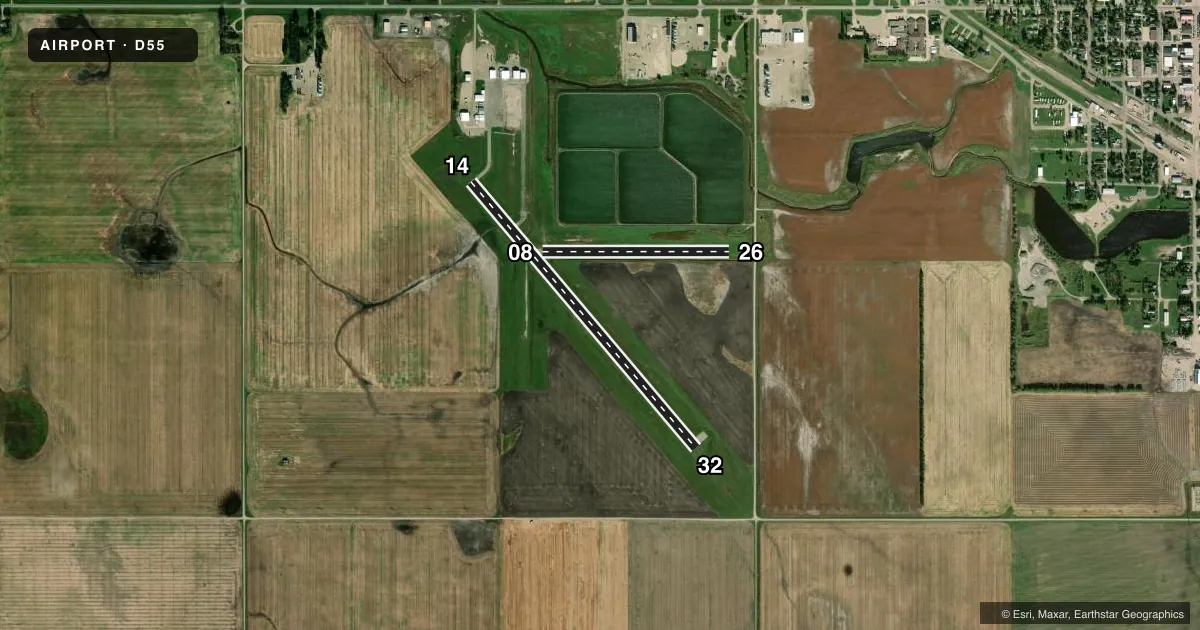
Runways & pattern
Full pagePattern entry · RWY 32
LEFT TRAFFIC| Runway | Heading (°M) | Length | Surface | Traffic |
|---|---|---|---|---|
| 14/32Favored | 132° / 312° | 3,600 ft | ASPH | Standard L |
| 08/26 | 82° / 262° | 1,930 ft | TURF | Standard L |
Runway end performance
| End | TORA | TODA | ASDA | LDA | VGSI | Approach lights | Obstruction |
|---|---|---|---|---|---|---|---|
| 14 | — | — | — | — | PAPI 2-box left(3°) | — | — |
| 32 | — | — | — | — | PAPI 2-box left(3°) | — | — |
| 26 | — | — | — | — | — | — | 14', road, 265' from thr, 0' R of cntrln, slope 18 |
Declared distances in feet. TORA = takeoff run available, TODA = takeoff distance, ASDA = accelerate-stop, LDA = landing distance.
Airport sketch
Runways drawn to scale from FAA survey coordinates, rendered over satellite imagery. Not for navigation.
Approaches & charts
Services on the field
Fuel grades, oxygen, maintenance, ramp storage and lighting — as declared to the FAA by the airport operator.
Fuel & services
- Fuel
- 100LL
- Oxygen (bottled)
- Not available
- Oxygen (bulk)
- Not available
- Airframe repair
- Not available
- Power plant repair
- Not available
- Other services
- AGRI
Ramp & ground
- Transient storage
- Tie-down
- Hangar
- Landing fee
- No fee published
- Customs
- Not available
- Lighting schedule
- SEE RMK
- Beacon schedule
- SS-SR
- Beacon
- White / Green (civil land)(WG)
- Wind indicator
- Lighted
- Segmented circle
- No
Fuel & FBOs
Cheapest 100LL and Jet A on the field and nearby. Always confirm with the FBO before taxi.
Airport notes
Surface conditions, obstructions, local procedures, lighting outages and other notes published with each FAA cycle.
General notes
- RY 08/26 CLOSED WINTERS DUE TO LACK OF SNOW REMOVAL.
- LARGE BIRDS AND DEER ON & INVOF ARPT APR-NOV.
- CFM WINTER CONDS/SNOW REMOVAL WITH AMGR 701-370-9710.
- NOISE SENSITIVE AREA NW QUADRANT OF FIELD; AVOID OVERFLIGHT.
- FOR CD CTC MINNEAPOLIS ARTCC AT 651-463-5588.
- COLD TEMPERATURE AIRPORT. ALTITUDE CORRECTION REQUIRED AT OR BELOW -35C.
Lighting notes
- ACTVT PAPI RWY 14 & 32; MIRL RWY 14/32 - CTAF.
Fuel notes
- 100LLSELF SVC FUEL AVBL 24 HR WITH CREDIT CARD.
Approach & departure obstructions
- 26+334 FT TWR 6550 FT FM THLD, 230 FT R OF EXTDD CNTRLN.
Other notes
- 1FOR SVCS AFT HRS CTC AMGR 701-370-9710.
- OWNERJOHN BOE, CHAIRMAN OF ARPT AUTH, ADDNL PHONE 701-370-2076.
VFR map & nearby airports
VFR sectional. Tap any ICAO chip to open that airport.
Key facts · D55
Answer card- ICAO
- D55
- Name
- ROBERTSON FLD
- Location
- LANGDON, NORTH DAKOTA
- Elevation
- 1,608.4 ft MSL
- Traffic pattern altitude
- 2,608.4 ft MSL (1,000 AGL)
- Control tower
- Non-towered (use CTAF)
- Total runways
- 2
- Longest runway
- 14/32 · 3,600 ft
- Published ILS approaches
- 0
- Published frequencies
- 2
- Magnetic variation
- 7°
- Current flight rules
- VFR
- Current wind
- 010° at 10 kt
- Favored runway now
- RWY 32
Robertson Fld sits in Langdon, North Dakota. The field elevation is 1,608.4 ft MSL. It has two runways. The longest is 14/32 at 3,600 ft asphalt. Runway 08/26 is 1,930 ft turf. There is no control tower. CTAF and UNICOM are both 122.8.
No ILS approaches are published here. The pattern altitude is not published in the facts, so use standard light piston pattern practice unless the current FAA Chart Supplement says otherwise. The field has PAPI on 14 and 32. Medium intensity runway lights are also on 14 and 32. They are controlled by CTAF.
There are no on-field FBOs listed. Self-serve 100LL is available 24 hours with credit card. For after-hours service, contact the airport manager. The published remarks also flag a noise sensitive area in the northwest quadrant. Avoid overflight there. Runway 08/26 is closed in winter because snow removal is not provided. There is also a 334 ft tower near the extended centerline for runway 26. Large birds and deer can be present from April through November. This is a cold temperature airport. Use altitude correction at or below minus 35 degrees Celsius. For clearance delivery, contact Minneapolis ARTCC.