METAR & TAF 5L0
5L0 does not publish a METAR.
Showing the nearest reporting station: KDVL (DEVILS LAKE RGNL) · 24.0 NM away. Conditions at 5L0 may differ.
METAR · KDVL
Observed 17:56Z
KDVL 271756Z AUTO 02010KT 10SM CLR 27/21 A2987 RMK AO2 SLP112 T02670211 10272 20194 50002
- Wind
- 020° @ 10 kt
- Visibility
- 10 SM
- Temp / Dew
- 27°C / 21°C
- Altimeter
- 29.87 inHg
- Clouds
- CLR
- Density alt
- 3,376 ft
- Ceiling
- Unlimited
- Rules
- VFR
Airport info & contacts
Manager on record, flight service, ARTCC, attendance schedule and pattern altitude — published by the FAA and refreshed every 28 days.
Location
- From city
- 1 NM SE
- VFR sectional
- TWIN CITIES
- ARTCC
- ZMP · MINNEAPOLIS
- NOTAM facility
- GFK (NOTAM-D)
Airport manager
- Name
- MATT NELSON
- Phone
- 713-320-4770
- Address
- BOX 505, LAKOTA ND 58344
Flight service · Hours
- FSS GFK
- GRAND FORKS1-800-WX-BRIEF
- Attendance
- Unattended
Frequencies
Tap any row to copy the frequency to your clipboard.
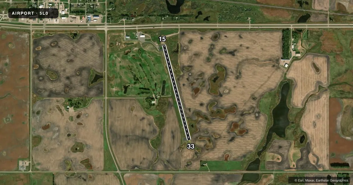
Runways & pattern
Full pagePattern entry · RWY 33
LEFT TRAFFICRunway end performance
| End | TORA | TODA | ASDA | LDA | VGSI | Approach lights | Obstruction |
|---|---|---|---|---|---|---|---|
| 15 | — | — | — | — | PAPI 2-box left(3°) | — | — |
| 33 | — | — | — | — | PAPI 2-box left(3°) | — | — |
Declared distances in feet. TORA = takeoff run available, TODA = takeoff distance, ASDA = accelerate-stop, LDA = landing distance.
Airport sketch
Runways drawn to scale from FAA survey coordinates, rendered over satellite imagery. Not for navigation.
Approaches & charts
Services on the field
Fuel grades, oxygen, maintenance, ramp storage and lighting — as declared to the FAA by the airport operator.
Fuel & services
- Fuel
- 100LL
- Oxygen (bottled)
- Not available
- Oxygen (bulk)
- Not available
- Airframe repair
- Not available
- Power plant repair
- Not available
- Other services
- AGRI
Ramp & ground
- Transient storage
- Tie-down
- Hangar
- Landing fee
- No fee published
- Customs
- Not available
- Lighting schedule
- SEE RMK
- Wind indicator
- Lighted
- Segmented circle
- Yes
Fuel & FBOs
Cheapest 100LL and Jet A on the field and nearby. Always confirm with the FBO before taxi.
Airport notes
Surface conditions, obstructions, local procedures, lighting outages and other notes published with each FAA cycle.
General notes
- CONFIRM SNOW REMOVAL & WINTER COND WITH CITY SUPT 701-304-0127/247-3112.
- 32 FT PLINE MARKED WITH ORANGE BALLS 1/2 NM FROM RWY 33 THLD ON CTRLN.
- FOR CD CTC MINNEAPOLIS ARTCC AT 651-463-5588.
- BIRDS ON & INVOF ARPT.
Lighting notes
- RY 15/33 MIRL AND PAPI OPER DUSK -0000 AFT HRS CTAF 122.8 TO ACTVT.
Fuel notes
- 100LLSELF SVC FUEL AVBL H24 VIA CREDIT CARD.
Approach & departure obstructions
- 15RWY MKGS FADED & WORN.
- 33RWY MKGS FADED & WORN.
- 15+40 FT TREE ROW 1040 FT FM THR 200 FT L AND R OF CNTRLN EXTDD APCH RATIO 20:1.
Other notes
- PRVDD RWY 15 THLD IS DSPLCD TO PRVD A CLEAR APCH OVR THE ROAD TO THE NORTH.
- OWNERCHAIRMAN OF ARPT AUTH; DOUG MANBECK 701-247-2400.
VFR map & nearby airports
VFR sectional. Tap any ICAO chip to open that airport.
Key facts · 5L0
Answer card- ICAO
- 5L0
- Name
- LAKOTA MUNI
- Location
- LAKOTA, NORTH DAKOTA
- Elevation
- 1,511.3 ft MSL
- Traffic pattern altitude
- 2,511.3 ft MSL (1,000 AGL)
- Control tower
- Non-towered (use CTAF)
- Total runways
- 1
- Longest runway
- 15/33 · 3,500 ft
- Published ILS approaches
- 0
- Published frequencies
- 2
- Magnetic variation
- 4°
- Current flight rules
- VFR
- Current wind
- 020° at 10 kt
- Favored runway now
- RWY 33
Lakota Muni sits in Lakota, North Dakota. Field elevation is 1,511.3 ft MSL. The airport has one runway. Runway 15/33 is 3,500 ft of asphalt, so plan performance with that length in mind. There is no control tower. CTAF and UNICOM are both 122.8. No ILS approaches are published here.
Pattern altitude is not published. For light piston traffic, use the standard 1,000 ft AGL pattern unless the current Chart Supplement says otherwise. That puts the traffic pattern at about 2,511.3 ft MSL based on the field elevation. Runway 15/33 has medium intensity lighting and PAPI. The lights operate from dusk to 0000 hours. After hours, use CTAF 122.8 to activate them. Self-service 100LL is available 24 hours by credit card.
A few operational items matter here. There is a 32-foot power line marked with orange balls about one-half nautical mile from the runway 33 threshold on the centerline. Runway 15 has a displaced threshold for a clear approach over the road to the north. A tree row also sits near the runway 15 approach path. Runway markings are faded and worn on both ends. Birds are reported on and near the airport. If you need clearance delivery, contact Minneapolis ARTCC. For snow removal and winter conditions, call the city superintendent before you go.