METAR & TAF 4V4
4V4 does not publish a METAR.
Showing the nearest reporting station: KGFK (GRAND FORKS INTL) · 21.4 NM away. Conditions at 4V4 may differ.
METAR · KGFK
Observed 16:53Z
KGFK 271653Z 32011KT 9SM BKN026 29/22 A2979 RMK AO2 SLP082 FU ALOFT T02940217 $
- Wind
- 320° @ 11 kt
- Visibility
- 9 SM
- Temp / Dew
- 29°C / 22°C
- Altimeter
- 29.79 inHg
- Clouds
- BKN
- Density alt
- 3,229 ft
- Ceiling
- 2,600 ft AGL
- Rules
- MVFR
Airport info & contacts
Manager on record, flight service, ARTCC, attendance schedule and pattern altitude — published by the FAA and refreshed every 28 days.
Location
- From city
- 1 NM SW
- VFR sectional
- TWIN CITIES
- ARTCC
- ZMP · MINNEAPOLIS
- NOTAM facility
- GFK (NOTAM-D)
Airport manager
- Name
- RICH ALTENDORF
- Phone
- 701-587-5171
- Address
- BOX 521, NORTHWOOD ND 58267
Flight service · Hours
- FSS GFK
- GRAND FORKS1-800-WX-BRIEF
- Attendance
- MON-SAT · 0800-1700
Frequencies
Tap any row to copy the frequency to your clipboard.
Runways & pattern
Full pagePattern entry · RWY 26
LEFT TRAFFICRunway end performance
| End | TORA | TODA | ASDA | LDA | VGSI | Approach lights | Obstruction |
|---|---|---|---|---|---|---|---|
| 08 | — | — | — | — | PAPI 2-box left(3°) | — | — |
| 26 | — | — | — | — | PAPI 2-box left(3°) | — | — |
Declared distances in feet. TORA = takeoff run available, TODA = takeoff distance, ASDA = accelerate-stop, LDA = landing distance.
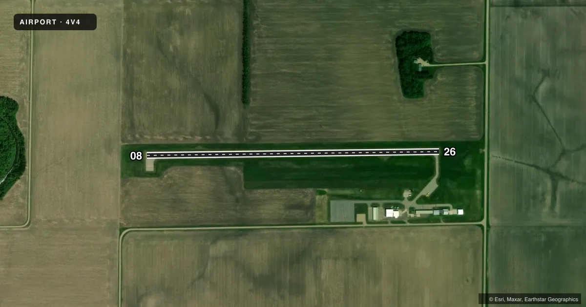
Airport sketch
Runways drawn to scale from FAA survey coordinates, rendered over satellite imagery. Not for navigation.
Approaches & charts
Services on the field
Fuel grades, oxygen, maintenance, ramp storage and lighting — as declared to the FAA by the airport operator.
Fuel & services
- Fuel
- 100LL
- Oxygen (bottled)
- Not available
- Oxygen (bulk)
- Not available
- Airframe repair
- Major
- Power plant repair
- Major
- Other services
- AGRI
Ramp & ground
- Transient storage
- Tie-down
- Hangar
- Landing fee
- No fee published
- Customs
- Not available
- Lighting schedule
- SEE RMK
- Beacon schedule
- SS-SR
- Beacon
- White / Green (civil land)(WG)
- Wind indicator
- Lighted
- Segmented circle
- No
Fuel & FBOs
Cheapest 100LL and Jet A on the field and nearby. Always confirm with the FBO before taxi.
Airport notes
Surface conditions, obstructions, local procedures, lighting outages and other notes published with each FAA cycle.
General notes
- RY 08/26 MAY BE SNOW COVERED DURG WINTER MONTHS. CONFIRM WINTER CONDS WITH AMGR; 701-587-5171/CELL 218-779-1242.
- BIRDS & DEER ON & INVOF ARPT.
- FOR CD CTC MINNEAPOLIS ARTCC AT 651-463-5588.
Lighting notes
- ACTVT PAPI RWY 08 & 26; MIRL RWY 08/26 - CTAF.
Other notes
- 1FOR SVCS AFT HRS CALL AMGR 701-587-5171.
- OWNERCLERK OF ARPT AUTH SHELLY RADKE 701-587-5370.
- MANAGERAMGR HOME PHONE 701-587-6014 OR CELL 218-779-1242
- OWNERCHAIRMAN OF ARPT AUTH RICK MELAND 218-779-6567.
VFR map & nearby airports
VFR sectional. Tap any ICAO chip to open that airport.
Key facts · 4V4
Answer card- ICAO
- 4V4
- Name
- NORTHWOOD MUNI/VINCE FLD
- Location
- NORTHWOOD, NORTH DAKOTA
- Elevation
- 1,118.9 ft MSL
- Traffic pattern altitude
- 2,118.9 ft MSL (1,000 AGL)
- Control tower
- Non-towered (use CTAF)
- Total runways
- 1
- Longest runway
- 08/26 · 3,160 ft
- Published ILS approaches
- 0
- Published frequencies
- 4
- Magnetic variation
- 7°
- Current flight rules
- MVFR
- Current wind
- 320° at 11 kt
- Favored runway now
- RWY 26
Northwood Muni/Vince Fld is in Northwood, North Dakota. The field elevation is 1,118.9 ft MSL. It has one runway, 08/26, which is 3,160 ft long and asphalt. This is an uncontrolled airport. CTAF and UNICOM are both 122.8. No ILS approaches are published here.
Pattern altitude is not published. Use the standard 1,000 ft AGL for light piston traffic unless the current Chart Supplement says otherwise. That puts the pattern at about 2,118.9 ft MSL based on the listed field elevation. Runway lighting is medium intensity on 08/26. The PAPI is available for both runway directions and is activated by the CTAF.
Northwood Aero Service is on the field. It carries AVGAS 100LL. For a first-time arrival, watch for birds and deer in the area. Winter can also bring snow-covered runway conditions on 08/26, so confirm surface conditions before you go. For clearance delivery, the published contact is Minneapolis ARTCC. If you need after-hours service, call the airport manager directly. The airport sits in open country, so plan for normal rural North Dakota weather and be ready to verify current conditions before departure.