METAR & TAF 64G
64G does not publish a METAR.
Showing the nearest reporting station: KBAC (BARNES COUNTY MUNI) · 25.9 NM away. Conditions at 64G may differ.
METAR · KBAC
Observed 07:55Z
KBAC 140755Z AUTO 30006KT 10SM CLR 07/07 A3011 RMK AO2
- Wind
- 300° @ 6 kt
- Visibility
- 10 SM
- Temp / Dew
- 7°C / 7°C
- Altimeter
- 30.11 inHg
- Clouds
- CLR
- Density alt
- 315 ft
- Ceiling
- Unlimited
- Rules
- VFR
Airport info & contacts
Manager on record, flight service, ARTCC, attendance schedule and pattern altitude — published by the FAA and refreshed every 28 days.
Location
- From city
- 4 NM E
- VFR sectional
- TWIN CITIES
- ARTCC
- ZMP · MINNEAPOLIS
- NOTAM facility
- GFK (NOTAM-D)
Airport manager
- Name
- TIM MCPHERSON
- Phone
- 701-668-2302
- Address
- 14269 17TH ST S.E., PAGE ND 58064
Flight service · Hours
- FSS GFK
- GRAND FORKS1-800-WX-BRIEF
- Attendance
- ON CALL
Frequencies
Tap any row to copy the frequency to your clipboard.
Runways & pattern
Full pagePattern entry · RWY 35
LEFT TRAFFICRunway end performance
| End | TORA | TODA | ASDA | LDA | VGSI | Approach lights | Obstruction |
|---|---|---|---|---|---|---|---|
| 17 | — | — | — | — | — | — | 15', other, 390' from thr, 140' R of cntrln, slope 12 |
Declared distances in feet. TORA = takeoff run available, TODA = takeoff distance, ASDA = accelerate-stop, LDA = landing distance.
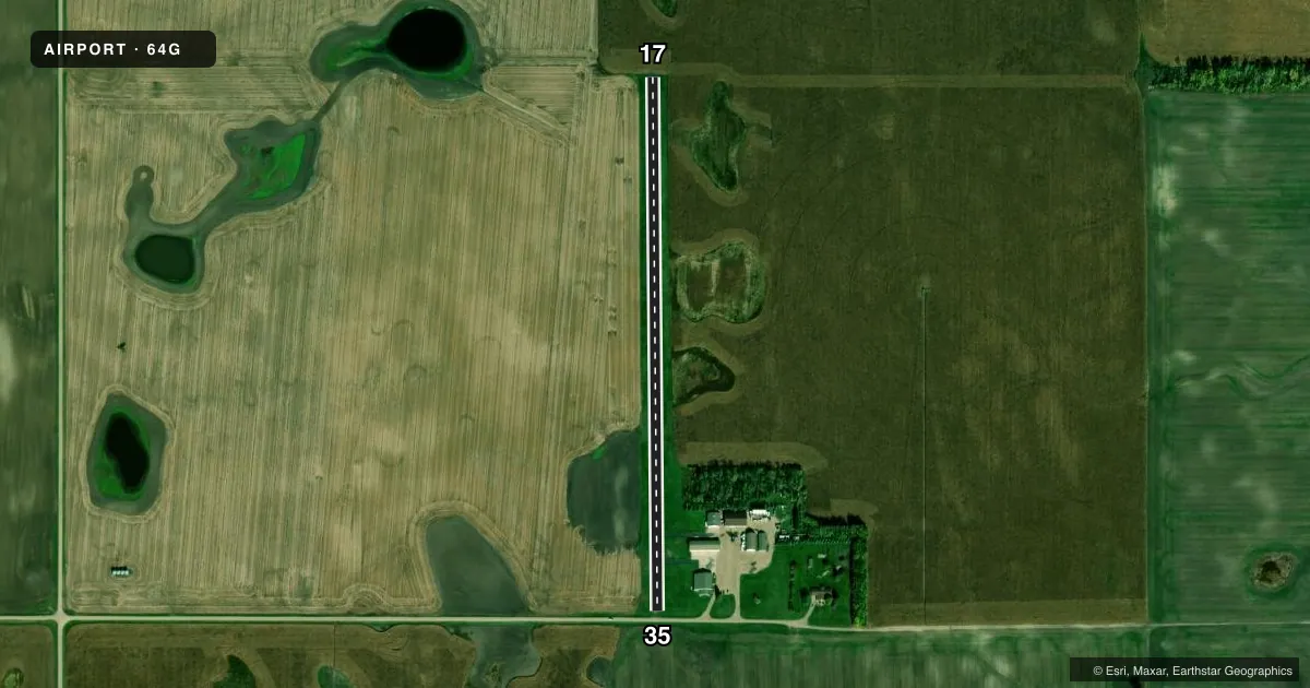
Airport sketch
Runways drawn to scale from FAA survey coordinates, rendered over satellite imagery. Not for navigation.
Approaches & charts
Services on the field
Fuel grades, oxygen, maintenance, ramp storage and lighting — as declared to the FAA by the airport operator.
Fuel & services
- Fuel
- 100LLA
- Airframe repair
- Major
- Power plant repair
- Major
- Other services
- AGRI,INSTR
Ramp & ground
- Transient storage
- Tie-down
- Hangar
- Wind indicator
- Yes
- Segmented circle
- No
Fuel & FBOs
Cheapest 100LL and Jet A on the field and nearby. Always confirm with the FBO before taxi.
Airport notes
Surface conditions, obstructions, local procedures, lighting outages and other notes published with each FAA cycle.
General notes
- RY 17/35 HAS CULTIVATED FIELDS AT BOTH ENDS.
- CONFIRM SNOW REMOVAL AFTER WINTER STORMS WITH AMGR.
- BIRD & DEER ON & INVOF ARPT.
- FOR CD CTC MINNEAPOLIS ARTCC AT 651-463-5588.
Fuel notes
- 100LLFOR FUEL CALL 701-668-2302.
Runway surface & condition
- 17/35RWY 35 END LACKS TURNAROUND
Approach & departure obstructions
- 177 FT CORNFIELD ADJ RWY 17 THR.
- 35RY 35 15 FT RD 40 FT FM THLD.
- 17IRRIGATION PIVOT.
Other notes
- TRAFFIC PATTERN CONFLICT WITH CONRAD & THOMPSON ARPTS. IN ADDITION MAN-MADE OR NATURAL OBJECTS OBSTRUCT.
- PROPERTY LEASED TO PAGE REGIONAL ARPT AUTHORITY.
- 1FOR ARPT SERVICES CALL AMGR AT 701-668-2302.
- MANAGERAMGR HOME PHONE 701-668-2302 OR CELL 701-799-8629
VFR map & nearby airports
VFR sectional. Tap any ICAO chip to open that airport.
Key facts · 64G
Answer card- ICAO
- 64G
- Name
- PAGE RGNL
- Location
- PAGE, NORTH DAKOTA
- Elevation
- 1,218 ft MSL
- Traffic pattern altitude
- 2,218 ft MSL (1,000 AGL)
- Control tower
- Non-towered (use CTAF)
- Total runways
- 1
- Longest runway
- 17/35 · 2,600 ft
- Published ILS approaches
- 0
- Published frequencies
- 1
- Magnetic variation
- 7°
- Current flight rules
- VFR
- Current wind
- 300° at 6 kt
- Favored runway now
- RWY 35
Page Rgnl is in Page, North Dakota. The field elevation is 1,218 ft MSL. It has one runway, 17/35, with a longest length of 2,600 ft on asphalt. There is no control tower. CTAF is 122.9.
No ILS approaches are published here. The pattern altitude is not published, so use the current Chart Supplement and local procedures before you arrive. The published remarks matter here. Runway 17 has a 7-foot cornfield near the touchdown area. There is also an irrigation pivot near the 17 end. Runway 35 has a road about 40 ft from the threshold. The 35 end also lacks a turnaround. The airport sits in cultivated ground at both ends. Birds and deer are reported on and near the field.
There are no on-field FBOs listed. For 100LL fuel or airport services, call the airport manager at 701-668-2302. The airport is leased to the Page Regional Airport Authority. Clearance delivery is handled through Minneapolis ARTCC at 651-463-5588. Pilots should also watch for traffic pattern conflict with Conrad and Thompson Airports. That makes local traffic awareness important on arrival and departure.