METAR & TAF 1A2
1A2 does not publish a METAR.
Showing the nearest reporting station: KFAR (HECTOR INTL) · 19.8 NM away. Conditions at 1A2 may differ.
METAR · KFAR
Observed 22:53Z
KFAR 272253Z 35011KT 10SM FEW060 33/20 A2979 RMK AO2 SLP082 T03280200 $
- Wind
- 350° @ 11 kt
- Visibility
- 10 SM
- Temp / Dew
- 33°C / 20°C
- Altimeter
- 29.79 inHg
- Clouds
- FEW
- Density alt
- 3,528 ft
- Ceiling
- Unlimited
- Rules
- VFR
Airport info & contacts
Manager on record, flight service, ARTCC, attendance schedule and pattern altitude — published by the FAA and refreshed every 28 days.
Location
- From city
- 1 NM NE
- VFR sectional
- TWIN CITIES
- ARTCC
- ZMP · MINNEAPOLIS
- NOTAM facility
- GFK (NOTAM-D)
Airport manager
- Name
- RICK BURGUM
- Phone
- 701-997-6101
- Address
- BOX 145, ARTHUR ND 58006
Flight service · Hours
- FSS GFK
- GRAND FORKS1-800-WX-BRIEF
- Attendance
- Unattended
Frequencies
Tap any row to copy the frequency to your clipboard.
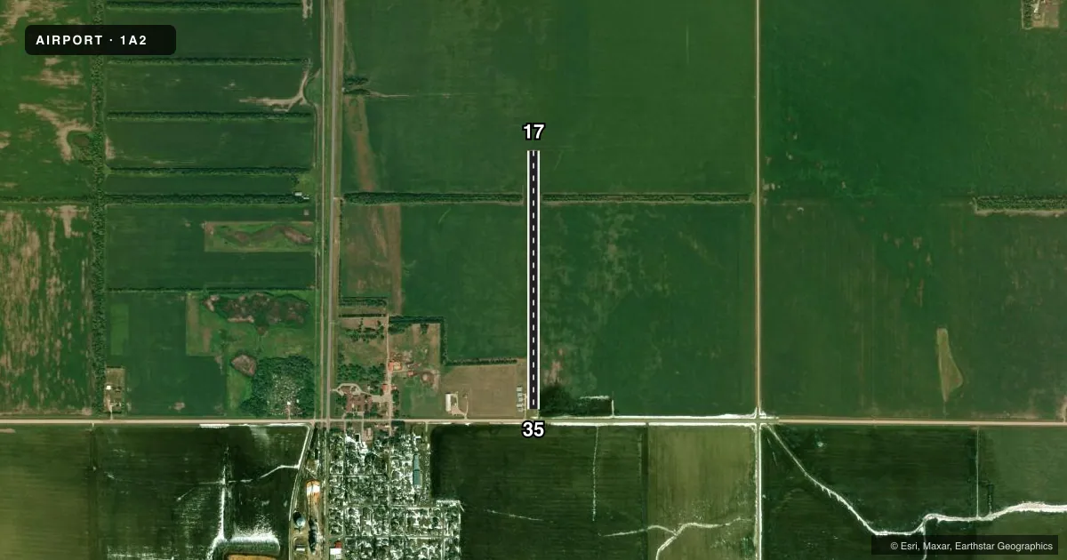
Runways & pattern
Full pagePattern entry · RWY 35
LEFT TRAFFICRunway end performance
| End | TORA | TODA | ASDA | LDA | VGSI | Approach lights | Obstruction |
|---|---|---|---|---|---|---|---|
| 35 | — | — | — | — | — | — | 18', road, 120' from thr, 0' R of cntrln, slope 6 |
Declared distances in feet. TORA = takeoff run available, TODA = takeoff distance, ASDA = accelerate-stop, LDA = landing distance.
Airport sketch
Runways drawn to scale from FAA survey coordinates, rendered over satellite imagery. Not for navigation.
Approaches & charts
Services on the field
Fuel grades, oxygen, maintenance, ramp storage and lighting — as declared to the FAA by the airport operator.
Fuel & services
- Fuel
- Not available
- Oxygen (bottled)
- Not available
- Oxygen (bulk)
- Not available
- Airframe repair
- Not available
- Power plant repair
- Not available
Ramp & ground
- Transient storage
- Not published
- Landing fee
- No fee published
- Wind indicator
- Yes
- Segmented circle
- No
Fuel & FBOs
Cheapest 100LL and Jet A on the field and nearby. Always confirm with the FBO before taxi.
Airport notes
Surface conditions, obstructions, local procedures, lighting outages and other notes published with each FAA cycle.
General notes
- NO SN REMOVAL AVBL; CFM WINTER CONDS PRIOR TO USE CALL 701-997-6101 OR 701-261-0112.
- 50 FT TREES 125 FT L & R OF CNTRLN; 600 FT INBOUND FM RY 17 THLD.
- FOR CD CTC MINNEAPOLIS ARTCC AT 651-463-5588.
- BIRDS & DEER INVOF ARPT.
Other notes
- MANAGERCHAIRMAN ARPT AUTH KEVIN SKUNES - PHONE 701-261-0112.
VFR map & nearby airports
VFR sectional. Tap any ICAO chip to open that airport.
Key facts · 1A2
Answer card- ICAO
- 1A2
- Name
- ARTHUR
- Location
- ARTHUR, NORTH DAKOTA
- Elevation
- 973 ft MSL
- Traffic pattern altitude
- 1,973 ft MSL (1,000 AGL)
- Control tower
- Non-towered (use CTAF)
- Total runways
- 1
- Longest runway
- 17/35 · 3,100 ft
- Published ILS approaches
- 0
- Published frequencies
- 1
- Magnetic variation
- 6°
- Current flight rules
- VFR
- Current wind
- 350° at 11 kt
- Favored runway now
- RWY 35
Arthur Airport (1A2) sits in Arthur, North Dakota. Field elevation is 973 ft MSL. The airport has one runway. Runway 17/35 is 3,100 ft of turf, so plan for soft-field performance and keep the surface condition in mind before you go. There is no control tower. CTAF is 122.9.
No ILS approaches are published here. The pattern altitude is not published, so use the standard 1,000 ft AGL pattern unless current local guidance says otherwise. That puts the traffic pattern at about 1,973 ft MSL based on the field elevation. The published remarks also call out 50-foot trees near runway 17 on both sides of the centerline, about 600 ft from the threshold. Birds and deer are also reported in the area. There is no snow removal available, so winter use needs a careful look at current surface conditions before departure.
There are no on-field FBOs listed. If you need current services or local coordination, contact the airport authority directly. For clearance delivery, Minneapolis ARTCC is the published contact. This is a small non-towered turf field, so a normal self-announce pattern and good lookout discipline matter. Check the current FAA Chart Supplement before flying in if you want the latest operational notes or seasonal restrictions.