METAR & TAF 5N8
5N8 does not publish a METAR.
Showing the nearest reporting station: KFAR (HECTOR INTL) · 16.6 NM away. Conditions at 5N8 may differ.
METAR · KFAR
Observed 22:53Z
KFAR 272253Z 35011KT 10SM FEW060 33/20 A2979 RMK AO2 SLP082 T03280200 $
- Wind
- 350° @ 11 kt
- Visibility
- 10 SM
- Temp / Dew
- 33°C / 20°C
- Altimeter
- 29.79 inHg
- Clouds
- FEW
- Density alt
- 3,478 ft
- Ceiling
- Unlimited
- Rules
- VFR
Airport info & contacts
Manager on record, flight service, ARTCC, attendance schedule and pattern altitude — published by the FAA and refreshed every 28 days.
Location
- From city
- 4 NM S
- VFR sectional
- TWIN CITIES
- ARTCC
- ZMP · MINNEAPOLIS
- NOTAM facility
- GFK (NOTAM-D)
Airport manager
- Name
- MATT HOVDENES
- Phone
- 218-790-2765
- Address
- PO BOX 234, CASSELTON ND 58012
Flight service · Hours
- FSS GFK
- GRAND FORKS1-800-WX-BRIEF
- Attendance
- OCT-MAY · MON-SAT · 0800-1700
- JUN-SEP · MON-SAT · 0800-2200
- SUN · ON CALL
Frequencies
Tap any row to copy the frequency to your clipboard.
Runways & pattern
Full pagePattern entry · RWY 31
LEFT TRAFFICRunway end performance
| End | TORA | TODA | ASDA | LDA | VGSI | Approach lights | Obstruction |
|---|---|---|---|---|---|---|---|
| 13 | — | — | — | — | PAPI 2-box right(3°) | — | — |
| 31 | — | — | — | — | PAPI 2-box left(3°) | — | — |
Declared distances in feet. TORA = takeoff run available, TODA = takeoff distance, ASDA = accelerate-stop, LDA = landing distance.
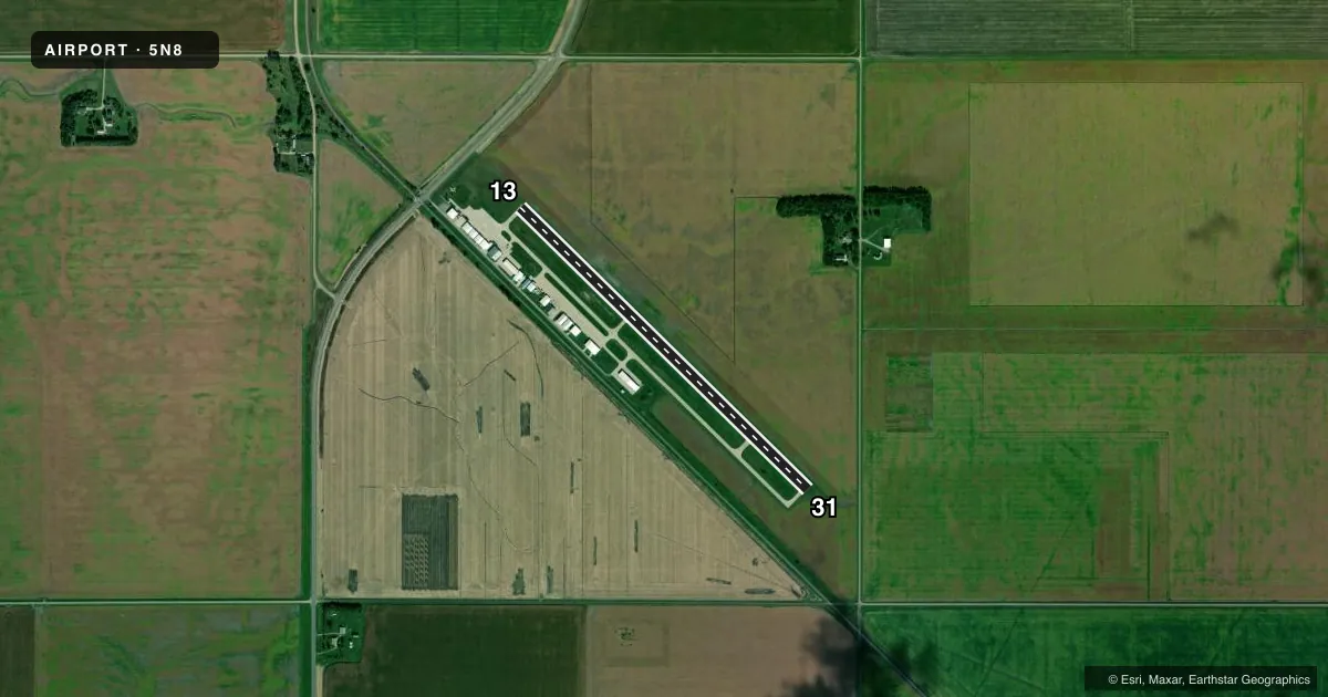
Airport sketch
Runways drawn to scale from FAA survey coordinates, rendered over satellite imagery. Not for navigation.
Approaches & charts
Services on the field
Fuel grades, oxygen, maintenance, ramp storage and lighting — as declared to the FAA by the airport operator.
Fuel & services
- Fuel
- 100LL
- Airframe repair
- Major
- Power plant repair
- Major
- Other services
- AGRI,GLD,INSTR,SALES
Ramp & ground
- Transient storage
- Tie-down
- Lighting schedule
- SEE RMK
- Wind indicator
- Lighted
- Segmented circle
- Yes
Fuel & FBOs
Cheapest 100LL and Jet A on the field and nearby. Always confirm with the FBO before taxi.
Airport notes
Surface conditions, obstructions, local procedures, lighting outages and other notes published with each FAA cycle.
General notes
- CONFIRM WINTER CONDS & SNOW REMOVAL CALL 701-347-4680 BTN 0800-1700.
- NUMEROUS AGRICULTURAL OPNS MAY-OCT.
- ACFT PAINT SHOP AVBL 701-347-5262.
- FOR CD CTC FARGO APCH AT 701-239-5188.
Lighting notes
- ACTVT REIL RWY 31; PAPI RWY 13; MIRL RWY 13/31 - CTAF.
Fuel notes
- 100LLSELF-SCC CREDIT CARD 100LL FUEL AVBL 24 HRS.
Other notes
- 1FOR ARPT ATTENDANCE AFT HRS CALL 701-347-5519/4680.
- MANAGERADNL PHONE 701-799-4606/701-347-5519/701-347-4680/701-799-5782.
VFR map & nearby airports
VFR sectional. Tap any ICAO chip to open that airport.
Key facts · 5N8
Answer card- ICAO
- 5N8
- Name
- CASSELTON ROBERT MILLER RGNL
- Location
- CASSELTON, NORTH DAKOTA
- Elevation
- 933.3 ft MSL
- Traffic pattern altitude
- 1,933.3 ft MSL (1,000 AGL)
- Control tower
- Non-towered (use CTAF)
- Total runways
- 1
- Longest runway
- 13/31 · 3,901 ft
- Published ILS approaches
- 0
- Published frequencies
- 4
- Magnetic variation
- 6°
- Current flight rules
- VFR
- Current wind
- 350° at 11 kt
- Favored runway now
- RWY 31
Casselton Robert Miller Rgnl (5N8) sits in Casselton, North Dakota at 933.3 ft MSL. It has one runway. Runway 13/31 is 3,901 ft of concrete, so plan for a short-field mindset if you are bringing in a heavier airplane. The field is non-towered. CTAF and UNICOM are both 122.8. Fargo Approach handles approach and departure work on 120.4 and 377.15. No ILS approaches are published here.
Pattern altitude is not published. Use 1,000 ft AGL for light piston operations unless the current Chart Supplement says otherwise. The airport carries a magnetic variation of 6°. The on-field FBO is AIC Maintenance. It carries 100LL. Self-serve credit card 100LL is available 24 hours. There is also an aircraft paint shop on the field.
A few operational notes matter here. Runway end identifier lights are on runway 31. Precision approach path indicators are on runway 13. Medium intensity runway lights are on both runway ends. Numerous agricultural operations occur from May through October, so expect local traffic and stay sharp on the CTAF. If you need clearance delivery, Fargo Approach is listed for that. For winter conditions or snow removal status, call ahead before you launch.