METAR & TAF KJKJ
Current METAR
Observed 23:15Z
KJKJ 272315Z AUTO 36008KT 10SM CLR 32/22 A2980 RMK AO2
- Wind
- 360° @ 8 kt
- Visibility
- 10 SM
- Temp / Dew
- 32°C / 22°C
- Altimeter
- 29.80 inHg
- Clouds
- CLR
- Density alt
- 3,327 ft
- Ceiling
- Unlimited
- Rules
- VFR
Airport info & contacts
Manager on record, flight service, ARTCC, attendance schedule and pattern altitude — published by the FAA and refreshed every 28 days.
Location
- From city
- 4 NM SE
- VFR sectional
- TWIN CITIES
- Pattern altitude
- 800 ft AGL · 1,718 ft MSL
- ARTCC
- ZMP · MINNEAPOLIS
- NOTAM facility
- JKJ (NOTAM-D)
Airport manager
- Name
- MATT OVERHOLT
- Phone
- 701-566-2113
- Address
- 3309 70TH ST S, MOORHEAD MN 56547-9607
Flight service · Hours
- FSS PNM
- PRINCETON1-800-WX-BRIEF
- Attendance
- MON-FRI · 0800-1700
Frequencies
Tap any row to copy the frequency to your clipboard.
Runways & pattern
Full pagePattern entry · RWY 30
LEFT TRAFFICRunway end performance
| End | TORA | TODA | ASDA | LDA | VGSI | Approach lights | Obstruction |
|---|---|---|---|---|---|---|---|
| 12 | — | — | — | — | PAPI 4-box left(3°) | — | — |
| 30 | — | — | — | — | PAPI 4-box left(3°) | — | — |
Declared distances in feet. TORA = takeoff run available, TODA = takeoff distance, ASDA = accelerate-stop, LDA = landing distance.
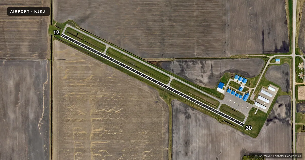
Airport sketch
Runways drawn to scale from FAA survey coordinates, rendered over satellite imagery. Not for navigation.
Approaches & charts
Services on the field
Fuel grades, oxygen, maintenance, ramp storage and lighting — as declared to the FAA by the airport operator.
Fuel & services
- Fuel
- 100LLA
- Oxygen (bottled)
- Not available
- Oxygen (bulk)
- HIGH/LOW
- Airframe repair
- Major
- Power plant repair
- Major
- Other services
- AVNCS,RNTL,SALES
Ramp & ground
- Transient storage
- Tie-down
- Hangar
- Lighting schedule
- SEE RMK
- Beacon schedule
- SS-SR
- Beacon
- White / Green (civil land)(WG)
- Wind indicator
- Lighted
- Segmented circle
- No
Fuel & FBOs
Cheapest 100LL and Jet A on the field and nearby. Always confirm with the FBO before taxi.
Airport notes
Surface conditions, obstructions, local procedures, lighting outages and other notes published with each FAA cycle.
General notes
- ARPT UNDERLIES FARGO TRSA; HECTOR INTL CLASS D AIRSPACE 3 MILES NW OF ARPT.
- NOISE ABATEMENT PROCS IN EFCT, CTC AMGR FOR DTLS.
- GCO AVBL ON FREQ 121.725.
- FOR CD CTC FARGO APCH AT 701-239-5188.
Lighting notes
- ACTVT REIL RWY 12 & 30; PAPI RWY 12 & 30; MIRL RWY 12/30 - CTAF.
Fuel notes
- 100LLFUEL AVBL H24 SELF SVC VIA CREDIT CARD.
Other notes
- FOUR PRIVATE ARPTS WILL CLOSE; OWNER WILL COORDINATE WITH FARGO ATCT; FUTURE ALP REVISIONS WILL BE COORDINATED WITH FARGO ATM; ALL TFC PATTERNS WILL NOT CONFLICT WITH HECTOR INTL ARPT.
- 1FOR SVC AFT HRS CALL AMGR.
- MANAGERCELL 701-866-1495.
VFR map & nearby airports
VFR sectional. Tap any ICAO chip to open that airport.
Key facts · KJKJ
Answer card- ICAO
- KJKJ
- Name
- MOORHEAD MUNI/FLORENCE KLINGENSMITH FLD
- Location
- MOORHEAD, MINNESOTA
- Elevation
- 918.1 ft MSL
- Traffic pattern altitude
- 1,718.1 ft MSL (800 AGL)
- Control tower
- Non-towered (use CTAF)
- Total runways
- 1
- Longest runway
- 12/30 · 4,300 ft
- Published ILS approaches
- 0
- Published frequencies
- 4
- Magnetic variation
- 3°
- Current flight rules
- VFR
- Current wind
- 360° at 8 kt
- Favored runway now
- RWY 30
Moorhead Muni / Florence Klingensmith Fld sits in Moorhead, Minnesota. The field elevation is 918.1 ft MSL. It has one runway, 12/30, which is 4,300 ft long. There is no control tower. Pattern altitude is 800 ft AGL, which is 1,718.1 ft MSL.
No ILS approaches are published here. The airport lies under the Fargo Terminal Radar Service Area. Hector International Class D airspace is 3 miles northwest of the airport. Plan on talking to Fargo Approach for clearance delivery if you need it. The published remarks also note noise abatement procedures. Check the current FAA Chart Supplement or call the airport manager for the details before you go.
Runway lighting is straightforward for night work. Runway end identifier lights are active on 12 and 30. Precision approach path indicators are installed on both ends. Medium intensity runway lights are on runway 12/30. Moorhead Aviation is the on-field FBO. It carries 100LL and Jet A. 100LL is also available 24 hours a day self-serve by credit card. For a first-time arrival, the main things to watch are the TRSA environment, the nearby Class D airspace and local noise procedures. This is a good field to brief before you launch.