METAR & TAF 04Y
04Y does not publish a METAR.
Showing the nearest reporting station: KJKJ (MOORHEAD MUNI/FLORENCE KLINGENSMITH FLD) · 13.1 NM away. Conditions at 04Y may differ.
METAR · KJKJ
Observed 10:55Z
KJKJ 271055Z AUTO 32008KT 10SM CLR 21/17 A2975 RMK AO2
- Wind
- 320° @ 8 kt
- Visibility
- 10 SM
- Temp / Dew
- 21°C / 17°C
- Altimeter
- 29.75 inHg
- Clouds
- CLR
- Density alt
- 2,431 ft
- Ceiling
- Unlimited
- Rules
- VFR
Airport info & contacts
Manager on record, flight service, ARTCC, attendance schedule and pattern altitude — published by the FAA and refreshed every 28 days.
Location
- From city
- 2 NM W
- VFR sectional
- TWIN CITIES
- ARTCC
- ZMP · MINNEAPOLIS
- NOTAM facility
- PNM (NOTAM-D)
Airport manager
- Name
- ERICA POLLEY
- Phone
- 218-483-3331
- Address
- PO BOX 69, HAWLEY MN 56549-0069
Flight service · Hours
- FSS PNM
- PRINCETON1-800-WX-BRIEF
- Attendance
- Unattended
Frequencies
Tap any row to copy the frequency to your clipboard.
Runways & pattern
Full pagePattern entry · RWY 34
LEFT TRAFFICRunway end performance
| End | TORA | TODA | ASDA | LDA | VGSI | Approach lights | Obstruction |
|---|---|---|---|---|---|---|---|
| 16 | — | — | — | — | PAPI 2-box left(3°) | — | — |
| 34 | — | — | — | — | PAPI 2-box left(3°) | — | — |
Declared distances in feet. TORA = takeoff run available, TODA = takeoff distance, ASDA = accelerate-stop, LDA = landing distance.
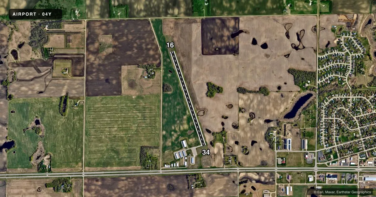
Airport sketch
Runways drawn to scale from FAA survey coordinates, rendered over satellite imagery. Not for navigation.
Approaches & charts
Services on the field
Fuel grades, oxygen, maintenance, ramp storage and lighting — as declared to the FAA by the airport operator.
Fuel & services
- Fuel
- 100LL
- Oxygen (bottled)
- Not available
- Oxygen (bulk)
- Not available
- Airframe repair
- Not available
- Power plant repair
- Not available
Ramp & ground
- Transient storage
- Tie-down
- Landing fee
- No fee published
- Customs
- Not available
- Lighting schedule
- SEE RMK
- Beacon schedule
- SS-SR
- Beacon
- White / Green (civil land)(WG)
- Wind indicator
- Lighted
- Segmented circle
- No
Fuel & FBOs
Cheapest 100LL and Jet A on the field and nearby. Always confirm with the FBO before taxi.
Airport notes
Surface conditions, obstructions, local procedures, lighting outages and other notes published with each FAA cycle.
General notes
- ULTRALIGHTS ON & INVOF ARPT.
- FOR CD CTC FARGO APCH AT 701-239-5188.
Lighting notes
- ACTVT PAPI RWY 16 & 34; MIRL RWY 16/34 - CTAF.
Fuel notes
- 100LLFUEL AVBL H24 VIA CREDIT CARD.
VFR map & nearby airports
VFR sectional. Tap any ICAO chip to open that airport.
Key facts · 04Y
Answer card- ICAO
- 04Y
- Name
- HAWLEY MUNI
- Location
- HAWLEY, MINNESOTA
- Elevation
- 1,209.7 ft MSL
- Traffic pattern altitude
- 2,209.7 ft MSL (1,000 AGL)
- Control tower
- Non-towered (use CTAF)
- Total runways
- 1
- Longest runway
- 16/34 · 3,398 ft
- Published ILS approaches
- 0
- Published frequencies
- 4
- Magnetic variation
- 5°
- Current flight rules
- VFR
- Current wind
- 320° at 8 kt
- Favored runway now
- RWY 34
Hawley Muni sits in Hawley, Minnesota. The field elevation is 1,209.7 ft MSL. It has one runway, 16/34, which is 3,398 ft long and paved with asphalt. There is no control tower. The pattern altitude is not published, so use the standard 1,000 ft AGL for light piston operations unless the current Chart Supplement says otherwise.
No ILS approaches are published here. For clearance delivery, contact Fargo Approach at 701-239-5188. The published frequencies include CTAF and UNICOM on 122.8. Fargo approach and departure are on 120.4 and 377.15. The airport also has PAPI on runways 16 and 34. Medium intensity runway lights are activated for both ends on the CTAF.
Hawley Municipal Airport is the on-field FBO. It carries 100LL. Fuel is available 24 hours a day by credit card. Ultralights are on and in the vicinity of the airport, so keep a sharp scan in the pattern and on taxi. For a first visit, plan for an uncontrolled field with a modest runway length. Winter weather can matter in this part of Minnesota. Standard non-towered traffic discipline applies. If you need anything beyond these published details, check the current FAA Chart Supplement or call the airport operator directly.