METAR & TAF 3N8
Current METAR
Observed 17:15Z
K3N8 271715Z AUTO 01009KT 10SM CLR 29/21 A2981 RMK AO2 T02850210
- Wind
- 010° @ 9 kt
- Visibility
- 10 SM
- Temp / Dew
- 29°C / 21°C
- Altimeter
- 29.81 inHg
- Clouds
- CLR
- Density alt
- 3,361 ft
- Ceiling
- Unlimited
- Rules
- VFR
Airport info & contacts
Manager on record, flight service, ARTCC, attendance schedule and pattern altitude — published by the FAA and refreshed every 28 days.
Location
- From city
- 3 NM SSE
- VFR sectional
- TWIN CITIES
- ARTCC
- ZMP · MINNEAPOLIS
- NOTAM facility
- PNM (NOTAM-D)
Airport manager
- Name
- BILL NELSON
- Phone
- 218-280-1585
- Address
- PO BOX 379, MAHNOMEN MN 56557-0379
Flight service · Hours
- FSS PNM
- PRINCETON1-800-WX-BRIEF
- Attendance
- Unattended
Frequencies
Tap any row to copy the frequency to your clipboard.
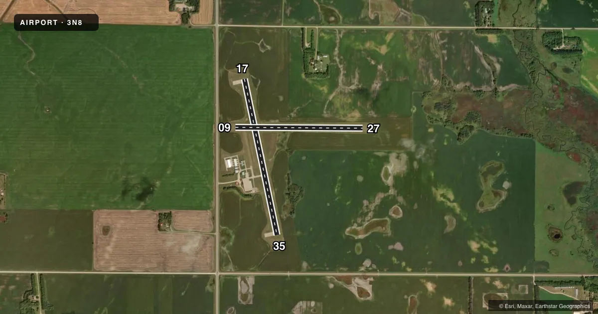
Runways & pattern
Full pagePattern entry · RWY 35
LEFT TRAFFIC| Runway | Heading (°M) | Length | Surface | Traffic |
|---|---|---|---|---|
| 17/35Favored | 166° / 346° | 3,400 ft | ASPH | Standard L |
| 09/27 | 88° / 268° | 2,720 ft | TURF | Standard L |
Runway end performance
| End | TORA | TODA | ASDA | LDA | VGSI | Approach lights | Obstruction |
|---|---|---|---|---|---|---|---|
| 17 | — | — | — | — | PAPI 2-box left(3°) | — | — |
| 35 | — | — | — | — | PAPI 2-box left(3°) | — | — |
Declared distances in feet. TORA = takeoff run available, TODA = takeoff distance, ASDA = accelerate-stop, LDA = landing distance.
Airport sketch
Runways drawn to scale from FAA survey coordinates, rendered over satellite imagery. Not for navigation.
Approaches & charts
Services on the field
Fuel grades, oxygen, maintenance, ramp storage and lighting — as declared to the FAA by the airport operator.
Fuel & services
- Fuel
- 100LL
- Oxygen (bottled)
- Not available
- Oxygen (bulk)
- Not available
- Airframe repair
- Not available
- Power plant repair
- Not available
Ramp & ground
- Transient storage
- Tie-down
- Landing fee
- No fee published
- Lighting schedule
- SEE RMK
- Beacon schedule
- SS-SR
- Beacon
- White / Green (civil land)(WG)
- Wind indicator
- Lighted
- Segmented circle
- No
Fuel & FBOs
Cheapest 100LL and Jet A on the field and nearby. Always confirm with the FBO before taxi.
Airport notes
Surface conditions, obstructions, local procedures, lighting outages and other notes published with each FAA cycle.
General notes
- ULTRALIGHT TFC ON & INVOF ARPT.
- FOR CD CTC MINNEAPOLIS ARTCC AT 651-463-5588.
Lighting notes
- ACTVT OR INCR INTST REIL RWY 17 & 35; PAPI RWY 17 & 35; MIRL RWY 17/35 - CTAF. MIRL RWY 17/35 PRESET LOW INTST.
Fuel notes
- 100LLFUEL AVBL H24 SELF SER VIA CREDIT CARD.
Runway surface & condition
- 09/27NOT PLOWED DRG WINTER MONTHS.
Approach & departure obstructions
- 09MKD WITH YELLOW CONES.
- 27MKD WITH YELLOW CONES.
Other notes
- MANAGERCTC SHERIFF 218-935-2563 OR AMGR CELL 218-280-1585.
VFR map & nearby airports
VFR sectional. Tap any ICAO chip to open that airport.
Key facts · 3N8
Answer card- ICAO
- 3N8
- Name
- MAHNOMEN COUNTY
- Location
- MAHNOMEN, MINNESOTA
- Elevation
- 1,245.5 ft MSL
- Traffic pattern altitude
- 2,245.5 ft MSL (1,000 AGL)
- Control tower
- Non-towered (use CTAF)
- Total runways
- 2
- Longest runway
- 17/35 · 3,400 ft
- Published ILS approaches
- 0
- Published frequencies
- 1
- Magnetic variation
- 2°
- Current flight rules
- VFR
- Current wind
- 010° at 9 kt
- Favored runway now
- RWY 35
Mahnomen County Airport (3N8) sits in Mahnomen, Minnesota. Field elevation is 1,245.5 ft MSL. The airport has two runways. The longest is 17/35 at 3,400 ft on asphalt. Runway 09/27 is 2,720 ft on turf. There is no control tower. CTAF is 122.9.
No ILS approaches are published here. Pattern altitude is not published, so use the standard 1,000 ft AGL unless the current Chart Supplement says otherwise. That puts the light piston pattern at about 2,245.5 ft MSL based on the field elevation. Runway 17/35 has PAPI, REIL activity and medium intensity runway lights that are controlled by CTAF. Those lights are preset to low intensity.
There is no on-field FBO listed. 100LL is available 24 hours a day through self-service credit card fueling. Ultralight traffic is on and in the vicinity of the airport. Keep a sharp scan in the pattern and on taxi. Runway 09/27 is not plowed in winter. Runway 09 and runway 27 are marked with yellow cones. For clearance delivery, contact Minneapolis ARTCC. If you need current local coordination, call the airport manager or sheriff using the numbers in the Chart Supplement.