METAR & TAF 7Y4
7Y4 does not publish a METAR.
Showing the nearest reporting station: KFSE (FOSSTON MUNI/ANDERSON FLD) · 17.1 NM away. Conditions at 7Y4 may differ.
METAR · KFSE
Observed 02:55Z
KFSE 280255Z AUTO RMK AO2 PWINO
- Wind
- Calm
- Visibility
- —
- Temp / Dew
- —
- Altimeter
- —
- Clouds
- Clear
- Density alt
- —
- Ceiling
- Unlimited
- Rules
- VFR
Airport info & contacts
Manager on record, flight service, ARTCC, attendance schedule and pattern altitude — published by the FAA and refreshed every 28 days.
Location
- From city
- 1 NM E
- VFR sectional
- TWIN CITIES
- ARTCC
- ZMP · MINNEAPOLIS
- NOTAM facility
- PNM (NOTAM-D)
Airport manager
- Name
- BILL MASTERSON
- Phone
- 218-556-7812
- Address
- PO BOX 178, BAGLEY MN 56621-0178
Flight service · Hours
- FSS PNM
- PRINCETON1-800-WX-BRIEF
- Attendance
- Unattended
Frequencies
Tap any row to copy the frequency to your clipboard.
Runways & pattern
Full pagePattern entry · RWY 14
LEFT TRAFFICRunway end performance
| End | TORA | TODA | ASDA | LDA | VGSI | Approach lights | Obstruction |
|---|---|---|---|---|---|---|---|
| 14 | — | — | — | — | PAPI 4-box left | — | 13', trees, 453' from thr, 133' R of cntrln, slope 19 |
| 32 | — | — | — | — | PAPI 4-box left | — | — |
Declared distances in feet. TORA = takeoff run available, TODA = takeoff distance, ASDA = accelerate-stop, LDA = landing distance.
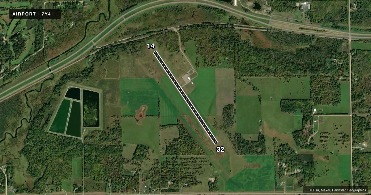
Airport sketch
Runways drawn to scale from FAA survey coordinates, rendered over satellite imagery. Not for navigation.
Approaches & charts
Services on the field
Fuel grades, oxygen, maintenance, ramp storage and lighting — as declared to the FAA by the airport operator.
Fuel & services
- Fuel
- Not available
- Oxygen (bottled)
- Not available
- Oxygen (bulk)
- Not available
- Airframe repair
- Not available
- Power plant repair
- Not available
Ramp & ground
- Transient storage
- Tie-down
- Landing fee
- No fee published
- Lighting schedule
- SEE RMK
- Beacon schedule
- SS-SR
- Beacon
- White / Green (civil land)(WG)
- Wind indicator
- Lighted
- Segmented circle
- No
Fuel & FBOs
Cheapest 100LL and Jet A on the field and nearby. Always confirm with the FBO before taxi.
Airport notes
Surface conditions, obstructions, local procedures, lighting outages and other notes published with each FAA cycle.
General notes
- FOR CD CTC MINNEAPOLIS ARTCC AT 651-463-5588.
Lighting notes
- ACTVT OR INCR INTST REIL RWY 14 & 32; PAPI RWY 14 & 32; MIRL RWY 14/32 - CTAF. MIRL RWY 14/32 PRESET LOW INTST.
Runway surface & condition
- 14/32PAVED & EXTDD ON SE END.
VFR map & nearby airports
VFR sectional. Tap any ICAO chip to open that airport.
Key facts · 7Y4
Answer card- ICAO
- 7Y4
- Name
- BAGLEY MUNI
- Location
- BAGLEY, MINNESOTA
- Elevation
- 1,502.6 ft MSL
- Traffic pattern altitude
- 2,502.6 ft MSL (1,000 AGL)
- Control tower
- Non-towered (use CTAF)
- Total runways
- 1
- Longest runway
- 14/32 · 3,800 ft
- Published ILS approaches
- 0
- Published frequencies
- 1
- Magnetic variation
- 5°
- Current flight rules
- VFR
- Current wind
- Calm / unavailable
- Favored runway now
- –
Bagley Muni sits in Bagley, Minnesota. Field elevation is 1,502.6 ft MSL. The airport has one runway. Runway 14/32 is 3,800 ft of asphalt, so plan your takeoff and landing performance with that length in mind. There is no control tower. CTAF is 122.9.
No ILS approaches are published here. The pattern altitude is not published, so use the standard 1,000 ft AGL pattern unless the current FAA Chart Supplement says otherwise. For this field that works out to about 2,503 ft MSL based on the listed elevation. Runway 14/32 is paved and extended on the southeast end. The runway end identifier lights can be active or brighter on 14 and 32. PAPI is installed on both ends. Medium intensity runway lights are controlled by CTAF and are preset to low intensity.
There are no on-field FBOs listed in the facts. FBO options vary. Contact the airport operator directly before arrival, or call the field on CTAF for current FBO availability. For clearance delivery, contact Minneapolis ARTCC at 651-463-5588. If you are planning a night arrival or a low-weather departure, verify the lighting setup and any current field notes before you go. Bagley is a non-towered field in a rural part of Minnesota, so expect to self-announce clearly and keep an eye out for local traffic.