METAR & TAF KBJI
Current METAR
Observed 02:55Z
KBJI 280255Z AUTO 00000KT 10SM SCT035 SCT043 BKN060 24/22 A2988 RMK AO2 T02370222
- Wind
- 000° @ 0 kt
- Visibility
- 10 SM
- Temp / Dew
- 24°C / 22°C
- Altimeter
- 29.88 inHg
- Clouds
- BKN
- Density alt
- 2,855 ft
- Ceiling
- 6,000 ft AGL
- Rules
- VFR
Airport info & contacts
Manager on record, flight service, ARTCC, attendance schedule and pattern altitude — published by the FAA and refreshed every 28 days.
Location
- From city
- 3 NM NW
- VFR sectional
- TWIN CITIES
- ARTCC
- ZMP · MINNEAPOLIS
- NOTAM facility
- BJI (NOTAM-D)
Airport manager
- Name
- KYLE CHRISTIANSEN
- Phone
- 218-558-5190
- Address
- 3824 MOBERG DRIVE, STE 101, BEMIDJI MN 56601
Flight service · Hours
- FSS PNM
- PRINCETON1-800-WX-BRIEF
- Attendance
- TUE-FRI · 0600-2100
- SAT-SUN · 0800-1700
- MON · 0700-2100
Frequencies
Tap any row to copy the frequency to your clipboard.
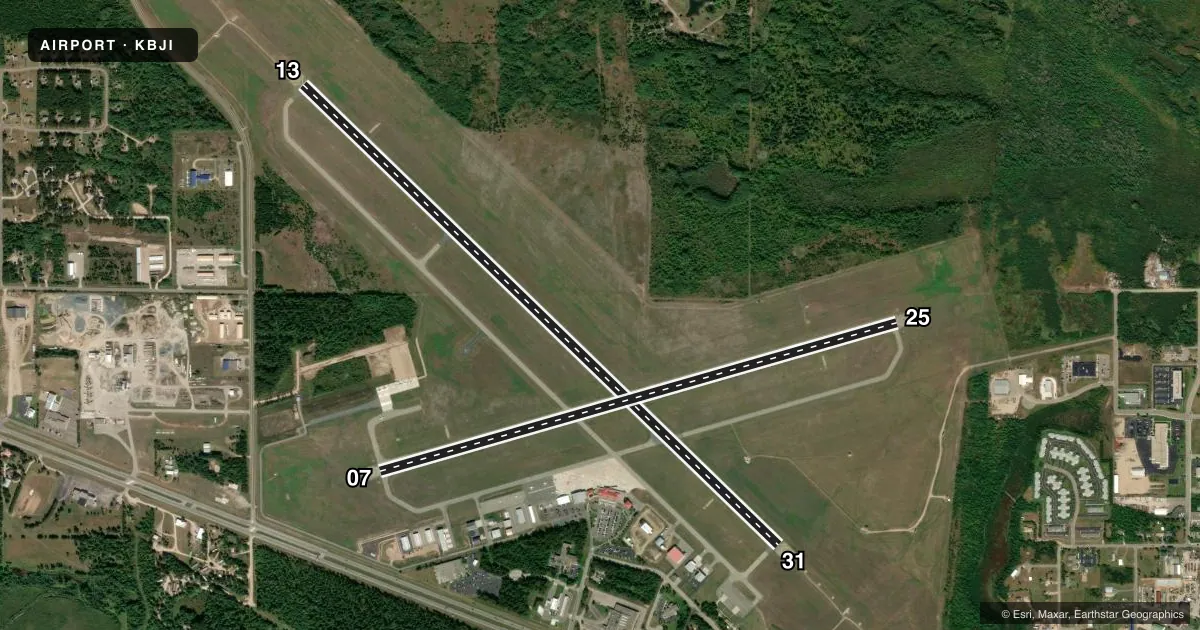
Runways & pattern
Full pagePattern entry · RWY 13
LEFT TRAFFIC| Runway | Heading (°M) | Length | Surface | Traffic |
|---|---|---|---|---|
| 13/31 | 133° / 313° | 7,004 ft | ASPH | Standard L |
| 07/25 | 73° / 253° | 5,700 ft | ASPH | Standard L |
Runway end performance
| End | TORA | TODA | ASDA | LDA | VGSI | Approach lights | Obstruction |
|---|---|---|---|---|---|---|---|
| 13 | 7,002' | 7,002' | 7,002' | 7,002' | PAPI 4-box left(3°) | MALSR | 68', trees, 2278' from thr, 362' R of cntrln, slope 30 |
| 31 | 7,002' | 7,002' | 7,002' | 7,002' | PAPI 4-box left(3°) | MALSR | — |
| 07 | 5,700' | 5,700' | 5,700' | 5,700' | PAPI 4-box left(3°) | — | — |
| 25 | 5,700' | 5,700' | 5,700' | 5,700' | PAPI 4-box left(3°) | — | 35', trees, 1294' from thr, 600' R of cntrln, slope 31 |
Declared distances in feet. TORA = takeoff run available, TODA = takeoff distance, ASDA = accelerate-stop, LDA = landing distance.
Airport sketch
Runways drawn to scale from FAA survey coordinates, rendered over satellite imagery. Not for navigation.
Approaches & charts
ILS · 2
Services on the field
Fuel grades, oxygen, maintenance, ramp storage and lighting — as declared to the FAA by the airport operator.
Fuel & services
- Fuel
- 100LLA
- Oxygen (bottled)
- HIGH/LOW
- Oxygen (bulk)
- Not available
- Airframe repair
- Major
- Power plant repair
- Major
- Other services
- AFRT,AMB,AVNCS,CARGO,CHTR,INSTR,RNTL
Ramp & ground
- Transient storage
- Tie-down
- Hangar
- Landing fee
- No fee published
- Customs
- Not available
- Lighting schedule
- SEE RMK
- Beacon schedule
- SS-SR
- Beacon
- White / Green (civil land)(WG)
- Wind indicator
- Lighted
- Segmented circle
- No
Fuel & FBOs
Cheapest 100LL and Jet A on the field and nearby. Always confirm with the FBO before taxi.
Airport notes
Surface conditions, obstructions, local procedures, lighting outages and other notes published with each FAA cycle.
General notes
- DEER & BIRDS ON & INVOF ARPT.
- SNOW REMOVAL CREWS MONTR CTAF DURG ALL ACR OPS FOR AIRFIELD COND INFO.
- ARFF CREWS MONTR CTAF DURG ALL ACR OPS.
- FOR CD IF UNA TO CTC ON FSS FREQ, CTC MINNEAPOLIS ARTCC AT 651-463-5588.
Lighting notes
- HIRL RY 13/31 PRESET ON LOW INTST; TO INCR INTST & ACTVT REIL RY 07/25; MIRL RY 07/25; MALSR RY 13/31; HIRL RY 13/31 - CTAF. PAPI RY 07, RY 25, RY 13 AND RY 31 OPR CONTINUOUSLY.
Runway surface & condition
- 07/25PCR VALUE: 310/F/A/X/T
- 13/31PCR VALUE: 380/F/A/X/T
Other notes
- 48 HR PPR FOR UNSKED ACR OPNS WITH MORE THAN 30 PSGR SEATS, CALL AMGR 218-444-2438.
- MANAGERAPT MAINT SUPVR, PHONE 218-558-5190. APRT DIRECTOR EMAIL KYLE.CHRISTIANSEN@BEMIDJIAIRPORT.ORG .
VFR map & nearby airports
VFR sectional. Tap any ICAO chip to open that airport.
Key facts · KBJI
Answer card- ICAO
- KBJI
- Name
- BEMIDJI RGNL
- Location
- BEMIDJI, MINNESOTA
- Elevation
- 1,391.4 ft MSL
- Traffic pattern altitude
- 2,391.4 ft MSL (1,000 AGL)
- Control tower
- Non-towered (use CTAF)
- Total runways
- 2
- Longest runway
- 13/31 · 7,004 ft
- Published ILS approaches
- 2
- Published frequencies
- 2
- Magnetic variation
- 1°
- Current flight rules
- VFR
- Current wind
- 000° at 0 kt
- Favored runway now
- –
Bemidji Rgnl sits in Bemidji, Minnesota. Field elevation is 1,391.4 ft MSL. The airport has two asphalt runways. The longest is 13/31 at 7,004 ft. There is no control tower, so expect CTAF traffic flow on 122.8. The published pattern altitude is not listed, so use standard 1,000 ft AGL for light piston aircraft unless the current Chart Supplement says otherwise.
Two ILS approaches are published for runway ends 25 and 31. That gives you an instrument option on both the east-west and north-south pavement. Bemidji Aviation Service is on the field. It carries 100LL and Jet A Prist. Call ahead at (218) 751-1880 for current service status. High intensity runway lighting on 13/31 is preset low. Use CTAF to raise lighting levels and to activate the runway end identifier lights on 07/25. PAPI is listed for all runway ends.
This field is in northern Minnesota. Plan for winter ops, snow removal traffic and wildlife. Deer and birds are reported on and near the airport. Snow removal crews monitor CTAF during aircraft operations. Aircraft rescue and fire fighting crews also monitor CTAF. If you are bringing a large unscheduled flight with more than 30 passenger seats, the airport requires 48 hours prior permission. Check the current FAA Chart Supplement for any other local restrictions before you go.